Kandovan, Osku
| Kandovan كندوان | |
|---|---|
| village | |
|
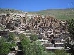
A view of Kandovan rock houses. | |
 Kandovan | |
| Coordinates: 37°47′42″N 46°14′55″E / 37.79500°N 46.24861°ECoordinates: 37°47′42″N 46°14′55″E / 37.79500°N 46.24861°E | |
| Country |
|
| Province | East Azerbaijan |
| County | Osku |
| Bakhsh | Central |
| Rural District | Sahand |
| Population (2006) | |
| • Total | 601 |
| Time zone | IRST (UTC+3:30) |
| • Summer (DST) | IRDT (UTC+4:30) |
Kandovan (Persian: كندوان, also Romanized as Kandovān and Kandavān; also known as Kanvān)[1] is a village in Sahand Rural District, in the Central District of Osku County, East Azerbaijan Province, Iran. This village exemplifies manmade cliff dwellings which are still inhabited. The troglodyte homes, excavated inside volcanic rocks and tuffs similar to dwellings in the Turkish region of Cappadocia, are locally called "Karaan". Karaans were cut into the Lahars (volcanic mudflow or debris flow) of Mount Sahand. The cone form of the houses is the result of lahar flow consisting of porous round and angular pumice together with other volcanic particles that were positioned in a grey acidic matrix. After the eruption of Sahand these materials were naturally moved and formed the rocks of Kandovan. Around the village the thickness of this formation exceeds 100 m and with time due to water erosion the cone shaped cliffs were formed.[2] At the 2006 census, the village population was 601, in 168 families.[3]
Photo Gallery
-
Far view of a hotel on the left and the rock houses on the right
-
Closer view of the village
-
In the village
-
In the village
-
Interior of a traditional home
-
View of the village and surroundings from the rock houses
References
- ↑ Kandavan can be found at GEOnet Names Server, at this link, by opening the Advanced Search box, entering "-3813310" in the "Unique Feature Id" form, and clicking on "Search Database".
- ↑ Siamak Hashemi, 2013, The Magnificence of Civilization in Depths of Ground (A Review of Underground Structures in Iran – Past to Present), Shadrang Printing and Publishing Co., Tehran.
- ↑ "Census of the Islamic Republic of Iran, 1385 (2006)" (Excel). Islamic Republic of Iran. Archived from the original on 2011-11-11.
- Cones of Kandovan, Jadid-Online
External links
| Wikimedia Commons has media related to Kandovan. |
| ||||||||||||||||||||||||||||||||||||||||||||||||||
| ||||||||||||||||||||||||||||||||||||||||||||


