Kander (Switzerland)
| Kander | |
| River | |
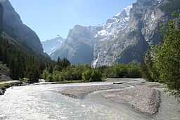 The Kander in the Gasterntal | |
| Country | Switzerland |
|---|---|
| State | Bern |
| Tributaries | |
| - left | Engstlige, Simme |
| - right | Öschibach, Chiene, Suld |
| Source | |
| - location | Kander Glacier, Switzerland |
| - elevation | 2,200 m (7,218 ft) |
| - coordinates | 46°27′53″N 07°45′54″E / 46.46472°N 7.76500°E |
| Mouth | |
| - location | Lake Thun, Switzerland |
| - elevation | 558 m (1,831 ft) |
| - coordinates | 46°43′02″N 07°38′22″E / 46.71722°N 7.63944°ECoordinates: 46°43′02″N 07°38′22″E / 46.71722°N 7.63944°E |
| Length | 44 km (27 mi) |
The Kander is a river in Switzerland. It is 44 kilometres (27 mi) long and has a watershed of 1,126 square kilometres (435 sq mi). Originally a tributary of the Aar river, with a confluence downstream of the city of Thun, since 1714 it has flowed into Lake Thun upstream of the city. The valley through which the river flows is known as the Kandertal or, in specific sections, as the Gastertal or Frutigtal.
Course
The source of the Kander is fed from the Kanderfirn glacier in the Blüemlisalp massif. Initially the river in an easterly direction, until it turns sharply north just south of the village of Kandersteg. This section of the valley is known as the Gastertal.[1]
In Kandersteg, the Öschibach, a tributary stream that drains the Oeschinensee, joins the Kander. The river then runs north through Kandergrund as far as Frutigen, where it is joined by another tributary, the Engstlige.[2]
Below Frutigen the river flows through Reichenbach im Kandertal, where it meets the Chiene, and Mülenen, where it meets the Suld. Finally, near the village of Wimmis, it meets the Simme. The valley downstream of Frutigen is known as the Frutigtal.[2]
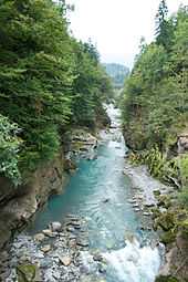
The last short section of today's river, the Kanderschlucht or Kander canyon, is artificial, having been created as a result of the Kander Correction (see below). At the end of the canyon, the river flows into Lake Thun.[2]
Between Mülenen and Kandersteg, the river is followed by the Lötschberg railway line on its climb to the northern portal of the Lötschberg tunnel, which passes under the Gastertal on its way to Brig and the Rhone Valley. A road also follows the valley to Kandersteg and beyond into the Gastertal, but unlike the railway this is a dead-end, with no through road route across the mountains.[1][2]
Kander Correction
The Kander originally flowed through the low lying Thun Allmend area and entered the Aar river between the city of Thun and Uttigen. As a result, the Allmend was repeatedly subject to flooding.[3]
As the river flowed within a few hundred meters on Lake Thun, there were early proposals to divert the river into the lake, thus avoiding the Allmend and removing the cause of its flooding. At the beginning of the 18th Century, the engineer Samuel Bodmer created plans, involving a cutting through the Strättlighügel ridge that separated the river and lake.[3]
The plans were approved in 1711, and work began but was delayed by the second Battle of Villmergen. In the spring of 1713 work restarted under the direction of Bern's city architect Samuel Jenner, but with of a tunnel instead of the unfinished cutting. Work was finished by the end of the year, but in 1714, the river started to enlarge the channel, causing the tunnel to collapse and creating today's Kanderschlucht or Kander canyon.[3]
The Kander correction was the first pieces of major water course re-engineering in Switzerland and lack of experience subsequently led to problems. The amount water flowing into Lake Thun was increased by 60%, with a commensurate increase in outflow through the city of Thun. This caused flooding and bank correction, which has been addressed over the years in different ways, including channeling of the Aar in 1716, a more major correction of the Aar in the 1870s, and a flood relief tunnel in the early 21st century.[3]
Navigation
With respect to rafting, the Kander is classified as unrunnable (level VI on the International Scale of River Difficulty) due to the river's numerous rapids and barriers. In 2008, a Swiss Army rafting party's inflatable boats capsized during an attempt to navigate the river; five soldiers were killed.[4]
References
- ↑ 1.0 1.1 map.geo.admin.ch (Gastertal) (Map). Swiss Confederation. Retrieved 2013-01-28.
- ↑ 2.0 2.1 2.2 2.3 map.geo.admin.ch (Frutigtal) (Map). Swiss Confederation. Retrieved 2013-01-28.
- ↑ 3.0 3.1 3.2 3.3 Vischer, Daniel L. (2003). Die Geschichte des Hochwasserschutzes in der Schweiz - Von den Anfängen bis ins 19. Jahrhundert [The story of the flood protection in Switzerland - From the beginnings to the 19th Century]. Berichte des BWG, Serie Wasser – Rapports de l’OFEG, Série Eaux – Rapporti dell’UFAEG, Serie Acque, Nr. 5) (in German) (Biel: Herausgegeben vom Bundesamt für Wasser und Geologie BWG). pp. 60–69.
- ↑ Dale Bechtel and Scott Capper (June 12, 2008). "River tragedy strikes Swiss army". Swissinfo.
External links
-
 Media related to Kander at Wikimedia Commons