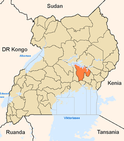
Kamuli District
| Kamuli District | |
|---|---|
| District | |
 District location in Uganda | |
| Coordinates: 00°55′N 33°06′E / 0.917°N 33.100°ECoordinates: 00°55′N 33°06′E / 0.917°N 33.100°E | |
| Country |
|
| Region | Eastern Uganda |
| Sub-region | Busoga sub-region |
| Capital | Kamuli |
| Area | |
| • Land | 1,557 km2 (601 sq mi) |
| Elevation | 1,100 m (3,600 ft) |
| Population (2012 Estimate) | |
| • Total | 500,800 |
| • Density | 321.6/km2 (833/sq mi) |
| Time zone | EAT (UTC+3) |
| Website |
www |
Kamuli District is a district in Eastern Uganda. Like most other Ugandan districts, it is named after its 'chief town' of Kamuli.
Location
Kamuli District is bordered by Buyende District to the north, Luuka District to the east, Jinja District to the south and Kayunga District to the west.[1] The district headquarters at Kamuli are located approximately 74 kilometres (46 mi), by road, north of Jinja, the largest city in Busoga sub-region.[2] The coordinates of the district are:00 55N, 33 06E.
Population
As of December 1991, Kamuli District had a population of about 249,300, according to the nation population census conducted that year. In 2002, the next population census estimated the district population at approximately 361,400, with 40.5% males and 59.5% females. It is estimated that as of 2012, the district population was about 500,800.[3] The next national population census is scheduled for August 2014.[4]
Ethnicity and Language
Kamuli District is a multi-ethnic and multi-cultural society, with the predominant ethnic group being the Basoga who comprise 76% of the population. The Iteso make up 3.9% and the Banyoro and Bagungu together make up 1.8%. Other Ugandan ethnicities make up the rest (18.3%). The predominantly language spoken in Kamuli District is Lusoga, with some Luganda and English.[5]
The district is part of Busoga sub-region which is coterminous with the Kingdom of Busoga. In 2002, the sub-region was home to an estimated 2.5 million people, according to the national census conducted that year. The districts that constitute Busoga sub-region include the following:
Economic Activity
Means of earning a livelihood in Kamuli District include:[6]
- Fishing
- Ranching
- Farming
- Fish farming
- Bee keeping
- Retail trade
- Quarrying
The crops grown include the following:
- Upland rice
- Paddy rice
- Matooke
- Sweet bananas
- Maize
- Millet
- Soybeans
- Groundnuts
- Oranges
- Mangoes
- Potatoes
- Beans
- Simsim
- Sunflower
- Tomatoes
- Onions
- Coffee
- Cotton
- Sugarcane
Livestock kept includes cattle, goats, sheep, and chicken.
See also
References
- ↑ Uganda District Map
- ↑ "Road Distance Between Jinja And Kamuli With Map". Globefeed.com. Retrieved 12 May 2014.
- ↑ "Estimated population of Kamuli District In 1991, 2002 & 2012". Citypopulation.de. Retrieved 12 May 2012.
- ↑ Mugalu, Moses (12 December 2013). "Census to Offer 150,000 Jobs". The Observer (Uganda). Retrieved 12 May 2014.
- ↑ Isaac Mufumba, Opio Sam Caleb (25 November 2013). "Kamuli, The District of Firsts". Daily Monitor. Retrieved 12 May 2014.
- ↑ "The Economic Activities In Kamuli District". Uganda Travel Guide. Retrieved 12 May 2014.
External links
| ||||||||||||||||||