Kamp-Lintfort
| Kamp-Lintfort | ||
|---|---|---|
|
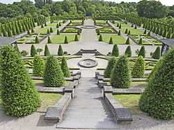
Terraced gardens of Kamp Abbey | ||
| ||
 Kamp-Lintfort | ||
Location of Kamp-Lintfort within Wesel district 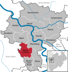
 | ||
| Coordinates: 51°30′00″N 06°32′0″E / 51.50000°N 6.53333°ECoordinates: 51°30′00″N 06°32′0″E / 51.50000°N 6.53333°E | ||
| Country | Germany | |
| State | North Rhine-Westphalia | |
| Admin. region | Düsseldorf | |
| District | Wesel | |
| Government | ||
| • Mayor | Christoph Landscheidt (SPD) | |
| Area | ||
| • Total | 63.16 km2 (24.39 sq mi) | |
| Population (2013-12-31)[1] | ||
| • Total | 36,973 | |
| • Density | 590/km2 (1,500/sq mi) | |
| Time zone | CET/CEST (UTC+1/+2) | |
| Postal codes | 47475 | |
| Dialling codes | 0 28 42 | |
| Vehicle registration | WES | |
| Website | www.kamp-lintfort.de | |

Kamp-Lintfort is a town in Wesel District, in North Rhine-Westphalia, Germany. It is located 8 kilometres (5 miles) north-west of Moers.
International relations
Twin towns — sister cities
Kamp-Linfort is twinned with:
 Żory in Poland
  Chester-le-Street in the United Kingdom
| ||||||||
References
- ↑ "Amtliche Bevölkerungszahlen". Landesbetrieb Information und Technik NRW (in German). 4 September 2014.