Kamo, Okayama
| Kamo 加茂町 | |
|---|---|
| Former municipality | |
|
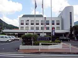
Former Kamo town hall | |
 Kamo Location in Japan | |
| Coordinates: 35°10′41.4″N 134°3′14.5″E / 35.178167°N 134.054028°ECoordinates: 35°10′41.4″N 134°3′14.5″E / 35.178167°N 134.054028°E | |
| Country | Japan |
| Region | Chūgoku |
| Prefecture | Okayama Prefecture |
| District | Tomata |
| Merged |
February 28, 2005 (now part of Tsuyama) |
| Area | |
| • Total | 159.27 km2 (61.49 sq mi) |
| Population (2003) | |
| • Total | 5,311 |
| • Density | 33.35/km2 (86.4/sq mi) |
| Time zone | Japan Standard Time (UTC+9) |
| Symbols | |
| - Tree | Chamaecyparis obtusa |
| - Flower | Satsuki azalea |
| - Bird | Japanese Bush-warbler |
Kamo (加茂町 Kamo-chō) was a town located in Tomata District, Okayama Prefecture, Japan.
As of 2003, the town had an estimated population of 5,311 and a density of 33.35 persons per km². The total area was 159.27 km².
On February 28, 2005, Kamo, along with the village of Aba (also from Tomata District), the town of Shōboku (from Katsuta District), and the town of Kume (from Kume District), was merged into the expanded city of Tsuyama and no longer exists as an independent municipality.
Geography
Adjoining municipalities
Education
- Kamo Elementary School
- Kamo Junior High School
Transportation
Railways
Road
- Prefectural roads:
External links
- Official website of Tsuyama in Japanese (some English content)