Kallawaya mountain range
| Kallawaya mountain range | |
|---|---|
|
| |
| Highest point | |
| Peak | Allin Qhapaq |
| Elevation | 5,780 m (18,960 ft) |
| Dimensions | |
| Length | 75 km (47 mi) N-S |
| Geography | |
| Country | Peru |
| State/Province | Puno Region |
| Parent range | Andes |
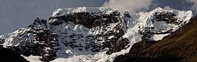
The Kallawaya mountain range[1] (hispanicized spelling Carabaya) lies in the Andes of Peru. It extends between 14°00' and 14°22'S and 69°38' and 70°19'W for about 75 km.[2] It is located in the Puno Region, Carabaya Province, between the Willkanuta mountain range in the north-west and the Apolobamba mountain range in the south-east, north and north-east of Makusani.
Mountains
The highest mountain in the range is Allin Qhapaq at 5,780 metres (18,963 ft). Other notable peaks are:
- Balansani, 5,350 metres (17,552 ft)
- Ch'ichi Qhapaq, 5,614 metres (18,419 ft)
- Chullumpirini, c. 5,000 metres (16,404 ft)
- Muru Muruni, c. 5,200 metres (17,060 ft)
- Pumaqulluni, c. 5,200 metres (17,060 ft)
- Qaqa Qhapaq, 5,425 metres (17,799 ft)
- Qillwaquta Rit'i, 5,400 metres (17,717 ft)
- Qiruni, 5,250 metres (17,224 ft)
- Tuku Qhapaq (or T'uqu Qhapaq), 5,670 metres (18,602 ft)
- Wayna Qhapaq, 5,721 metres (18,770 ft)
- Wila Kunka, 5,350 metres (17,552 ft)
- Wilaquta, 5,000 metres (16,404 ft)
- Yura Qhapaq, 5,610 metres (18,406 ft).[3][4][5]
See also
References
- ↑ Teofilo Laime Ajacopa, Diccionario Bilingüe Iskay simipi yuyayk'ancha, La Paz, 2007 (Quechua-Spanish dictionary): kallawaya. - s. Provincia de Antisuyu. Los habitantes de dicha provincia eran y siguen siendo hábiles herbolarios (JL). || Código idiomático usado por los herbolarios llamados kallawayas.
- ↑ usgs.gov USGS, Peruvian Cordilleras
- ↑ Taken from Mountaineering in the Andes by Jill Neate RGS-IBG Expedition Advisory Centre, 2nd edition, May 1994
- ↑ Michael Cocker, Frost, Dust and Tear Gas, Exploratory Mountaineering in the Peruvian Cordillera Carabaya, in: Alpine Journal 2008, p. 53-69
- ↑ allthemountains.com Maps of the Eastern Andes of Peru including two maps of the Kallawaya mountain range (inactive website)