Kalavalapalli
| Kalavalapalli కలవలపల్లి Kalavalapalle | |
|---|---|
| village | |
 Kalavalapalli Location in Andhra Pradesh, India | |
| Coordinates: 16°56′N 81°38′E / 16.93°N 81.63°ECoordinates: 16°56′N 81°38′E / 16.93°N 81.63°E | |
| Country |
|
| State | Andhra Pradesh |
| District | West Godavari district |
| Government | |
| • Type | Panchayat |
| • Body | Kalavalapalli |
| Area | |
| • Total | 12.75 km2 (4.92 sq mi) |
| Population (2001) | |
| • Total | 5,575 |
| • Density | 440/km2 (1,100/sq mi) |
| Languages | |
| • Official | Telugu |
| Time zone | IST (UTC+5:30) |
| PIN | 534301 [1] |
| Telephone code | 08813 [2] |
| Vehicle registration | AP37 |
| Nearest city | Nidadavole |
| Lok Sabha constituency | Rajahmundry |
| Vidhan Sabha constituency | Kovvur |
| Civic agency | Kalavalapalli |
Kalavalapalli is a village in Chagallu mandal in West Godavari district in Andhrapradesh state in India.

It is the smallest and least populated village in the Chagallu mandal.
History
It was a fort surrounded by water bodies (Jaladurgam) of East Chalukyan kings. Chalukya Bhima, the builder of Draksharama Bhimeswara temple won this land from Rastrakutas, the then ruling dynasty. Veerabhadra Chalukya, a ruler of this place married Rani Rudrama Devi, a prominent ruler and warrior princess of Kaakateeya dynasty. It had 108 siva temples, many of them were totally destroyed by Md. Bin Tughlaq in 1323. Even today can find 6 feet destroyed sculptures of that age. A beautiful Nandi of 13th century placed in Sri Golingeswara temple discovered in School building construction. It has history erstwhile Rajahmundry's.

Important Places to visit
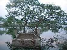
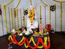
There are a few places to visit such as Lord Siva Temple, Sai Baba Temple [new], etc. Sai Baba Temple is newly constructed [in 2012]. But Lord Siva Temple is an ancient temple. Also a large pond lies in front of it which is considered very pious. It is believed that another temple lies under this pond.


Political Context
For few years the village supported Telugu Desam Party TDP when Nandamuri Taraka Rama Rao [NTR] started his party TDP. Later, the villagers started showing political maturity and started casting their votes based on the candidate's personal profile.
Climate
Kalavalapalli falls in the hot humid region of the country. The climate of the city is hot in the summers and it is pleasant during the winter. The hottest day falls in the month of May with shift to June during some years. Simply, the weather is moderate.
Land & Agriculture
The village has a total geographical area of 1265 hectares. Kalavalapalli is the smallest village in the mandal. Out of this total land, 1138 hectares is used for Agriculture and cultivation, which is about 90% of total land. In this total cultivated land, about 1100 hectares is irrigated and 38 hectares is unirrigated, which says that about 96.66% of cultivated land is irrigated. Village land is divided into two halfs pallam (lower land) which is covered with Black soil and meraka (upper land) which is covered with Red soil. Kalavalapalli is unique as it shares the two different land areas Black and Red. All other villages have either Black or Red soil.
Land Particulars according to 2001 census
| Type of land | Area (in hectares) |
|---|---|
| Irrigated | 1100.34 |
| Unirrigated | 37.64 |
| Household | 127.02 |
| Total | 1265 |
Agriculture or cultivation is the main source of income of people. Main crops are paddy, sugarcane, coco, coconut. Land is highly fertile and can produce three crops per year with available irrigation. Villagers sell sugarcane to the near famous sugar factory, Jeypore Sugar Company Ltd.[3] Approximately all the area of kalavalapalli village is covered by agricultural lands mostly paddy and coconut. Other plantations include palm oil, coco (raw material which is used to produce chocolates), banana, tobacco, sugarcane and other vegetable crops which are considerably less.
Recently several Industries have been established based on these crops. These include Rice mills, Coconut Fibre Production Units, and Copra production units. The major exports are Coconuts (Tender and Mature) and Coconut based products (Copra, Coir, Coir Pith, Coir Pith Compost). Others include Cocoa beans, Palm oil, Paddy / Rice etc.
Culture
Villagers follow a purely the Godavari Style in culture and traditions. They celebrate every festival very traditionally. Even Dramas, Costume displays, rural carnivals will be held at time of Maha Siva Rathri and Subramanya Sashti.

Population
According to 2001 census, Kalavalapalli village has population of 5565. Number of families was found to be 1264. Village has a sex ratio of 949:1000 with 2856 male and 2709 female population. This village is the least populated village in the Mandal. It is expected to rise to 10,000 by 2011.
| Quantity (2001 census) | Value |
|---|---|
| Male population | 2856 |
| Female population | 2709 |
| Total population | 5565 |
| Number of Households | 1264 |
| Sex Ratio | 949 |
Transport
Transport facilities are very bad. Only a single bus runs through the village that too only in 9-10 months a year. Main mode of transport is Auto. There is a bus stand near Lord Siva Temple and an Auto stand at main road.
Education
One Government MPUP school and two primary schools are present in the village. Most Students go for private schools and colleges in Nidadavole.
Popular families
Main families are Edara, Aalam, Aatkuri, Abburi, Alapati, Arumilli, Bikkina, Burugapalli, Dommeti, Gaggara, Gannamani, Gudapati, Jasthi, Jonna, Kakarla, Karinki, Kodavati, Kondepati, Maddipati, Mullapudi, Muppidi, Nalluri, Nandigam, Naramamidi, Nimmagadda, Patkuri, Pedhavegi, Ravipati, Sunkavalli, Taduri, Taninki, Sanam etc.
Cinepeople from the Village
Two young directors Naren Kondepati[4] and Veerabhadram Chowdary[5] from the village directed few Telugu films.
- Naren Kondepati - Jayeebhava
- Veerabhadram - Aha Naa Pellanta, Poola Rangadu, Bhai
Distance to cities and towns from Kalavalapalli
Hyderabad -415 km
Nidadavole -7 km
Rajahmundry -30 km
Tanuku -36 km
Eluru -85 km
Tadepalligudem-27 km
Palakollu -55 km
Kakinada -85 km
Bhimavaram -60 km
Narsapur -65 km
Vijayawada -140 km
Vishakapatnam -215 km