Kalapara Upazila
| Kalapara কলাপাড়া | |
|---|---|
| Upazila | |
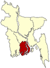
 Kalapara Location in Bangladesh | |
| Coordinates: 21°59.2′N 90°14.5′E / 21.9867°N 90.2417°ECoordinates: 21°59.2′N 90°14.5′E / 21.9867°N 90.2417°E | |
| Country |
|
| Division | Barisal Division |
| District | Patuakhali District |
| Area | |
| • Total | 483.08 km2 (186.52 sq mi) |
| Population (1991) | |
| • Total | 174,921 |
| • Density | 362/km2 (940/sq mi) |
| Time zone | BST (UTC+6) |
Kalapara (Bengali: কলাপাড়া , also known as Khepupara) is an Upazila of Patuakhali District in the Division of Barisal, Bangladesh.
Geography
Kalapara is located at 21°59′10″N 90°14′32″E / 21.9861°N 90.2422°E . It has 31324 units of house hold and total area 483.08 km². The major rivers are the Andharmanik, Nilganj, and Dhankhali.[1]
Demographics
As of the 1991 Bangladesh census, Kalapara has a population of 174921. Males constitute 50.89% of the population, and females 49.11%. This Upazila's eighteen up population is 82394. Kalapara has an average literacy rate of 34.9% (7+ years), and the national average of 32.4% literate.[2]
Administration
- Member of Parliament: Mahbubur Rahman Talukder
- Chairman: Motaleb Talukder
- Woman Vice Chairman: Bilkich Jahan
- Vice Chairman: Mostafa
- Upazila Nirbahi Officer (UNO): Dider-e-Alam Mohammad Maksud Chowdhury[3]
Administrative
Kalapara thana was established in 1921 and was turned into an upazila in 1983.[1] It consists of 9 union parishads, 57 mouzas and 247 villages. Kalapara town consists of 9 wards and 24 mahallas. The area of the town is 19.49 km2. It has a population of 16330; male 55.18%, female 44.82%. The density of population is 838 per km2. The literacy rate among the town people is 39.37%. The town has one bungalow.
Archaeological heritage
Kuakata Buddhist Vihara, Kapradanga Buddhist Math (dilapidated), Mistripara Buddhist Vihara (dilapidated).
Historical events
The Rakhain tribe of Bangladesh first settled in this upazila. A section of the people belonging to the Buddhist Rakhain tribe of Arakan came to this upazila in quest of better living and first settled at Khepupara and Kuakata. Tradition goes that the Rakhains on excavating wells traced fresh water in the area and thereby settled there. The Rakhain word 'kansai' means 'beach of fate'. The place was named as Kansai after this. The place was subsequently renamed as Kuakata (digging of well) after the wells dug out by the Rakhanis. The upazila though named as Kalapara, the upazila sadar is known as Khepupara. It is said that two influential Rakhain chiefs used to reside on either side of a canal running northsouth through the upazila, Kalau Magh on the eastern bank and Khepu Magh on the western side. The habitation on eastern bank of the canal was named as Kalapara after the name of Kalau Magh and that on the western bank as Khepupara after Khepu Magh.
Religious institutions
Mosque 275, temple 41, pagoda 4, Buddhist Vihara 8, church 2, mazar 1. Notable institutions: Kalapara Jami Masjid, Kuakata Buddhist Vihara, mazar of pir Bashiruddin at Kalapara.
See also
References
- ↑ 1.0 1.1 Ekramul Kabir (2012). "Kalapara Upazila". In Sirajul Islam and Ahmed A. Jamal. Banglapedia: National Encyclopedia of Bangladesh (Second ed.). Asiatic Society of Bangladesh.
- ↑ "Population Census Wing, BBS.". Archived from the original on 2005-03-27. Retrieved November 10, 2006.
- ↑
| |||||||||||||||||||||||||||||||||