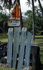
Kalapana, Hawaii
Kalapana[1] is a town and region in the Puna District on the Island of Hawaiʻi in the Hawaiian Islands and can be reached either by Hawaii Route 130 from Pāhoa or by Hawaii Route 137.
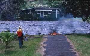
The area gained notoriety when the 1986 Kīlauea lava flow from the Kupaianaha vent destroyed and partly buried most of the town, as well as Kalapana Gardens and nearby Royal Gardens subdivisions. The lava flow that destroyed Kalapana erupted from the southeast rift zone of Kīlauea. Along with the destruction of Kalapana were those of the nearby town of Kaimū and Kaimū Bay, both of which now lie buried beneath more than 50 feet of lava. The lava flow also created a new coastline.
Although most access to the town has been cut off, a few people still live there, but mostly need to get in and out by 4-wheel drive vehicles.
In July 2010, lava from Kīlauea continued into the Kalapana region destroying a home that was only 5 years old, leaving 35 homes remaining in the Kalapana Gardens Subdivision.[2] The latest flow partly covered the 1986-1992 flow field again, while attracting thousands of visitors a day.[3]
References
- ↑ Mary Kawena Pukui, Samuel Hoyt Elbert and Esther T. Mookini (2004). "lookup of Kalapana". in Place Names of Hawai'i. Ulukau, the Hawaiian Electronic Library, University of Hawaii Press.
- ↑ "Lava threat to Kalapana Gardens subdivision on Big Island | KHON2 Hawaii's News Channel". Khon2.com. Archived from the original on 2012-03-06. Retrieved 2010-07-27.
- ↑ July 21, 2010 (2010-07-21). "RAW VIDEO: Lava slowly advances towards Kalapana homes". Big Island Video News. Retrieved 2010-07-27.
External links
| Wikimedia Commons has media related to Kalapana, Hawaii. |
- U.S. Geological Survey Geographic Names Information System: Kalapana
- USGS: Pictures and information on Kalapana's destruction
Coordinates: 19°22′09″N 154°57′52″W / 19.3693°N 154.9645°W
| |||||||||||||||||||||||||

| |||||||||||||||||||||||||||||||||||||
