Kalam, Swat
| Kalam | |
|---|---|
| Tehsil | |
 Kalam Valley | |
| Country |
|
| Province | Khyber Pakhtunkhwa |
| District | Swat |
| Time zone | PST (UTC+5) |
| Number of towns | ADD HERE |
| Number of Union Councils | ADD HERE |
Kalam (Urdu: کالام ) is an administrative subdivision (Tehsil) of Swat District in the Khyber Pakhtunkhwa province of Pakistan.

Kalam is along the upper reaches of the Swat River in Swat Valley.

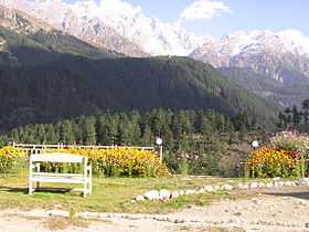
Kalam is known for its waterfalls, lakes and lush green hills, and is a 270 km drive from Islamabad, the capital of Pakistan. It is a popular destination for tourists.
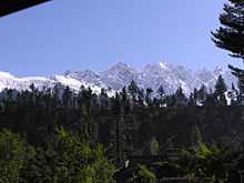
At 29 kilometres (18 miles) from Bahrain and about 2,000 meters (6,600 feet) above sea level, the valley opens out, providing rooms for a small but fertile plateau above the river.[1] In Kalam the Ushu and Utrot rivers join to form the Swat River. Here, the metalled road ends and shingle road leads to the Ushu and Utrot valleys. From Matiltan some snow-capped mountains are visible including Mount Falaksir 5,918 meters (19,416 feet), and another unnamed peak 6,096 meters (20,000 feet) high.

See also
- Kohistani language
- Mahodand Lake
- Swat Valley
References
- ↑ Tourists Guide >> Places to Visit >> Kalam Publisher: swat valley.com, Retrieved on 29 September 2012
| Wikimedia Commons has media related to Kalam Valley. |
Coordinates: 35°28′48″N 72°35′15″E / 35.4801°N 72.5874°E