Kaikoura Peninsula
| Kaikoura Peninsula | |
|---|---|
|
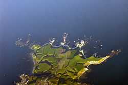
Aerial view of the Kaikoura Peninsula | |
| Location | |
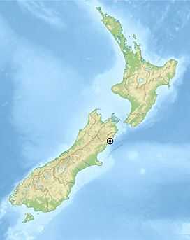
 New Zealand | |
| Coordinates | 42°25′23″S 173°42′00″E / 42.423°S 173.700°ECoordinates: 42°25′23″S 173°42′00″E / 42.423°S 173.700°E |
| Geology | |
| Type | Limestone, mudstone |
| Age of rock | Quaternary |
The Kaikoura Peninsula is located in the northeast of New Zealand's South Island. It protrudes five kilometres into the Pacific Ocean. The town of Kaikoura is located on the north shore of the peninsula. The peninsula has been settled by Maori for approximately 1000 years, and by Europeans since the 1800s, when whaling operations began off the Kaikoura Coast. Since the end of whaling in 1922 whales have been allowed to thrive and the region is now a popular whale watching destination.
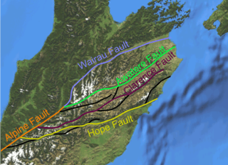
The Kaikoura Peninsula is made up of limestone and mudstone which have been deposited, uplifted and deformed throughout the Quaternary. The peninsula is situated in a tectonically active region bounded by the Marlborough Fault System.
The Kaikoura Canyon is a submarine canyon situated 500 metres off the coast to the south-east of the peninsula. It is 60 km long, up to 1200 m deep, and is generally U-shaped. It is an active canyon that merges into a deep-ocean channel system that meanders for hundreds of kilometres across the deep ocean floor.
History
The peninsula has been inhabited by Māori for the best part of 1000 years. They used it as a base for hunting moa, and also harvested the plentiful crayfish which are found along the shore. In legend, it was from this peninsula that legendary hero Māui is reputed to have dredged up the giant fish that became the North Island.
During the 19th century, European whaling stations were established in the area. In more recent times, the whales that visit the coast off the peninsula have been allowed to thrive, and whale-watching makes the area a popular ecotourism destination. Whales frequent these coastal waters because squid and other deep-sea creatures are brought from the deep Hikurangi Trench to the surface by the combination currents and steeply sloping seafloor.
Geology and geomorphology

The Kaikoura Peninsula is located on the east coast of the South Island of New Zealand. Geologically the peninsula consists of an asymmetrical anticline bounded on either side by two synclines, the axis of which strikes northeast–southwest.[1] The peninsula is made up of two different types of sedimentary rocks, the Amuri Limestone of Palaeocene age and Oligocene aged mudstone. Intense folding and minor faulting have occurred, particularly in the limestone area. Shore platforms are developed in both lithological units, those in limestone displaying wider variability in morphology. The multi-level terraces were once wave-cut platforms, created at sea level and uplifted out of the sea by tectonic processes, at which point the next step would be cut. In the landscape they appear as a flight of terraces with the oldest appearing at the top and the youngest at the shoreline where the Kaikoura township is situated.[2]
The shoreline of the Kaikoura Peninsula is exposed to an extremely long fetch from the Pacific Ocean, and it is also characterized as a high-energy oceanic swell environment, with high-energy storms interrupting long periods of relative calm. High-energy storms due to the passage of cyclonic depressions over New Zealand can occur at any time of the year. The Kaikoura Coast is mesotidal with a mean range of 1.36 m and a maximum of 2.57 m. The region has a temperate climate with moderate rainfall, averaging 865 mm per year and mean monthly temperatures range from 7.7° Celsius in July to 16.2° Celsius in January.[1]
The Kaikoura Peninsula environment is subject to highly energetic processes in terms of both marine and weathering processes. Shore platforms are exposed to the dominant wave directions and are in the intertidal zone. Consequently, both marine erosive forces and subaerial weathering processes contribute to erosion.[3] Shore platforms range from 40 m to over 200 m wide and are cut in Tertiary mudstones and limestones.
Tectonic uplift of the peninsula is estimated to be in the order of 100 metres during the Quaternary and 2 metres during the last 1000 years. The shore platforms are therefore clearly polycyclic and contain inherent morphological features but are being actively rejuvenated by the removal of cover deposits.
Four main phases of tectonic activity are identified for the last 5–6000 years. These involve changing tectonic-eustatic levels, platform processes and erosional episodes in the hinterland. Consequently the platforms are rapidly evolving features which reflect both contemporary processes and recent tectonic history.[1]
Kaikoura Canyon
The Kaikoura Canyon is a submarine canyon located southwest of the Kaikoura Peninsula off the northeastern coast of the South Island. It is 60 km long, up to 1200 m deep, and is generally U-shaped. It is an active canyon that merges into a deep ocean channel system that meanders for hundreds of kilometres across the deep ocean floor.[4] It is the main sediment source of the 1500 km long Hikurangi Channel, which supplies turbidites to the Hikurangi Trough, as well as to low parts of the oceanic Hikurangi Plateau, and to the edge of the southwest Pacific Basin. It is deeply incised into the narrow, tectonically active, continental margin. It is thought to be the sink for the coastal sediment transport system that carries large amounts of erosional debris northwards up the coast from the rivers draining the tectonically active mountains of the South Island.[5]
Landslide tsunami hazard

There is a known risk of an earthquake-triggered tsunami resulting from the displacement of sediment accumulating at the mouth of the canyon. Sediment consisting of fine sand and silt is being deposited at the head of the Kaikoura Canyon with an estimated total volume of 0.24 cubic kilometres accumulated. A near-field tsunami caused by the displacement of this sediment poses a significant threat to the surrounding area, especially coastal infrastructure such as roads and houses.[6]
Historical accounts of canyon-related tsunami in this region are uncertain. Geological evidence is also limited, and no palaeotsunami specific studies have been carried out to date. However in archaeological literature, there are some possible indications of past marine inundation events. Marine sediments can be seen to overlie an historical Maori occupation site on Seddon's Ridge, near South Bay. These deposits indicate that marine inundation occurred sometime within the last 150–200 years. Seddon's Ridge is an uplifted beach ridge and has a long history of Maori settlement. An older village site dating from approximately 650 years before present, situated approximately 350 metres from the shoreline, contains reworked oven stones which are overlain by marine overwash deposits. Without accompanying reliable geological data, this kind of archaeological evidence is only circumstantial. However it does indicate that the ocean has inundated past coastal settlements in the region as a result of a severe storm surge or tsunami.[7]
Rapidly accumulating sandy sediment on a steep slope, in an active tectonic region, is likely to be susceptible to failure during moderately large earthquakes. Strong ground shaking associated with rupture on nearby faults can be expected to reduce the shear strength of the sandy sediment deposit at the Canyon Head and may trigger mass failures.

It is estimated that an earthquake magnitude 8 on the Richter Scale or shaking equivalent to 5 on the Modified Mercalli earthquake scale would be enough to trigger such an event. The Kaikoura Region is adjacent to the Marlborough fault zone. There are a number of faults in this area predicted to have the capacity to produce such an event. The most likely are the Hope Fault, previously New Zealand's most active fault, and the larger Alpine Fault. The lesser-known Hundalee Fault also terminates near the Kaikoura coast, and although it is not as large as other faults in the area, it still has the potential to trigger a submarine landslide event. The return period for major magnitude 8 or around MM 5 earthquakes at Kaikoura has been estimated to be in the order of 150 years based on what is know about the return time of earthquake events for regional faults in the Kaikoura area.[7]
There is evidence of past failures in similar deposits in the Kaikoura Canyon, in the presence of numerous sand and gravel turbidite deposits in cores taken from the canyon axis.[7] Ground acceleration with a peak of 0.44 g is estimated at the Kaikoura township for a return period of 150 years.[8] There have been no large seismic events centered close to Kaikoura since written records of the area began in about 1840 AD, but lichen-dating of rock-falls suggests that there may have been a major earthquake in the vicinity 175 years ago. This correlates with the estimated amount of time it would have taken to accumulate the present sediment deposits seen at the canyon head. Therefore the conclusion can be drawn that sediment in the canyon head gully failed and flowed down the canyon as a major turbidity current released by this earthquake.
A landslide-generated tsunami represents a large potential hazard to the area from South Bay to Oaro. An extreme event has been modelled incorporating failure of the entire landslide mass identified by Lewis & Barnes 1999. These simulations indicate the potential for large tsunami runup heights along this section of coast. The effects could be more severe here if such an event coincided with storm activity or high tides.
It is estimated to take approximately a century to accumulate enough sediment in the canyon head to generate a major mass failure. Therefore there is already enough sediment to pose a significant hazard. Evidence of tensional cracks at the head of the modern deposit [5] indicate that it is likely to fail as a result of shaking associated with a major earthquake. Failure would result in the collapse of an estimated quarter of a cubic kilometre of unconsolidated sediment. The canyon-head gully of the Kaikoura Canyon faces northwards, obliquely towards the shore. Consequently the initial motion of a debris avalanche in the gully, and the resulting tsunami, is towards the shore of South Bay and the southern side of the Kaikoura Peninsula.[7]
References
- ↑ 1.0 1.1 1.2 Kirk, R.M (1977). "Rates and forms of erosion on intertidal platforms at Kaikoura Peninsula, South Island, New Zealand". New Zealand Journal of Geology and Geophysics 20 (3): 571–613. doi:10.1080/00288306.1977.10427603.
- ↑ Kaikoura District Council (2007). "Kaikoura Peninsula Tourism Zone". Kaikoura District Council. Retrieved May 2012.
- ↑ Stephenson, W.J; Kirk, R.M (1998). "Rates and patterns of erosion on inter‐tidal shore platforms, Kaikoura Peninsula, South Island, New Zealand". Earth Surface Processes and Landforms 23 (12): 1071–1085. doi:10.1002/(sici)1096-9837(199812)23:12<1071::aid-esp922>3.0.co;2-u.
- ↑ Carter, R.M; Carter, L (1982). "The Motunau Fault and other structures at the southern edge of the Australian-Pacific plate boundary, offshore Marlborough, New Zealand". Tectonophysics 88 (1): 133–159. doi:10.1016/0040-1951(82)90206-2.
- ↑ 5.0 5.1 Lewis, K.B; Barnes, P.M (1999). "Kaikoura Canyon, New Zealand: active conduit from near-shore sediment zones to trench-axis channel". Marine Geology 162 (1): 39–69. doi:10.1016/s0025-3227(99)00075-4.
- ↑ Stewart, Francis (2006). "Kaikoura Submarine Landslide Due to Ground Acceleration Generated from the Hope Fault". University of Canterbury. Retrieved May 2012.
- ↑ 7.0 7.1 7.2 7.3 Walters, R; Barnes, P.L.P; Lewis, K; Goff, J.R; Fleming, J. (2006). "Locally generated tsunami along the Kaikoura coastal margin: Part 2. Submarine landslides". New Zealand Journal of Marine and Freshwater Research 40 (1): 17–28. doi:10.1080/00288330.2006.9517400.
- ↑ Stirling, M; Pettinga, J; Berryman, K; Yetton, M. (2001). "Probabilistic seismic hazard assessment of the Canterbury region, New Zealand". Bulletin of the New Zealand National Society for Earthquake Engineering 34 (4): 318–334.
