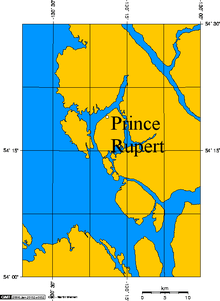
Kaien Island

Kaien Island is a Canadian island on the coast of British Columbia, just north of the mouth of the Skeena River and to the south of the Alaska Panhandle. The city of Prince Rupert, British Columbia is situated on it. The city and island are both located within the Skeena-Queen Charlotte Regional District and are part of the North Coast region.
Casey Point is located on the western extremity of the island at 54°16′33″N 130°21′36″W / 54.27583°N 130.36000°W,[1] facing Digby Island, was the site of one of the coastal defence installations to protect the BC Coast during World War II. Another such installation was at Seal Cove on the island's northern tip at 54°19′54″N 130°16′53″W / 54.33167°N 130.28139°W.[2]
See also
- Prince Rupert Harbour
References
External links
Coordinates: 54°16′58″N 130°18′12″W / 54.28274°N 130.30341°W