Kagbeni, Mustang
| Kagbeni कागबेनी | |
|---|---|
| Village Development Committee | |
|
Mud houses in Kagbeni village | |
 Kagbeni Location in Nepal | |
| Coordinates: 28°50′12″N 83°46′59″E / 28.83667°N 83.78306°ECoordinates: 28°50′12″N 83°46′59″E / 28.83667°N 83.78306°E | |
| Country |
|
| Zone | Dhawalagiri Zone |
| District | Mustang District |
| Population (1991) | |
| • Total | 1,200 |
| Time zone | Nepal Time (UTC+5:45) |


The Kali Gandaki River and rice fields near Kagbeni
Kagbeni is a village in Upper Mustang, Nepal, located in the valley of the Kali Gandaki River. Administratively, Kagbeni is a Village Development Committee in Mustang District in the Dhawalagiri Zone of northern Nepal. At the time of the 1991 Nepal census it had a population of 1200 people residing in 260 individual households. [1] It lies on the trail from Jomsom to the royal capital Lo Manthang, near the junction with the trail to Muktinath.

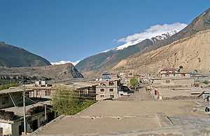
Panoramic view of Kagbeni
References
- ↑ "Nepal Census 2001", Nepal's Village Development Committees (Digital Himalaya), retrieved 13 April 2015.
External links
| ||||||||||||||||

| Wikimedia Commons has media related to Kagbeni. |