Kadena, Okinawa
| Kadena Okinawan: Kadina | |||
|---|---|---|---|
| Town | |||
|
Downtown Kadena | |||
| |||
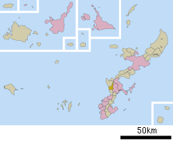
 Location of Kadena in Okinawa Prefecture | |||
 Kadena
| |||
| Coordinates: 26°21′42″N 127°45′19″E / 26.36167°N 127.75528°ECoordinates: 26°21′42″N 127°45′19″E / 26.36167°N 127.75528°E | |||
| Country | Japan | ||
| Region | Kyushu | ||
| Prefecture | Okinawa Prefecture | ||
| District | Nakagami | ||
| Government | |||
| • Mayor | Hiroshi Toyama | ||
| Area | |||
| • Total | 15.04 km2 (5.81 sq mi) | ||
| Dimensions | |||
| • Length | 8 km (5 mi) | ||
| • Width | 5 km (3 mi) | ||
| Population (January 2013) | |||
| • Total | 13,823 | ||
| • Density | 920/km2 (2,400/sq mi) | ||
| Time zone | Japan Standard Time (UTC+9) | ||
| Tree | Kuroki Ebenales | ||
| Flower | Hibiscus | ||
| Phone number | 098-956-1111 | ||
| Address |
588 Kadena, Kadena-chō, Nakagami-gun, Okinawa 904-0293 | ||
| Website |
www | ||

Japan National Route 58 at Kadena
Kadena (嘉手納町 Kadena-chō, Okinawan: Kadina) is a town located in Nakagami District, Okinawa Prefecture, Japan.[1]
As of 2013, the town had an estimated population of 13,823 and a density of 920 persons per km². The total area is 15.04 square kilometres (5.81 sq mi). Approximately 85% of the town is controlled by the US Government including Kadena Air Base, the second-largest base in the United States Air Force.[2][3]
Geography
Kadena faces the East China Sea to the west.[1]
Neighboring municipalities
Kadena borders three other municipalities in Okinawa Prefecture.
Economy
The economy of Kadena is largely dependent on the presence of Kadena Air Force Base. The town otherwise produces a small amount of pineapples and sugarcane.[3]
References
- ↑ 1.0 1.1 1.2 "嘉手納町" [Kadena]. Nihon Rekishi Chimei Taikei (in Japanese). Tokyo: Shogakukan. 2013. OCLC 173191044. Retrieved 2013-08-19.
- ↑ 統計情報 [Statistical Information] (in Japanese). Kadena, Okinawa Prefecture, Japan: Town of Kadena. 2013. Retrieved 2013-08-19.
- ↑ 3.0 3.1 "Kadena". Encyclopedia of Japan. Tokyo: Shogakukan. 2013. OCLC 56431036. Retrieved 2013-08-19.
External links
| Wikimedia Commons has media related to Kadena, Okinawa. |
- Kadena official website (Japanese)
