Kařez
| Kařez | |||
|---|---|---|---|
| Municipality | |||
| |||
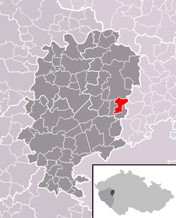 Location in Rokycany District | |||
 Kařez Location in the Czech Republic | |||
| Coordinates: 49°49′17″N 13°47′0″E / 49.82139°N 13.78333°ECoordinates: 49°49′17″N 13°47′0″E / 49.82139°N 13.78333°E | |||
| Country |
| ||
| Region | Plzeň | ||
| District | Rokycany | ||
| Area | |||
| • Total | 5.86 km2 (2.26 sq mi) | ||
| Elevation | 452 m (1,483 ft) | ||
| Population (2006) | |||
| • Total | 570 | ||
| • Density | 97/km2 (250/sq mi) | ||
| Postal code | 338 08 | ||
| Website | http://www.karez.rokycansko.cz | ||

Kařez is a village and municipality (obec) in Rokycany District in the Plzeň Region of the Czech Republic.
The municipality covers an area of 5.86 square kilometres (2.26 sq mi), and has a population of 570 (as at 3 July 2006).
Kařez lies approximately 17 kilometres (11 mi) north-east of Rokycany, 31 km (19 mi) east of Plzeň, and 55 km (34 mi) south-west of Prague.
References
| Wikimedia Commons has media related to Kařez. |