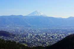
Kōfu
| Kōfu 甲府市 | ||
|---|---|---|
| Special city | ||
| Kofu City | ||
 | ||
| ||
 Location of Kōfu in Yamanashi Prefecture | ||
 Kōfu Location in Japan | ||
| Coordinates: 35°40′N 138°34′E / 35.667°N 138.567°ECoordinates: 35°40′N 138°34′E / 35.667°N 138.567°E | ||
| Country | Japan | |
| Region | Chūbu (Tōkai) | |
| Prefecture | Yamanashi Prefecture | |
| Government | ||
| • Mayor | Masanobu Miyajima (since February 2003) | |
| Area | ||
| • Total | 212.41 km2 (82.01 sq mi) | |
| Population (May 1, 2011) | ||
| • Total | 197,540 | |
| • Density | 929.99/km2 (2,408.7/sq mi) | |
| Time zone | Japan Standard Time (UTC+9) | |
| Symbols | ||
| - Tree | Quercus | |
| - Flower | Dianthus | |
| - Bird | Common Kingfisher | |
| Address |
2-17-1 Aioi, Kofu-shi, Yamanashi-ken 400-8585 | |
| Phone number | 055-237-1161 | |
| Website |
www | |

Kōfu (甲府市 Kōfu-shi) is the capital city of Yamanashi Prefecture in Japan.
As of May 1, 2011, the city has an estimated population of 197,540, with 85,794 households and a population density of 929.99 persons per km². The total area is 212.41 km².
History

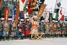
Kōfu's name means "capital of Kai Province". During the Sengoku period, it was the stronghold of Takeda Shingen.
Centuries ago the area which today is referred to as Yamanashi Prefecture was known as Kai Province. At that time the geographical denomination of ken (prefecture), was not yet in use, and the area was categorized as a fu. Located in the center of Kai, Kōfu's name was derived from a combination of kanji used in both Kai and fu. Alternate pronunciation of the characters resulted in the modern name of Kōfu.
Archaeologists have discovered evidence of human settlement in the Kōfu area dating back as far as 6000 years BCE. However, the town of Kōfu was not formally established until 1519.
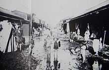
During World War II, much of the city was destroyed by United States Army Air Forces B-29 Superfortress bombers during a major air raid during the night of 6 July 1945.[1]
Kōfu is designated as one of the special cities of Japan. On March 1, 2006, Kōfu, with a population of 193,795, absorbed the town of Nakamichi (from Higashiyatsushiro District), and the northern part of the village of Kamikuishiki (from Nishiyatsushiro District) increasing the population to 201,184.
Climate
Kōfu has the typical Honshū humid subtropical climate, though it is less wet than either the south or Sea of Japan coast due to its location in a shielded mountain valley. Temperature ranges are noticeably greater than in coastal regions: in 2004 Kōfu reached a temperature of 40 °C (104 °F) previously almost unknown in Japan, and it has fallen below 0 °C (32 °F) as early as 26 October,[2] which is about a month before the earliest freezing temperatures in such coastal cities as Kanazawa or Tokyo.
| Climate data for Kōfu, Yamanashi (1981~2010) | |||||||||||||
|---|---|---|---|---|---|---|---|---|---|---|---|---|---|
| Month | Jan | Feb | Mar | Apr | May | Jun | Jul | Aug | Sep | Oct | Nov | Dec | Year |
| Record high °C (°F) | 20.2 (68.4) |
25.4 (77.7) |
28.8 (83.8) |
33.1 (91.6) |
34.3 (93.7) |
38.1 (100.6) |
40.4 (104.7) |
39.8 (103.6) |
38.0 (100.4) |
33.8 (92.8) |
29.6 (85.3) |
24.9 (76.8) |
40.4 (104.7) |
| Average high °C (°F) | 8.8 (47.8) |
10.3 (50.5) |
14.2 (57.6) |
20.4 (68.7) |
24.6 (76.3) |
27.3 (81.1) |
30.9 (87.6) |
32.5 (90.5) |
28.0 (82.4) |
21.9 (71.4) |
16.4 (61.5) |
11.2 (52.2) |
20.5 (68.9) |
| Average low °C (°F) | −2.4 (27.7) |
−1 (30) |
2.7 (36.9) |
8.3 (46.9) |
13.3 (55.9) |
17.9 (64.2) |
21.8 (71.2) |
22.8 (73) |
19.1 (66.4) |
12.3 (54.1) |
5.5 (41.9) |
−0.2 (31.6) |
10.0 (50) |
| Record low °C (°F) | −19.5 (−3.1) |
−17.2 (1) |
−11.4 (11.5) |
−4.6 (23.7) |
−0.6 (30.9) |
5.4 (41.7) |
12.6 (54.7) |
13.2 (55.8) |
6.0 (42.8) |
−1.8 (28.8) |
−6 (21) |
−11.7 (10.9) |
−19.5 (−3.1) |
| Average precipitation mm (inches) | 40.2 (1.583) |
46.1 (1.815) |
87.9 (3.461) |
77.7 (3.059) |
86.3 (3.398) |
122.5 (4.823) |
132.6 (5.22) |
149.5 (5.886) |
180.3 (7.098) |
125.2 (4.929) |
54.9 (2.161) |
32.1 (1.264) |
1,135.3 (44.697) |
| Average snowfall cm (inches) | 13 (5.1) |
10 (3.9) |
4 (1.6) |
0 (0) |
0 (0) |
0 (0) |
0 (0) |
0 (0) |
0 (0) |
0 (0) |
0 (0) |
1 (0.4) |
28 (11) |
| Avg. precipitation days (≥ 0.5 mm) | 4.9 | 5.7 | 9.8 | 8.9 | 9.7 | 12.1 | 12.5 | 10.1 | 11.2 | 9.4 | 6.3 | 4.2 | 104.8 |
| Avg. snowy days | 4.5 | 3.1 | 0.9 | 0.1 | 0.0 | 0.0 | 0.0 | 0.0 | 0.0 | 0.0 | 0.0 | 0.6 | 9.2 |
| Average relative humidity (%) | 57 | 54 | 56 | 58 | 64 | 71 | 73 | 71 | 72 | 71 | 68 | 61 | 64.7 |
| Mean monthly sunshine hours | 204.8 | 189.9 | 198.7 | 202.0 | 196.3 | 148.9 | 164.1 | 197.3 | 142.2 | 160.9 | 176.6 | 201.3 | 2,183 |
| Source #1: Japan Meteorological Agency[3] | |||||||||||||
| Source #2: Japan Meteorological Agency (records)[4] | |||||||||||||
Education
- University of Yamanashi
- Yamanashi Prefectural University
- Yamanashi Gakuin University
- Yamanashi Eiwa College
- Yamanashi Eiwa College
Transportation
Rail
- East Japan Railway Company – Chūō Main Line
- Central Japan Railway Company - Minobu Line
- Kokubo - Kai-Sumiyoshi - Minami-Kōfu - Zenkōji - Kanente - Kōfu
Road
- Chūō Expressway
- National Route 20
- National Route 52
- National Route 140
- National Route 137
- National Route 358
- National Route 411
Notable places
- Kai-Zenkō temple
- Maizuru Castle Park
- Takeda Shrine
- Yumura Spa
- Yamanashi Science Museum
- Shōsen Kyō (Valley)
Notable people
- Banjō Ginga – voice actor
- Hideo Hagiwara – woodblock print artist
- Tsuneo Horiuchi – former manager of Yomiuri Giants baseball team
- Takao Kajimoto – former professional baseball player and sports announcer
- Yoshinobu Kanemaru – professional wrestler
- Hidetoshi Nakata - football player who last played with the Bolton Wanderers in the Premier League, but has since retired following the 2006 World Cup.
- Naoko Takeuchi – manga artist, creator of Sailor Moon and other comics.
- Fujizakura Yoshimori – former sumo wrestler
Sport
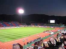
A J-League football team, Ventforet Kofu is based in Kōfu. They currently play in the J. League Division 1, and their home ground is the Kose Sports Stadium.
Sister cities
-
 Des Moines, Iowa, USA, since August 16, 1958
 -
 Pau, Pyrénées-Atlantiques, France, since August 18, 1975
 - Lodi, California, USA, since April 11, 1981[5]
-
 Chengdu, China, since September 27, 1984
 -
 Yamatokoriyama, Nara, Japan, since January 22, 1992
 -
 Cheongju, South Korea, since September 26, 2002
References
- ↑ Ijiri, Toshiyuki (1991). Paul Rusch. Cincinnati, Ohio: Forward Movement Publications. p. 167.
- ↑ http://www.data.jma.go.jp/obd/stats/etrn/view/rank_s.php?prec_no=19&prec_ch=%8B%FA%98H%8Ex%92%A1&block_no=47638&block_ch=%8B%FA%98H&year=&month=10&day=&view= 観測史上1~10位の値(10月としての値)
- ↑ "平年値(年・月ごとの値)". Japan Meteorological Agency. Retrieved 2011-11-26.
- ↑ "観測史上1~10位の値(年間を通じての値)". Japan Meteorological Agency. Retrieved 2011-11-26.
- ↑ "Consolidation of Local Governments in Japan and Effects on Sister City Relationships," Consulate General of Japan, San Francisco
External links
| Wikimedia Commons has media related to Kofu, Yamanashi. |
- Kōfu City official website
- Yamanashi International Association
- teacher website-English
- Yamanashi teacher's website-English
| ||||||||||||||||||||||||||||
| ||||||||||||||||||||||||