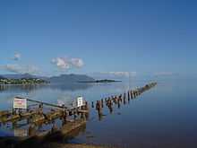
Kāneʻohe Bay

Kāneʻohe Bay, at 45 km², is the largest sheltered body of water in the main Hawaiian Islands. This reef-dominated embayment constitutes a significant scenic and recreational feature along the windward (northeast) coast of the Island of Oʻahu. The largest population center on Kāneʻohe Bay is the town of Kāneʻohe.
The Bay is approximately 8 mi (12.8 km) long and 2.7 mi (4.3 km) broad, with a mouth opening of about 4.6 mi (7.4 km) and maximum depth of 40 ft (12 m) in the dredged channel. Features unique in the main Hawaiian Islands include one of only two barrier reefs (the other being the 27 mile barrier reef of Molokaʻi island) and extensive development of shoaling coral reefs within a large lagoon. Two navigable channels cut across the northern and southern ends of the barrier reef. The deeper, northern channel, located off Kualoa Regional Park, provides entrance from the North Pacific Ocean to a ship channel dredged the length of the lagoon between 1939 and 1945. The lagoon contains extensive patch and fringing reefs and its southern end is partly enclosed by the Mokapu Peninsula. This peninsula is occupied by Marine Corps Base Hawaii. The bay is located at coordinates 21°27′35″N 157°48′15″W / 21.45972°N 157.80417°WCoordinates: 21°27′35″N 157°48′15″W / 21.45972°N 157.80417°W.[1]


There are fived named islands or islets within Kāneʻohe Bay. A sand bar (Ahu o Laka), Kapapa, and Kekepa (Turtleback Rock) are all exposed features (islets) on the barrier reef. Two islands within Kāneʻohe Bay are prominent: Mokoliʻi (Chinaman's Hat) and Moku o Loʻe (Coconut Island), the largest of the five. Mokoliʻi is a volcanic remnant at the very north end of the Bay, site of former Kualoa Airfield. The community on the northern side is called Waikane, or North Koʻolaupoko.
Coconut Island is an isolated volcanic remnant located in the southwest part of the bay. Coconut Island is owned by the State of Hawaiʻi and home to the University of Hawaiʻi,[2] and Pauley-Pagen Laboratory (SOEST). Coconut Island was used for the opening sequence of the television program Gilligan's Island.[3]
In August of 2010, "Pirates of the Caribbean 4" was filmed on the bay.[4]
Geologically, Kāneʻohe Bay forms part of a former caldera of the Koʻolau volcano. In prehistory, most of the volcano catalysmically slid into the Pacific Ocean, leaving behind only the Range and the Bay.
References
- ↑ U.S. Geological Survey Geographic Names Information System: Kāne‘ohe Bay
- ↑ "Hawaiʻi Institute of Marine Biology (HIMB)". Retrieved 2010-04-14.
- ↑ "Kayaking and Snorkeling: He'eia State Park". He'eia Learning Center. Retrieved September 14, 2011.
- ↑ "'Pirates of the Caribbean 4' draws crowds to Kaneohe Bay, Hawaii". Retrieved 6 March 2013.
|first1=missing|last1=in Authors list (help)
External links
- Paul L. Jokiel. "Jokiel's Illustrated Scientific Guide to Kāneʻohe Bay, Oʻahu". Retrieved 2010-04-14.
- Chinaman's Hat
- "Kaneohe Bay... Going Back to Old Hawaii". Hawaii Beach Combers web site. Retrieved 2010-04-14. Estuarine Area
- Anchoring at Kāne‘ohe Sand Bar