Juruena River
| Juruena River | |
 | |
| Country | Brazil |
|---|---|
| Tributaries | |
| - left | Vermelho River, Juína-Mirim River, Camararé River, Juína River |
| - right | São Tomé River, São João da Barra River, Arinos River, Do Sangue River, Papagaio River |
| Source | |
| - location | Parecis plateau, Mato Grosso, Brazil |
| Mouth | Tapajós River |
| - location | Amazonas–Mato Grosso border, Brazil |
| - coordinates | 7°21′01″S 58°08′18″W / 7.35028°S 58.13833°WCoordinates: 7°21′01″S 58°08′18″W / 7.35028°S 58.13833°W |
| Length | 960 km (597 mi) [1] |
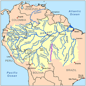 Amazon Basin with the Juruena River highlighted
| |
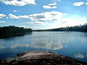
The Juruena River (Portuguese: Rio Juruena) is a 1,240 km (770 mi) long river in west-central Brazil, in the state of Mato Grosso. It originates in the Parecis plateau. For the last 190 km (120 mi) of its lower part the river becomes the border between the states Mato Grosso and Amazonas. It finally joins the Teles Pires river to form the Tapajós river, which is one of the biggest tributaries to the Amazon River. The Juruena River is not navigable due to its many waterfalls and rapids.[2][1]
The river is the site of the Juruena National Park as well as the Salto Augusto Falls. Juruena National Park was created on June 5, 2006, and covers 19,000 km2 (7,300 sq mi).
References
- ↑ 1.0 1.1 Ziesler, R.; Ardizzone, G.D. (1979). "Amazon River System". The Inland waters of Latin America. Food and Agriculture Organization of the United Nations. ISBN 92-5-000780-9. Archived from the original on 8 November 2014.
- ↑ "Juruena River". Encyclopaedia Britannica. Encyclopaedia Britannica Inc. 2015. Retrieved 2015-02-13.