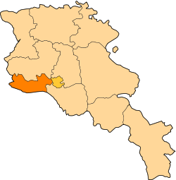
Jrarat, Armavir
Coordinates: 40°04′17″N 44°15′47″E / 40.07139°N 44.26306°E
| Jrarat Ջրառատ | |
|---|---|
 Jrarat | |
| Coordinates: 40°04′17″N 44°15′47″E / 40.07139°N 44.26306°E | |
| Country | Armenia |
| Marz (Province) | Armavir |
| Population (2008) | |
| • Total | 2,833 |
| Time zone | (UTC+4) |
Jrarat (Armenian: Ջրառատ) formerly known as Gharkhun or Verin Gharkhun, is a village in the Armavir Province of Armenia. It has a large poultry industry and nearby is a piece of land reserved for the cochineal dye beetles, Porphyrophora hamelii. [1]
In addition to the 2,833 people in the town, the Jrarrat Poultry Farm has an additional 1,165 residents (2001 census) in its workers' housing, bringing the population of the area to 4,000.
References
- ↑ Kiesling, Rediscoving Armenia, p. 40, available online at the US embassy to Armenia's website
- Jrarat, Armavir at GEOnet Names Server
- World Gazeteer: Armenia – World-Gazetteer.com
- Report of the results of the 2001 Armenian Census, National Statistical Service of the Republic of Armenia
- Brady Kiesling, Rediscovering Armenia, p. 40; original archived at Archive.org, and current version online on Armeniapedia.org.
