Jorethang
| Jorethang |
|---|
|
City |
 |
|
Location in Sikkim, India |
|
Coordinates: 27°12′N 88°21′E / 27.2°N 88.35°E / 27.2; 88.35Coordinates: 27°12′N 88°21′E / 27.2°N 88.35°E / 27.2; 88.35 |
| Country |
 India India |
|---|
| State |
Sikkim |
|---|
| District |
South Sikkim |
|---|
| Elevation |
322 m (1,056 ft) |
|---|
| Population (2006) |
|---|
| • Total |
3,596 |
|---|
| Languages |
|---|
| • Official |
Nepali, Bhutia, Lepcha, Limbu, Newari, Rai, Gurung, Mangar, Sherpa, Tamang and Sunwar |
|---|
| Time zone |
IST (UTC+5:30) |
|---|
| Vehicle registration |
SK-04 |
|---|
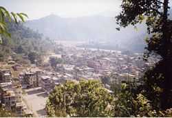
Jorethang (Nepali : जोरेथाङ) is a major town in South Sikkim district in the Indian state of Sikkim. The town is situated at an altitude of about 300 m above sea level and has a temperate climate. Jorethang lies on the Rangeet River, a tributary of the River Teesta. Jorethang lies on the way to Pelling from Darjeeling, Siliguri and Kalimpong. The route is well connected by buses and jeeps. It is particularly known for its annual fair where people from all over the state and nearby places come to visit.
Demographics

Jorethang, Sikkim, India
As of 2001 India census,[1] Jorethang had a population of 2968. Males constitute 53% of the population and females 47%. Jorethang has an average literacy rate of 81%, higher than the national average of 59.5%: male literacy is 86%, and female literacy is 76%. In Jorethang, 10% of the population is under 6 years of age.
References
External links
|
|---|
| | | | Topics | |
|---|
| | Districts | |
|---|
| | Towns | |
|---|
| | Rivers | |
|---|
| | Lakes | |
|---|
| | Glaciers | |
|---|
| | See also | |
|---|
|


