Jones-Confluence Point State Park
| Jones-Confluence Point State Park | |
| Missouri State Park | |
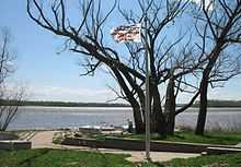
 Confluence Point with the Mississippi on the left and the Missouri on the right | |
| Country | United States |
|---|---|
| State | Missouri |
| County | St. Charles County |
| City | West Alton |
| Coordinates | 38°49′3″N 90°7′11″W / 38.81750°N 90.11972°WCoordinates: 38°49′3″N 90°7′11″W / 38.81750°N 90.11972°W |
| Area | 1,121.43 acres (454 ha) [1] |
| Established | 2001 |
| Management | Missouri Department of Natural Resources |
 Location in Missouri
| |
| Website: Jones-Confluence Point State Park | |
Edward "Ted" and Pat Jones-Confluence Point State Park is a Missouri state park located on the north side of the Missouri River at its confluence with the Mississippi River,[2] approximately 8 miles north of the St. Louis Arch. The park was opened May 9, 2004, and includes 1,121 acres (454 ha) of shoreline and bottomland. The park is part of the Confluence Greenway.[3] The lands within the park were purchased in 2001 by Western Rivers Conservancy and conveyed to the Missouri Department of Natural Resources and the Metropolitan Parks and Recreation District to be managed as a state park.[4]
The Lewis and Clark Expedition began at this confluence in 1804. The Missouri Department of Natural Resources manages the park and plans to "restore a natural floodplain reminiscent of what Lewis and Clark might have seen along the lower Missouri River."[5] The area is noted as a great birdwatching site.[5] Trails are under construction and will eventually connect with the Katy Trail which runs for 225 miles (362 km) across Missouri to the west of the park.
The park is named for Edward Jones Investments heir Edward D. "Ted" Jones and his wife Pat Jones who donated $2.2 million for the Katy Trail. It stands opposite the Columbia Bottom Conservation Area.
References
- ↑ "State parks...estimated acres" (PDF). Revised Statewide Comprehensive Outdoor Recreation Plan: 2008-2012. Missouri Department of Natural Resources. pp. 142–143. Retrieved September 9, 2014.
- ↑ "Jones-Confluence Point State Park". Missouri State Parks. Missouri Department of Natural Resources. Retrieved September 29, 2014.
- ↑ "Confluence Greenway". Great Rivers Greenway. Retrieved September 29, 2014.
- ↑ "Missouri-Mississippi Confluence". Western Rivers Conservancy. Retrieved September 29, 2014.
- ↑ 5.0 5.1 "General Information: Jones-Confluence Point State Park". Missouri State Parks. Missouri Department of Natural Resources. Retrieved September 29, 2014.
External links
- Jones-Confluence Point State Park Missouri Department of Natural Resources