Johnston Creek (Alberta)
| Johnston Creek | |
|---|---|
|
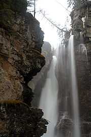
Upper Falls in Johnston Canyon | |
| Origin |
Badger Pass, Pulsatilla Pass 51°24′33″N 115°53′45″W / 51.40911°N 115.89576°W |
| Mouth |
Bow River 51°14′29″N 115°51′10″W / 51.24148°N 115.85289°W |
| Basin countries |
|
| Source elevation | 2,500 meters (8,200 ft) |
| Mouth elevation | 1,440 meters (4,720 ft) |
Johnston Creek is a tributary of the Bow River in Canada's Rocky Mountains. The creek is located in Banff National Park.
Course
Johnston Creek originates north of Castle Mountain in a glacial valley southwest of Badger Pass and south of Pulsatilla Pass, at an elevation of 2,500 meters (8,200 ft). The creek flows southeast between Helena Ridge and the Sawback Range, and then south through a gorge known as Johnston Canyon. The stream empties into the Bow River, south of Castle Mountain, between Banff and Lake Louise, at an elevation of 1,440 meters (4,720 ft).
Johnston Canyon
As Johnston Creek approaches the Bow River, it flows through a large canyon formed by erosion over thousands of years. The creek has cut through the limestone rock to form sheer canyon walls, as well as waterfalls, tunnels, and pools.
A popular hiking trail follows the canyon and leads to a meadow within the Johnston Valley above the canyon. The first part of the trail consists of a constructed walkway with safety rails and bridges, while the last part of the trail is natural and more rugged. Within the meadow are the Ink Pots, which are six blue-green spring-fed pools.
Ice climbing is a popular activity on the frozen waterfalls in winter.
A tourist lodge and large parking area is located at the foot of the canyon, close to the creek mouth, along the Bow Valley Parkway (Highway 1A).
Gallery
-
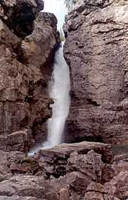
Cascade in Johnston Canyon
-
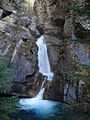
Lower Falls in Johnston Canyon
-
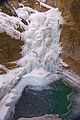
Frozen Lower Falls in Johnston Canyon
-
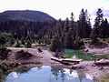
Ink Pots
See also
References
- Patton, B and Robinson, B. The Canadian Rockies Trail Guide. Devil's Head Press Ltd. Canmore. 1978. ISBN 0-9690806-0-3
External links
| Wikimedia Commons has media related to Johnston Canyon. |
- Banff.com - Johnston Canyon
- Johnston Canyon Trail to Ink Pots
| ||||||||||||||||||||||||||||
Coordinates: 51°14′45″N 115°50′28″W / 51.24583°N 115.84111°W