Jimenez, Misamis Occidental
| Jimenez | ||
|---|---|---|
| Municipality | ||
| ||
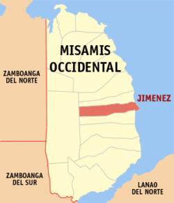 Map of Misamis Occidental with Jimenez highlighted | ||
.svg.png) Jimenez Location within the Philippines | ||
| Coordinates: 08°20′N 123°50′E / 8.333°N 123.833°ECoordinates: 08°20′N 123°50′E / 8.333°N 123.833°E | ||
| Country | Philippines | |
| Region | Northern Mindanao (Region X) | |
| Province | Misamis Occidental | |
| District | 1st district of Misamis Occidental | |
| Founded | April 7, 1900 | |
| Barangays | 24 | |
| Government[1] | ||
| • Mayor | Rosario Kais Balais | |
| Area[2] | ||
| • Total | 81.43 km2 (31.44 sq mi) | |
| Population (2010)[3] | ||
| • Total | 25,234 | |
| • Density | 310/km2 (800/sq mi) | |
| Time zone | PST (UTC+8) | |
| ZIP code | 7204 | |
| Dialing code | 88 | |
| Income class | 3rd | |

Jimenez is a third class municipality in the province of Misamis Occidental, Philippines. According to the 2010 census, it has a population of 25,234 people.[3]
Within the predominantly Catholic town lies the Church of Saint John the Baptist which is one of the oldest monuments in the Philippines. Many Jimeneznons live outside the country but have retained close ties to the town, with "balikbayans" offering community service and philanthropy, and others taking up residence upon retirement abroad.
Barangays
Jimenez is politically subdivided into 24 barangays.[2]
- Adorable
- Butuay
- Carmen
- Corrales
- Dicoloc
- Gata
- Guintomoyan
- Malibacsan
- Macabayao
- Matugas Alto
- Matugas Bajo
- Mialem
- Naga (Pob.)
- Palilan
- Nacional (Pob.)
- Rizal (Pob.)
- San Isidro
- Santa Cruz (Pob.)
- Sibaroc
- Sinara Alto
- Sinara Bajo
- Seti
- Tabo-o
- Taraka (Pob.)
Demographics
| Population census of Jimenez | ||
|---|---|---|
| Year | Pop. | ±% p.a. |
| 1990 | 20,589 | — |
| 1995 | 21,434 | +0.76% |
| 2000 | 23,212 | +1.72% |
| 2007 | 24,340 | +0.66% |
| 2010 | 25,234 | +1.32% |
| Source: National Statistics Office[3] | ||
Education
Jimenez has three major high schools including School of Saint John the Baptist, Jimenez Bethel Institute, and a public high school located in barangay Corrales.
List of Cultural Properties of the Philippines in Jimenez
| Cultural Property wmph identifier |
Site name | Description | Province | City/Municipality | Address/Location | Coordinates | Image |
|---|---|---|---|---|---|---|---|
| Apolinar Jungao Razo House | Misamis Occidental | Jimenez | 8°20′01″N 123°50′40″E / 8.333659°N 123.844418°E |  | |||
| Bacarro Printing Press | Misamis Occidental | Jimenez | 8°20′06″N 123°50′28″E / 8.334951°N 123.841198°E |  | |||
| Balbino and Escobia Angus House | Misamis Occidental | Jimenez | 8°20′02″N 123°50′29″E / 8.333798°N 123.841446°E |  | |||
| Benito Lim and Marcelina Cabalog House | Misamis Occidental | Jimenez | Calderon cor. Sen. Ozamiz Sts. | 8°20′08″N 123°50′23″E / 8.335584°N 123.839667°E |  | ||
| Casa de Ozamiz | Misamis Occidental | Jimenez | 8°20′03″N 123°50′35″E / 8.334125°N 123.842983°E | 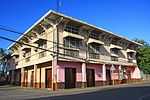 | |||
| Cayetano Yu and Usebia Larilin House | Misamis Occidental | Jimenez | 8°20′03″N 123°50′30″E / 8.334243°N 123.841746°E | 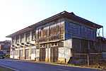 |
References
- ↑ "Official City/Municipal 2013 Election Results". Intramuros, Manila, Philippines: Commission on Elections (COMELEC). 1 July 2013. Retrieved 5 September 2013.
- ↑ 2.0 2.1 "Province: MISAMIS OCCIDENTAL". PSGC Interactive. Makati City, Philippines: National Statistical Coordination Board. Retrieved 14 July 2014.
- ↑ 3.0 3.1 3.2 "Total Population by Province, City, Municipality and Barangay: as of May 1, 2010" (PDF). 2010 Census of Population and Housing. National Statistics Office. Retrieved 14 July 2014.
External links
- Philippine Standard Geographic Code
- Philippine Census Information
- Local Governance Performance Management System
 |
Panaon | | ||
| Don V. Chiongbian | |
Iligan Bay | ||
| ||||
| | ||||
| Sinacaban |
| ||||||||||||||