Jhelum Tehsil
| Jhelum Tehsil | |
|---|---|
| Tehsil | |
|
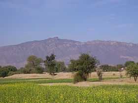
Tilla Jogian, the highest peak in Jhelum Tehsil | |
| Country | Pakistan |
| Region | Punjab |
| District | Jhelum District |
| Towns | 1 |
| Union councils | 17 |
| Time zone | PKT (UTC+5) |
Jhelum Tehsil is an administrative subdivision of Jhelum District in Punjab province, Pakistan. The tehsil is subdivided into 27 Union Councils and is headquartered at the city of Jhelum.[1]
History
The Imperial Gazetteer of India,[2] compiled over a century ago during British rule, describes the tehsil as follows:
"Eastern tahsīl of Jhelum District, Punjab, lying between 32° 39' and 33° 15' N. and 73° 9' and 73° 48' E, with an a of 888 square miles. It is bounded,, the east and southeast by the Jhelum river, which divides it from Kashmir and Gujrāt District. The population in 1901, was 170,978, compared with 177,046 in 1891. The headquarters are at the town of Jhelum (population, 14,951). It also contains 433 villages.
The land revenue and cesses in 1903-4 amounted to 270,000. The tahsīl is traversed from south-west to north-east by two spurs of the Salt Range, the more easterly of which culminates in the peak of Tilla. Between this and the Jhelum river is an almost level alluvial plain of great fertility; while between the two spurs the country is seemed with ravines The fort of Rohtas is of historical interest."
Union Councils
Jhelum Tehsil is subdivided into Union Councils Badlot, Boken, Chak Khasa, Chotala, Darapur, Dhanyala, Garh Mahal, Kala Gujran, Khukha, Kotla Faqir, Madu Kalas, Monan, Mughalabad, Nakka Khurd, Nara, Pandori, Sanghoi and Sohan.
Colleges and schools
- Army Public School and College Jhelum Cantt
- FG Intermediat College Jhelum Cantt
- Fauji Foundation Model School & College,Jhelum Cantt
- Cantonment Board CMB Model Jhelum
- Govt. Degree College, Jhelum
- Govt. College. G.T. Road, Jhelum
- Govt. College for Women, Jhelum
- Govt. College of Commerce, Bilal Town, Jhelum
- Research Girls College Kala Gujran Jhelum
- Jinnah Law College Near Kutcheri, Jhelum
- M. A. Jinnah College of Commerce & Computer Science, Jhelum
- PICS, Bilal town Jhelum
- Presentation convent high school for girls, Jhelum Cantt
- Jhelum Homeopathic Medical College,GT Road Jada, Jhelum
- SLS College, Jhelum
- National Reformers School Mohallah Khansama Jhelum
Notable residents
- Muhammad Akram, Nishan-e-Haider
- Tariq Kamal Khan, former Chief of Naval Staff Pakistan Navy
- Raja Azmat kamal Khan Gakhar Ex- District Chairman Jhelum
- Syed Manzoor ul Hassan Hashmi, Wing Commander Pakistan Airforce, Sitara-e-Jurrat Bar
- Chaudhry Farrukh Altaf, Ex- District Nazim Jhelum District[3][4]
- Ghafer Shahzad, First PhD in Architecture from University of Engineering & Technology, Lahore
References
- ↑ Tehsils & Unions in the District of Jhelum - Government of Pakistan
- ↑ Jhelum Tahsīl - Imperial Gazetteer of India, v. 14, p. 159.
- ↑ Wajahat Ijaz (22 October 2002). "Their way to parliament passed through Nazim's office". Pakistan Dawn.
- ↑ "Iftikhar Ch. urges lawyers to remain steadfast in their struggle to ensure rule of law". Pak Tribune. 6 May 2007.
External links

| ||||||||||||||||||||||||||||||||||||||||||||||||||||||||||||||||||||||||||||||||||||||||||||||||||||||||||||||||||||||||||||||||||||||||||||||||||||||