Jettenbach, Rhineland-Palatinate
| Jettenbach | ||
|---|---|---|
| ||
 Jettenbach | ||
Location of Jettenbach within Kusel district 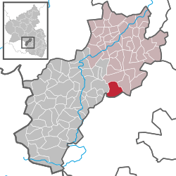 | ||
| Coordinates: 49°32′08″N 7°33′21″E / 49.53556°N 7.55583°ECoordinates: 49°32′08″N 7°33′21″E / 49.53556°N 7.55583°E | ||
| Country | Germany | |
| State | Rhineland-Palatinate | |
| District | Kusel | |
| Municipal assoc. | Lauterecken-Wolfstein | |
| Government | ||
| • Mayor | Bernd Ginkel | |
| Area | ||
| • Total | 10.24 km2 (3.95 sq mi) | |
| Population (2012-12-31)[1] | ||
| • Total | 843 | |
| • Density | 82/km2 (210/sq mi) | |
| Time zone | CET/CEST (UTC+1/+2) | |
| Postal codes | 66887 | |
| Dialling codes | 06385, 06387 | |
| Vehicle registration | KUS | |
| Website | www.jettenbach.de | |

Jettenbach is an Ortsgemeinde – a municipality belonging to a Verbandsgemeinde, a kind of collective municipality – in the Kusel district in Rhineland-Palatinate, Germany. It belongs to the Verbandsgemeinde Lauterecken-Wolfstein.
Geography
Location
The municipality lies in the North Palatine Uplands. The original village of Jettenbach grew in the valley of the like-named brook, the Jettenbach, and quite early on, a mediaeval linking road running from Landstuhl to Trier, and likewise the ridge right nearby running parallel to the brook, were built up. In the south looms the Spannagelberg (449.5 m above sea level) and in the north is found the Potschberg (formerly 492 m above sea level). South of the village, the Rutzenbach and the Selchenbach flow together to form the Jettenbach, which then flows north through the village, later emptying into the Talbach near Eßweiler. In the southeast, the ridge of the Imberg (almost 450 m above sea level) borders on the valley. The village’s mean elevation is reckoned at 355.6 m above sea level. The municipal area measures 1 025 ha, of which 69 ha is used for dwelling or transport, 593 ha is under agricultural use and 322 ha is made up of meadows or woodland.[2]
Neighbouring municipalities
Jettenbach borders in the north on the municipality of Eßweiler, in the east on the municipality of Rothselberg, in the southeast on the municipality of Kollweiler, in the southwest on the municipality of Reichenbach-Steegen and in the west on the municipality of Bosenbach.
Constituent communities
Also belonging to Jettenbach are the outlying homesteads listed below. They are all Aussiedlerhöfe (singular: Aussiedlerhof), agricultural settlements established after the Second World War to increase food production.
| | | | |
| | | | |
| | | | Riding stable since 1995 |
| | | | Still worked |
| | | | |
| | | | Livestock raising until 2004; now cropraising, meadows and reforestation |
Municipality’s layout
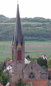
Jettenbach is a former farming village, and also one of the villages known for Musikantentum, an industry that formerly sent local musicians all over the world. The village also had regional craft businesses. In earlier times, the village displayed two layout types depending on whether one looked at the east end or the west, with the former laid out like a clump village and the latter like a linear village (or by some definitions, a “thorpe”). Looming over the village centre on a rise is the Evangelical village church, built in 1895-1896, which, owing to the great many Wandermusikanten (“travelling musicians”) at one time, is also widely known as the Musikantendom (“Musicians’ Cathedral”, although it is not a bishop’s seat). Next to that stands the Art Nouveau Leonhard Villa, known in Jettenbach as the Schlösschen (“Little Palace”). In 1989, the new village square with its Musikantenbrunnen – a fountain dedicated to the musicians of yore – was completed in the village centre. In the village’s south end, a leisure ground has been developing since 1978, made up of a swimming pool (which was already there in the 1930s), a grass sporting ground and two clay tennis courts. When a primary school was built in Jettenbach, the multipurpose hall built there, which was suitable for school sports, offered further leisure possibilities. Also planned is the expansion of a disused rural path to make it into an educational nature path where a dry stone wall, with different parts in different conditions will host various creatures for visitors to observe. The graveyard lies on the way out of the village going towards Bosenbach on the left side of the road. Jettenbach is today a bedroom and recreational community that only offers a few jobs. In 1714, an Erbbestandsbrief (Erbbestand is a uniquely German landhold arrangement in which ownership rights and usage rights are separated; this is forbidden by law in modern Germany) was first issued for a small mill north of the village. This mill was renovated before 1800 and expanded by a farming operation. It never had anything more than local importance, though, because there was only ever enough water to drive it in the winter months. The mill was given up about 1930 and torn down in 1958-1959.[4]
History
Antiquity
Evidence of human presence can be found within Jettenbach’s limits dating from almost every era back to the Stone Age. Particularly worthy of mention is a settlement centre from the Middle Stone Age, which over several years was surveyed and analyzed. Stone Age people camped over several centuries on the ridge east of the “Witthau” forest, where the one archaeological find bearing witness to their presence was unearthed, a small-bladed knife from the late Old Stone Age. At the same site, which was visited several times in the early 1990s, artefacts mainly from the Middle Stone Age were brought to light. There were only sporadic finds from the New Stone Age.
From the Bronze Age and the Iron Age come the remnants of barrows in the Jungenwald (woods) between Jettenbach and Kollweiler. Unfortunately, little of these mounds’ contents has been preserved.
Among what is left, however, are an axe and a sacrifice knife. Discovered on the Wingertsberg (mountain) was a grave field that comes from early Roman times. On the peak of the Potschberg, which has now been stripped away by stone quarrying, the remnants of a mountain sanctuary from the 2nd or 3rd century AD (Roman times) were found in 1965. Three homesteads from Roman times are known to have lain within what are now Jettenbach’s limits, while others are suspected. Unearthed here as a result of land surveys have been, among other things, quite a few coins from the first to fourth centuries AD, water pipes and a 5 cm-tall 2nd-century bronze figure of the god Mercury. Two settlement complexes were examined more closely. By 1960, a settlement was found on the municipality’s western limit with Bosenbach, and an archaeological dig was undertaken. Unearthed here were wall remnants, waste, clay waterpipes and pieces of little heating pipes, leading investigators to conclude that it was a settlement from the 2nd and 3rd centuries. A thorougher investigation was done at the settlement complex on the Trautmannsberg (or Trautelsberg, but in either case, a mountain). Here, in 2002-2003, the laying of a long-distance gas pipeline made possible an intensive investigation of the land. This site was an exceedingly large Roman complex. There might have been both a temple zone and a villa rustica here, bearing witness to which are the many outbuildings. An adjoining area of about one hectare was placed under protection.
Also unearthed along the pipeline’s route was some building work from Celtic forerunner buildings was also dug up, remnants of posts from pit-houses. In 1995, and urn graveyard from the early Roman epoch was shown to have existed on the Wingertsberg (mountain).[5]
After the Romans withdrew from the region, the area that is now Jettenbach remained uninhabited for several centuries. It was only in the time when the Franks took over the land that people once again settled there.
Middle Ages
Nothing is known about Jettenbach’s founding. It is believed that this dates back before the year 1000, but Jettenbach did not have its first documentary mention until 1348 (a full transcription of the document in question, in archaic German, can be found in the German article). At that time, Jettenbach belonged to the extensive area of the Reichsland (“Imperial Land”) near Kaiserslautern, which was already subdivided into separate court districts (Gerichte). Jettenbach belonged to the Gericht (or Amt) of Deinsberg (Theißberg). Later, this Amt was described as the Schultheißerei of Reichenbach, and for a time also as the Jettenbacher Gericht. This may well have something to do with where the Schultheiß’s seat was at any given time.
Another document from 1393 shows that the village was once made up of two centres, Obergittenbach and Niedergittenbach. It is certain that the latter is today’s village. Where the former lay, though, is likewise not known with any certainty. If oral tradition can be believed, it lay at the forks of the Rutzenbach and the Selchenbach, the municipality’s two brooks.
The Gericht of Deinsberg belonged beginning in the earlier half of the 14th century to the Counts of Veldenz. At the time the two brothers, Count Heinrich III and Count Friedrich II, divided their holdings, the village passed to the former, and as an Amt seat with its villages. In the letters bestowing these holdings upon Count Friedrich III, however, Jettenbach was part of the combined Amt of Reichenbach and Deinsberg, and was split into Ober-Gittenbach and Nieder-Gittenbach. After the Counts of Veldenz died out in 1444, the village, along with the rest of the Amt of Reichenbach, passed to the Dukes of Palatinate-Zweibrücken.[6]
Modern times
In 1543, Jettenbach passed to the newly formed Principality of Palatinate-Veldenz, whose residence town was Lauterecken (and hence, the principality was also known as Veldenz-Lauterecken). Clearer details about the village’s history only emerge beginning in this time.
The Thirty Years' War brought downfall for Jettenbach, as it did for so many villages. Given the village’s location some way off the military roads, it was possible, at least for a while, for the people to stay in their houses. Nevertheless, it must be assumed that the village was largely destroyed and that three fourths of the population fell victim to the war or to the waves of sickness that it brought. Refuge was often sought within the walls of Lauterecken, the princely family’s residence town.
After the war, new settlers came to the village, as witnessed by names in documents. These new villagers mixed with the older ones and soon had to bear with them through more war. French King Louis XIV’s wars of conquest brought the villagers such hardship and woe that at times things were as bad as they had been in the Thirty Years' War. The princely House of Veldenz was powerless to do anything about the onslaught. Their last male member died in 1694 in Strasbourg, and there then arose a dispute between the Duchy of Palatinate-Zweibrücken and Electorate of the Palatinate as to who the rightful heir to the now defunct House’s domains was. Electorate of the Palatinate troops quickly occupied the Amt of Lauterecken and the Schultheißerei of Reichenbach after the French had withdrawn in 1697. The dispute was not resolved until 1733.
Only in the early 18th century had Jettenbach once again reached its former size, but it was at this time that villagers began to turn their back on the village. As early as 1708-1709, one family from Jettenbach left the village for America to make a new beginning. In the late 18th century, quite a few families and persons tried to earn a better living in the realm of the Danube Monarchy and in Russia.
In 1733, by compromise between the two princely houses, Jettenbach was to be held permanently by the Electorate of the Palatinate, although it was not at all permanent: By about 1800, French Revolutionary intervention had swept the historical lordships away, and this time and the Napoleonic era that followed saw the region under French rule once again.[7]
Recent times
During the years of the French Revolution, the Mairie (“Mayoralty”) of Jettenbach comprised the villages of Albersbach, Eulenbis, Jettenbach, Kollweiler and Pörrbach. The mayoralty was in the time of French rule part of the Canton of Wolfstein, the Arrondissement of Kaiserslautern and the Department of Mont-Tonnerre (or Donnersberg in German).
The emigration that had begun in the early 18th century stopped for a while when the village was under French Revolutionary and then Napoleonic French rule. Jettenbach had to put up with troops on the march, yielding up supplies, troops stationed in the village and, on one occasion – on 4 January 1794 – troops plundering the village. They took everything. Besides food and livestock, they took the villagers’ household belongings and even their clothes.
During Napoleon’s campaigns, men from Jettenbach were duty-bound to fight under the French flag for Napoleon’s empire, and did so throughout Europe. The empire’s downfall once again brought Jettenbach burdens, such as German troops stationed in the village and withdrawing Russian troops. The new order worked out by the Congress of Vienna, which went into force in 1816, annexed the Palatinate to the Kingdom of Bavaria, whereafter Jettenbach belonged to the Canton of Wolfstein and the Landkommissariat of Kusel. Only Kollweiler (until about 1890) and Albersbach (until 1969) remained in the Bürgermeisterei (“Mayoralty”) of Jettenbach. The membership in the Canton of Wolfstein remained in force into the 20th century.
In the early 19th century, there was a notable upswing in Jettenbach’s population. This led, through the customary division of land bequests, to the economic downfall of many farming families in Jettenbach, which forced people to seek other means of earning a livelihood. A heavily populated handicraft industry could only sell so much of its wares, and this led once again to waves of emigration in the 19th century. Almost without exception, the emigrants went to the United States. The last wave of emigration came in the time between the world wars and involved about 200 people.
Economic problems in the Palatinate arising from the region’s discontiguity with the rest of the Kingdom of Bavaria led to efforts to split the Palatinate away from Bavaria. This movement reached its high point with the 1849 Palatine Uprising. There was activity in Jettenbach, too. The candidate teacher Ludwig Heinrich Hauber, who was born in Jettenbach, advocated his ideals. He went as far as to secure leave from his teaching post in Katzweiler to dedicate himself wholly to his goal. Ludwig Heinrich Hauber was primarily engaged in the canton of Wolfstein with making monetary instruments and raising the Landsturm (people’s army).
In Jettenbach itself, a heavily attended people’s assembly took place on 10 June 1849 in the “Strieth” woods. The next day, Hauber mobilized the Landsturm, which was to fight off the advancing Prussians. There were few guns at these men’s disposal. Indeed, most had primitive weapons such as scythes, pitchforks and flails, and with these they hoped to beat the Prussian army. The men, however, had agreed that if there were to be any danger, they would betake themselves to their homes, and indeed this is what they promptly did as the Prussians drew nearer. Even Hauber, now deserted by his troops, thought it best to flee, without ever having seen even one Prussian. Thus ended the “Palatine Revolution” for Jettenbach in very short order, before it had even begun.
As late as the last third of the 19th century, there had been very little change in Jettenbach’s economic circumstances. Only after the Franco-Prussian War in 1870-1871 could some economic improvement be felt. This upswing came partly because of the Wandermusikanten, whole orchestras of travelling musicians who earned their living playing music in many parts of Europe, and indeed the world. Their buying power and the brisk building activity that was beginning at this time were mainly responsible for the better economic situation. Whole rows of buildings went up and the village began to see lively growth. At the beginning of the 20th century, there were more than 1,000 inhabitants in Jettenbach.
These “good old days” were brought to an end by the outbreak of the First World War. Many men from Jettenbach were called into the military to fight for the Kaiser. Many of them never came home. After the war, times were hard, for there were few job opportunities.
As early as 1926 or 1927, some, mostly young men, came into contact with National Socialism. About 1929, there was already a local Nazi cell in Jettenbach, which had joined itself to the local group (Ortsgruppe) in Kollweiler that had been founded in 1928. In 1933 – the same year that Adolf Hitler seized power – the Nazis also managed to win every seat on municipal council. For jobless inhabitants at least, this meant a gradual improvement of their lot. To make work, the Nazis had the Jettenbach – the village’s namesake brook – straightened and lined with bricks, and also had a “bathing pond” built. Bit by bit, the orders grew for the quarry belonging to neighbouring Eßweiler, and it eventually employed more than 600 workers.
With the outbreak of the Second World War, most men fit for service had to go to war. The shortfall in the agricultural labour force was bolstered by prisoners of war from France and forced labour from the Eastern Territories. During the war, Jettenbach was not directly confronted with martial action, but towards the end of the war, as German troops were withdrawing ahead of the Allied advance, they were often billeted temporarily in Jettenbach. The last German troops left Jettenbach about midday on 17 March 1945. Outside the village, though, they quickly found themselves under attack by American airmen. Just over two days later, the first United States Army troops arrived in the village.
Of all the changes that Jettenbach has undergone, none has been quite as thorough as the one that came in the wake of the Second World War. Whereas the village had hitherto been characterized by farmers, craftsmen, musicians and working people, most of the population were now finding the underpinnings of their old livelihoods changing very swiftly, in only a few years. Already before the Second World War, the region’s well known Musikantentum, the industry that involved musicians earning a living all round the world, had come to an end. Some old Musikanten dreamt of reviving past glories, but they soon had to acknowledge that those days were forever bygone.
A shift in Jettenbach’s economic foundations could be seen by the early 1950s when more and more people began to take jobs outside the village. Some of these new jobs were with the United States Armed Forces in Kaiserslautern, Ramstein and Miesau.
An upswing in the building industry created further jobs. In Jettenbach itself, the agricultural sector was steadily shrinking. This also brought down the craft sector, many of whose businesses depended heavily on the agricultural sector. Today, the visitor sees a village that is almost wholly residential in function. Farming can now only be seen at one of the so-called Aussiedlerhöfe (farming hamlets established in modern times), two of which have already been forsaken.
In 1972, Jettenbach was grouped into the newly formed Verbandsgemeinde of Wolfstein.[8]
There are also few craft businesses left. There is, however, still a butchering business with its own slaughtering and a grocer’s shop with baked goods, which at least make basic foodstuffs locally available.
The most successful business in Jettenbach is still the stone quarry run by Basalt AG. Here, the stone is processed and then either stored in silos for sale or stockpiled in a storage area for onward transport. The yearly yield can be up to 600,000 metric tons. The quarry business is joined to a bitumen mixing complex.
Jettenbach’s best showing to date in the contest Unser Dorf soll schöner werden (“Our village should become lovelier”) was in 2003, when it won second place in the main class at the district level, which qualified it for the Rhenish Hesse-Palatinate regional contest, in which it placed first. This was the first time that Jettenbach qualified for the state level, in which it placed seventh.
In November 2003, the Minister for Environment and Forests, Margit Conrad, awarded Mayor Bernd Ginkel the special prize for “the municipality’s model ecological performance”. This was based mainly on the forward-looking heating plants (wood pellets and woodchips), the solar and photovoltaic complexes and a distinct engagement for nature conservation within the municipal area.[9][10][11]
Population development
As early as 1709, there was a mention of a first emigrant to America from Jettenbach. In the late 18th century there was emigration to southeastern Europe, and after 1800 also to Poland and Bavaria. In the 19th and 20th centuries, there were phases of heavy emigration to the United States. In the 19th century, the Wandermusikantentum industry, in which local inhabitants travelled all over Europe and even the world as musicians, began. It had its roots in the region’s poor economic conditions. Despite the emigrations, a continuous rise in population figures was recorded, although more recently, this has levelled off. The Wandermusikanten fostered their own family and speech peculiarities, their own customs and their own costume. Their speech was enriched with words drawn from the various languages with which they came into contact while they were abroad. In 1721, Jettenbach had 35 families and therefore roughly 140 inhabitants. In 1815 there were 657 inhabitants, and in 1905, 1,031.[12]
Municipality’s name
The first syllable of the municipality’s name, Jettenbach, refers to perennial ryegrass (Lolium perenne), which still grows along the village brook today. It comes from the Old High German root jetto, which was used either as a word for “weed” or as the name for the plant perennial ryegrass (in Modern High German, however, it is called Deutsches Weidelgras or Wiesenlolch). Whether in fact there was a person whose name was connected with this jetto is unknown. It is thus assumed that whoever the first settlers were, they had to weed (German: ausjäten – here the root does show up) the land of this ryegrass so that they could use it as farmland. To the word jetto, the element —bach (German for “brook”) was added, thus making the name’s original meaning something like “brook that flows through a dale overgrown with ryegrass”.[13] Alongside the name’s current form, the form Gettenbach also showed up in the past. Against this, one can compare the dialectal form gäten to the Middle High German jäten, with the J/G variants also in evidence. Among other forms of the name that are known from the past are Jettenbach (1348), Gyttenbach (1377), Obergittenbach and Niedergittenbach (1393), Gettenbach (1571), Göttenbach (1600) and Jettenbach once again.[14]
Vanished villages
Lying in the northern part of the current municipal area was once another village, Zeißweiler, which may have been older than Jettenbach itself. It was geographically the last place in the string of settlements with names ending in —weiler (German for “hamlet”, or originally “homestead”) at the end of the Eßweiler Tal (valley or dale). A single legal document from 1432 is all the proof that there is that this village even existed, and even at the time that that was written, the settlement had already been forsaken. Nothing is known of the village’s fate, nor of its people’s. While it is known that Zeißweiler lay north of Jettenbach at the foot of the Trautelsberg – at least according to researcher Ernst Christmann – its exact location is also unknown.[15]
Religion
About 1600, all the village’s inhabitants were Lutheran. Even after the Thirty Years' War, it was mostly Protestants living in Jettenbach. As late as 1825 it was still almost 100%. Then, though, the number of Catholics began to grow slowly. In 1991, there were 63 Catholics in the village.
Even in the earliest days, Jettenbach belonged to the parish of Reichenbach. Even after the Lutheran parish of Reichenbach was founded in 1532, it remained in this. Only towards the end of 1741 was Jettenbach raised to a Lutheran parish in its own right. Also joining this was the neighbouring village of Kollweiler as an affiliated village. Both villages already had their own churches in the Late Middle Ages at which the pastor from Reichenbach held services. Jettenbach’s Reformed (Calvinist) inhabitants were attached beginning in 1746 to the then newly formed Reformed parish of Neunkirchen. In 1971, the two villages of Bosenbach and Niederstaufenbach were grouped into the Protestant parish of Jettenbach as affiliates after the parish of Bosenbach was dissolved.
The old mediaeval chapel had two patron saints, Saint Valentine and Saint Anastasius. This chapel was destroyed about 1470 but built once again in the years that followed. It can be assumed that until the church that still stands today was built, this chapel was continually repaired and renovated. Today’s church was built in 1895-1896 in Gothic Revival style. It bears the byname Musikantendom (Dom means “cathedral” in German). This sobriquet owes itself to the extraordinarily great number of Wandermusikanten (travelling musicians) who once lived in Jettenbach, but also to the church’s size, for the church administration demanded that there be room for at least half the population at the time when the church was built; there is room in the pews for 532 worshippers. The church has a pneumatic conical-windchest organ, which was built in in 1896, with 1,149 pipes. It was built by the firm Walcker of Ludwigsburg.
Until 1871, the churchyard was the local graveyard. When it ran out of room for new graves, a new graveyard was laid out towards Bosenbach. In 1966, a graveyard hall was built with a bell. This was expanded in 2000-2001.
The village’s Catholics belonged from 1700 to the parish of Reichenbach. They had the right to carry out their major ceremonies, such as baptisms, weddings and funerals, at the old village church. Actual services, however, they were only allowed to hold on Laetare Sunday (the third Sunday before Easter). After the new church was built, the predominantly Protestant population refused to share it with the Catholics. In 1899, the Protestant then sold their traditional rights.[16]
Politics
Municipal council
The council is made up of 12 council members, who were elected by majority vote at the municipal election held on 7 June 2009, and the honorary mayor as chairman.[17]
Mayor
Jettenbach’s mayor is Bernd Ginkel, and his deputies are Günter Kleemann and Timo Harth.[18][19]
Coat of arms
The German blazon reads: In Grün ein silberner Schräglinkswellenbalken, oben rechts eine goldene Lyra, unten links ein goldenes Ährenbüschel (Wiesenlolch).
The municipality’s arms might in English heraldic language be described thus: Vert a bend sinister wavy between a lyre Or and issuant from base a ryegrass tussock bendwise sinister of the same.
The arms were designed in 1967 in collaboration with the then schoolteacher Straßenberg and the Speyer State Archive.
The bend sinister wavy (diagonal wavy stripe) and the ryegrass tussock are both canting charges for the municipality’s name (see above under Name). The lyre represents Jettenbach’s musical history as one of the centres in the Musikantenland.
The arms have been borne since 21 April 1967 when they were approved by the Ministry of the Interior in Mainz.[13][20]
Culture and sightseeing
Buildings
The following are listed buildings or sites in Rhineland-Palatinate’s Directory of Cultural Monuments:[21]
- Protestant parish church, Kirchstraße 2 – two-naved Gothic Revival hall church, 1895/1896, architect Franz Schöberl, Speyer; furnishings
- At Hauptstraße 31 – sandstone portal, marked 1829
- Near Hauptstraße 46 – hourstone, sandstone column, 19th century
- Hauptstraße 66 – Musikantenhaus (“minstrel’s house”); one-floor plastered building on pedestal floor, 1903/1904, architect Karl Faul, Reichenbach
- Höhstraße 2 – primary school, sandstone-framed plastered building, 1892/1893; Luitpold limetree from 1893
- Honiggasse 1 – Quereinhaus (a combination residential and commercial house divided for these two purposes down the middle, perpendicularly to the street), partly timber-frame, marked 1740 and 1776, one-floor addition with half-hipped roof, workshop building about 1900; stone oven pedestal, marked 1793, oven slab, marked 1720
- At Kirchstraße 5 – stone oven pedestal, marked 1801
- At Kirchstraße 8 – stone oven pedestal, marked 1829
The Quereinhaus at Honiggasse (“Honey Lane”) 1 is described elsewhere as a West Palatine farmhouse with a single roof ridge (Einfirstbauernhaus). It is the residential wing that dates from 1740 and the commercial wing that dates from 1776. The residential wing’s upper floor is built with exposed timber framing, a decorated groundsill, several chest- and neck-high railings and an oriel window.
The Musikantenhaus at Hauptstraße (“Main Street”) 66 is typical in construction for a house belonging to the travelling musicians of yore, especially for the inclusion of a dormer-like gable at the front.[22]
Regular events
The kermis in Jettenbach (church consecration festival, locally known as the Kerwe) is nowadays held on the third Sunday in August. In earlier times, a market was held on the Monday after Laetare Sunday and a fair was held at Whitsun. The timing used for the kermis today was set in 1890. Already towards the end of the 19th century, Fasching (Shrovetide Carnival) was being celebrated in Jettenbach. At that time, masked parades, show booths and gatherings at the inns were customary. After the First World War, there were only Kappensitzungen (“Hat Sessions”) and, as before, the inns. Only in the 1950s were great Prunksitzungen (Sessions of the “parliament” of the “Empire of Narren”, that is, fools) and masquerade balls, although the latter are hardly customary anymore. Each year on the Third Day of Christmas (27 December), there is a procession with a person bound up in straw. This seemingly odd custom may have either of two origins. On the one hand, it is still the way in which Wanderstag, the day on which servants changed jobs, is celebrated, and on the other hand, it might be a matter of a Carnival custom having been moved to this day.[23]
Clubs
The following clubs are to be found in Jettenbach:[24]
- Arbeiter-Musikverein (merger 1951) — workers’ music club
- Arbeiterverein (1922) — workers’ club
- Gesangverein Harmonie (1860) — singing club
- Krankenpflegeverein (1975) — nursing club
- Landfrauenverein (1969) — countrywomen’s club
- Musikverein (1882) — music club
- Pfälzerwaldverein (1974) — hiking club
- Pfälzische Bauern- und Winzerschaft (~1950) — farmers’ and winegrowers’ club
- Rote Flut (1991) — 1. FC Kaiserslautern fan club
- Seniorenverein (1981) — seniors’ club
- SPD-Ortsverein (1946-1948; since 1964) — Social Democratic Party of Germany local chapter
- Tennisverein (1978) — tennis club
- Turn- und Sportverein (1892) — gymnastic and sport club
The singing club „Harmonie“ 1860 Jettenbach e.V. celebrated its 150-year jubilee in 2010 and is among the Kusel district’s oldest clubs (inexplicably, another source identifies this club as a forerunner of the music club, and identifies its founding year as 1885). The club with the most members in Jettenbach is the Turn- und Sportverein Jettenbach (sport club).
Some clubs have passed into history:[24]
- Ackerbauverein (1927-1957) — cropraising club
- Gewerbeverein (~1900-1933) — commerce club
- Kriegerverein (1874-1933) — warriors’ club
- Viehversicherungsverein (1868-~1945) — livestock insurance club
- Volksbildungsverein (~1900-~1925) — people’s training club
Economy and infrastructure
Economic structure
Nineteenth-century agriculture in Jettenbach was characterized by many small farms. The farmers with bigger farms had horses, and sometimes oxen as draught animals. On smaller farms, the cow was used as a draught animal. From this need arose the almost exclusive use of the Glan-Donnersberg breed of cattle. It dominated in Jettenbach even into the 1960s. Most farms did cropraising and livestock husbandry. Pig farming was rather rare, and sheep were only raised until about the turn of the 19th century. Specialized crops are no longer raised in Jettenbach, although the village is said to have been a main growing centre for rapeseed in the Landcommissariat of Kusel in the years after 1820 (4 226 hl in 1826). About 1870, herb growing, particularly for the seed, was important in the village. Among the herbs then grown were hops, for the brewery that was then found in Jettenbach. Winegrowing may have been practised here in the Middle Ages, bearing witness to which are certain local cadastral toponyms. Between 1870 and 1900 there was once again a vineyard (1 000 m²) in the village. There was also fruitgrowing in a meadow orchard.
After 1840, as in so many other villages in the district, a new industry arose, Wandermusikantentum, which saw local musicians travel the world over plying their trade. Men – it was most often men – went abroad in groups of 5 to 15 and earned their living by playing music. Mostly they had firm engagements at spa hotels or bathing beaches. Early on in Wandermusikantentum, the musicians sometimes also took jugglers along with them. They could sometimes also be hired as circus orchestras. In the United States, they travelled on pleasure steamers on the country’s great rivers. In the early days, the musicians went to neighbouring countries such as France, Belgium, the Netherlands and Switzerland. After the Franco-Prussian War (1870-1871), they no longer went to France, though, a country still seething at the loss of the war, and of a sizeable piece of territory, Alsace-Lorraine, to the newly minted German Empire. Instead, they focused their efforts on Eastern Europe. It was only in the 1880s that some of these local musicians became bold enough to visit the United States, but before the turn of the century, there were few parts of the world where the Wandermusikanten had not trodden. It was not unheard-of for them to seek work in South Africa, Australia or Southeast Asia. How long they were away from home depended to a great extent on how far away they went. One of their American tours, for instance, might last 20 months, while those who went to make music in Australia might not see home for five years. Jobs within Europe, however, allowed them to work only nine months of the year and return home for the winter. In 1908, there were 102 musicians living in Jettenbach. They only interrupted the plying of their craft when they were forced to – by the First World War. Many were away from Germany when this broke out, and found themselves in countries that had suddenly become hostile towards Germans. In the United Kingdom, Australia and the United States, many were interned. After the war, there was a great decline in this industry, and then, after Adolf Hitler and the Nazis started the Third Reich in the 1930s, the industry was forsaken, utterly.
Aside from a very small amount of mining towards the end of the 18th century (iron ore, quicksilver) and coal mining (about 1860), the only mining that can be mentioned is limestone and basalt quarrying. Limestone was already being quarried in the 16th century. In the 19th century, there were several lime kilns in Jettenbach. Limestone quarrying was, however, given up in 1903. At the turn of the 20th century, hard-stone quarries were being opened up. When railways were built through the Glan and Lauter valleys, transporting the stone to faraway markets became possible. Thus, several quarries opened in Jettenbach where paving stones were made. In the 1920s, some 60 quarrymen from Jettenbach worked at the nearby quarry on the Schneeweiderhof. Today, one of the Palatinate’s most productive quarries lies in the Jettenbach area, on the Potschberg.
Many Jettenbachers have since found jobs in Kaiserslautern, NATO’s Ramstein Air Base in Ramstein-Miesenbach or elsewhere in the narrower or broader area around Jettenbach. Thus, most inhabitants nowadays are commuters. The village’s first watermain was built in 1909, but nowadays, Jettenbach is hooked up to the West Palatinate joint water authority. The first electrical hookup came in October 1922. There has only been a gas main available, however, since November 1991.[25]
Education
Even before 1700, a school had been set up in Jettenbach, which was overseen by the Lutheran pastor. Mentioned towards the end of the 18th century, besides the schoolteacher hired by the Lutherans, was a Reformed (Calvinist) schoolmaster who oversaw the winter school (a school geared towards an agricultural community’s practical needs, held in the winter, when farm families had a bit more time to spare). In 1819, a new schoolhouse with two classrooms was built, whereupon a teaching assistant was hired and placed at the schoolteacher’s disposal to help him with the second class. In 1882, a third class was formed once another schoolhouse had been built. In 1891, the municipality then built yet another schoolhouse with two classrooms, and the old schoolhouse was given up. These three classrooms were in service until 1965, when grade levels 7 and 8 were transferred to the Mittelpunktschule (“midpoint school”, a central school, designed to eliminate smaller outlying schools) in Wolfstein. In 1971, the Jettenbach and Rothselberg schools for grade levels 1 to 4 were combined, with Eßweiler, Hinzweiler and Oberweiler im Tal joining in 1988. The five villages now together formed the Königslandgrundschule (“King’s Land Primary School” – from an historical name for the region), which currently still serves three of the villages. A one-and-a-half-floor primary school building for these three villages was built in 2001-2002 in Jettenbach. Also built by the municipality at the school was a multipurpose hall that could serve the school’s sport needs. From the beginning of the 20th century until the late 1920s, there was also a vocational school in Jettenbach.[26]
Kindergarten
In 1973, the Kusel district’s first central kindergarten was built in Jettenbach, to be attended by children from Eßweiler, Jettenbach, Hinzweiler, Oberweiler im Tal and Rothselberg. After the special-purposes committee had been dissolved, a new, local kindergarten was built in Jettenbach. This was brought into service in the spring of 2004. The other municipalities had already built their own kindergartens in Hinzweiler and Rothselberg.[27]
Transport
To the east runs Bundesstraße 270. Running through the village itself are Landesstraßen 370 and 369. Serving Kreimbach-Kaulbach is a railway station on the Lautertalbahn.[28]
Famous people
Sons and daughters of the town
- Dr. Carl Andreae (b. 1841; d. 1913 in Munich) — Educator, seminary inspector at the teacher-training institute in Kaiserslautern, member of the state school inspectorate in Bavaria, 1893-1907 Liberal Party member of the Bavarian Landtag, Privatdozent at the University of Munich.
- Ludwig Heinrich Hauber (b. 1827; d. 1902 in Arch, Austria-Hungary [now Arco, Italy]) — School assistant, 1849 revolutionary, civil engineer. After participating in the Revolution, he was barred from returning to teaching. After working various jobs in industry and crafts, he had the luck to marry into wealth. Along with his wife he endowed several foundations in the Palatinate.
- Karl Kiefer (b. 1871; d. 1957 in Munich) — Sculptor and professor in Munich
- Hubertus “Bertes” Kilian (b. 1827; d. 1899 in Munich) — “Minstrel” (travelling musician), Imperial Chinese Orchestra Master, one of the best known and most widely travelled of the Wandermusikanten.
- Jakob Leonhard (b. 1859; d. 1931 in Heidelberg) — Secret commercial councillor, Director of the Kaiserslautern worsted-spinning mill, founding member of the Verband Pfälzischer Industrieller (“Association of Palatine Industrialists”).[29]
Famous people associated with the municipality
- Franz Leonhard (b. 1852; d. 1905 in Neckargemünd) — Chemist. He was on staff at the Rottweil powder factory, where he was involved in research and development, earning several patents for, among other things, the development of a smokeless powder.
- Johann Heinrich August Schowalter (b. 1870 in Neustadt; d. 1940 in Berlin) — Pastor (Jettenbach 1903-1910), he dedicated himself to bettering the population’s economic state and providing people’s needs in the local area. He was, among other things, an ardent campaigner for a school for training professional musicians in Jettenbach.[30]
References
- ↑ "Bevölkerung der Gemeinden am 31.12.2012". Statistisches Bundesamt (in German). 2013.
- ↑ Location
- ↑ Constituent communities
- ↑ Municipality’s layout
- ↑ Antiquity
- ↑ Middle Ages
- ↑ Modern times
- ↑ Recent times
- ↑ Jettenbach’s first documentary mention
- ↑ Jettenbach’s history
- ↑ Jettenbach’s history (continued)
- ↑ Population development
- ↑ 13.0 13.1 Quelle: Jettenbach 1348 - 1998 Ortschronik
- ↑ Municipality’s name
- ↑ Vanished villages
- ↑ Religion
- ↑ Kommunalwahl Rheinland-Pfalz 2009, Gemeinderat
- ↑ Jettenbach’s mayor
- ↑ Jettenbach’s executive
- ↑ Description and explanation of Jettenbach’s arms
- ↑ Directory of Cultural Monuments in Kusel district
- ↑ Buildings
- ↑ Regular events
- ↑ 24.0 24.1 Clubs
- ↑ Economic structure
- ↑ Education
- ↑ Kindergarten
- ↑ Transport
- ↑ Sons and daughters of the town
- ↑ Famous people associated with the municipality
External links
| Wikimedia Commons has media related to Jettenbach (Pfalz). |
- Municipality’s official webpage (German)