Jericho
| Jericho | ||
|---|---|---|
| Other transcription(s) | ||
| • Arabic | أريحا | |
| • Hebrew | יריחו | |
|
The city of Jericho | ||
| ||
 Jericho Location of Jericho within Palestine | ||
| Coordinates: 31°51′N 35°27′E / 31.850°N 35.450°ECoordinates: 31°51′N 35°27′E / 31.850°N 35.450°E | ||
| Governorate | Jericho | |
| Founded | 9600 BC | |
| Government | ||
| • Type | City (from 1994) | |
| • Head of Municipality | Hassan Saleh[1] | |
| Area | ||
| • Jurisdiction | 58,701 dunams (58.701 km2 or 22.665 sq mi) | |
| Population (2006) | ||
| • Jurisdiction | 20,300 | |
| Name meaning | "Fragrant" | |
| Website | www.jericho-city.org | |

Jericho (/ˈdʒɛrɪkoʊ/; Arabic: أريحا ʾArīḥā [ʔaˈriːħaː]; Hebrew: יריחו Yeriẖo) is a city located near the Jordan River in the West Bank. It is the administrative seat of the Jericho Governorate. In 2007, it had a population of 18,346.[2] The city was occupied by Jordan from 1949 to 1967, and has been held under Israeli occupation since 1967; administrative control was handed over to the Palestinian Authority in 1994.[3][4] It is believed to be one of the oldest inhabited cities in the world.[5][6][7]
Archaeologists have unearthed the remains of more than 20 successive settlements in Jericho, the first of which dates back 11,000 years (9000 BC),[8][9] almost to the very beginning of the Holocene epoch of the Earth's history.[10][11]
Jericho is described in the Hebrew Bible as the "City of Palm Trees". Copious springs in and around the city attracted human habitation for thousands of years.[12]
Etymology
Jericho's name in Hebrew, Yeriẖo, is thought to derive from Canaanite word Reaẖ ("fragrant"), though an alternative theory holds that it is derived from the word meaning "moon" (Yareaẖ) in Canaanite, or the name of the lunar deity Yarikh, for whom since the city was an early centre of worship.[13]
Jericho's Arabic name, ʼArīḥā, means "fragrant" and derives from same Canaanite word Reaẖ, of the same meaning as in Hebrew.[14][15][16][17]
History
The city may be the oldest continuously occupied city in the world.[18]
Ancient period
Natufian Hunter-Gatherers c. 10,000 BC
Jericho has evidence of settlement dating back to 10,000 BC. During the Younger Dryas period of cold and drought, permanent habitation of any one location was not possible. However, the spring at what would become Jericho was a popular camping ground for Natufian hunter-gatherer groups, who left a scattering of crescent microlith tools behind them.[19] Around 9600 BC the droughts and cold of the Younger Dryas Stadial had come to an end, making it possible for Natufian groups to extend the duration of their stay, eventually leading to year round habitation and permanent settlement.
Pre-Pottery Neolithic Age, c. 9600 BC


The first permanent settlement on the site of Jericho developed near the Ein as-Sultan spring between 10,000 and 9000 BC.[20][21] As the world warmed, a new culture based on agriculture and sedentary dwelling emerged, which archaeologists have termed "Pre-Pottery Neolithic A" (abbreviated as PPNA). PPNA villages are characterized by small circular dwellings, burials of the dead within the floors of buildings, reliance on hunting wild game, the cultivation of wild or domestic cereals, and no use of pottery. At Jericho, circular dwellings were built of clay and straw bricks left to dry in the sun, which were plastered together with a mud mortar. Each house measured about 5 metres (16 ft) across, and was roofed with mud-smeared brush. Hearths were located within and outside the homes.[22]
By about 9400 BC the town had grown to more than 70 modest dwellings. Estimates put the population as high as two to three thousand people and as low as two to three hundred.[23] Most strikingly, this early town featured a massive stone wall over 3.6 metres (12 ft) high and 1.8 metres (5 ft 11 in) wide at the base. Inside this wall stood a tower over 3.6 metres (12 ft) high, containing an internal staircase with 22 stone steps.[15][24] The wall and tower have no known precedent in human culture, and would have taken a hundred men more than a hundred days to construct. The wall may have served as a defence against flood-water, with the tower used for ceremonial purposes.[23]
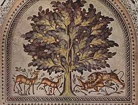
After a few centuries the first settlement was abandoned. A second settlement, established in 6800 BC, perhaps represents the work of an invading people who absorbed the original inhabitants into their dominant culture. Artifacts dating from this period include ten plastered human skulls, painted so as to reconstitute the individuals' features.[15] These represent the first example of portraiture in art history, and it is thought that they were kept in people's homes while the bodies were buried.[7][25]
A succession of settlements followed from 4500 BC onward, the largest constructed in 2600 BC.[15]
Bronze Age
Archaeological evidence indicates that in the later half of the Middle Bronze Age (MBE, c. 1700 BC) the city enjoyed some prosperity, its walls having been strengthened and expanded.[26] The MBE period and following centuries have engendered controversy due to their importance in the Biblical story of conquest of the "promised land" by the Israelites, during which the walls of the city are supposed to have collapsed, allowing the Israelites led by Joshua to enter the town. John Garstang, who excavated in the 1930s, announced that he had found fallen walls dating to the time of the biblical Battle of Jericho.[27] However, Garstang later revised the destruction to a much earlier period.[27] Kathleen Kenyon dated the destruction of the walled city to the middle of the 16th century (c. 1550 BC), too early to match the Biblical story (assuming the traditional date), on the basis of her excavations in the early 1950s.[28] The same conclusion, based on an analysis of all the excavation findings, was reached by Piotr Bienkowski.[29] Kenyon's dating was challenged by Bryant Wood in 1990, largely on the argument that Kenyon had misinterpreted the ceramic evidence.[30] William Dever accused Wood of deceiving the public, while Bienkowski accused Wood of multiple errors, which Wood strenuously denied.[31][32][33] In 1995, Bruins and var der Plicht announced radiocarbon dating of the city destruction to between 1617 and 1530 BC, agreeing with Kenyon.[34]
After the destruction of the city, occupation was minor until about the 11th century.[27]
Iron Age
In the 8th century BC the Assyrians invaded from the north, followed by the Babylonians, and Jericho was depopulated between 586 and 538 BC, the period of the Jewish exile to Babylon. Cyrus the Great, the Persian king, refounded the city one mile (1.6 km) southeast of its historic site at the mound of Tell es-Sultan and returned the Jewish exiles after conquering Babylon in 539 BC.[15]
Classical antiquity


Jericho went from being an administrative centre of Yehud Medinata ("the Province of Judah") under Persian rule to serving as the private estate of Alexander the Great between 336 and 323 BC after his conquest of the region. In the middle of the 2nd century BC Jericho was under Hellenistic rule of the Seleucid Empire, when the Syrian General Bacchides built a number of forts to strengthen the defences of the area around Jericho against the revolt by the Macabees.[35] One of these forts, built at the entrance to Wadi Qelt, was later refortified by Herod the Great, who named it Kypros after his mother.[36]
The city came to be ruled by the Hasmoneans, a dynasty descending from a priestly group (kohanim) from the Tribe of Levi, following the success of the Maccabean Revolt, and remained such until the Roman influence over the area brought Herod to claim the Hasmonean throne of Judea.
Herod originally leased Jericho from Cleopatra, after Mark Antony gave it to her as a gift. After their joint suicide in 30 BC, Octavian assumed control of the Roman Empire and granted Herod absolute rule over Jericho, as part of the new Herodian domain. Herod’s rule oversaw the construction of a hippodrome-theatre (Tel es-Samrat) to entertain his guests and new aqueducts to irrigate the area below the cliffs and reach his winter palace built at the site of Tulul al-Alaiq.[36]
The dramatic murder of Aristobulus III in a swimming pool in Jericho, as told by the Roman Jewish historian Josephus, took place during a banquet organized by Herod's Hasmonean mother-in-law. After the construction of its palaces the city had functioned not only as an agricultural center and as a crossroad but as a winter resort for Jerusalem's aristocracy.[37]
Herod was succeeded in Judea by his son, Archelus, who built an adjacent village in his name, Archelais, to house workers for his date plantation (Khirbet al-Beiyudat). First-century Jericho is described in Strabo's Geography as follows:
Jericho is a plain surrounded by a kind of mountainous country, which in a way, slopes toward it like a theatre. Here is the Phoenicon, which is mixed also with all kinds of cultivated and fruitful trees, though it consists mostly of palm trees. It is 100 stadia in length and is everywhere watered with streams. Here also are the Palace and the Balsam Park."[36]
The rock-cut tombs of a Herodian and Hasmonean era cemetery lie in the lowest part of the cliffs between Nuseib al-Aweishireh and Jebel Quruntul in Jericho and were used between 100 BC and 68 AD.[36]

The Christian Gospels state that Jesus of Nazareth passed through Jericho where he healed one[38][39] or two[40] blind beggars and inspired a local chief tax-collector named Zacchaeus to repent of his dishonest practices. The road between Jerusalem and Jericho is the setting for the Parable of the Good Samaritan.[41] John Wesley, in his New Testament Notes on this section of Luke's Gospel, claimed that "about twelve thousand priests and Levites dwelt there, who all attended the service of the temple".[42]
After the fall of Jerusalem to Vespasian's armies in the Great Revolt of Judea in 70 AD, Jericho declined rapidly, and by 100 AD it was but a small Roman garrison town.[43] A fort was built there in 130 and played a role in putting down the Bar Kochba revolt in 133. Accounts of Jericho by a Christian pilgrim are given in 333. Shortly thereafter the built-up area of the town was abandoned and a Byzantine Jericho, Ericha, was built a mile (1.61 km) to the east, around which the modern town is centred.[43] Christianity took hold in the city during the Byzantine era and the area was heavily populated. A number of monasteries and churches were built, including St George of Koziba in 340 AD and a domed church dedicated to Saint Eliseus.[37] At least two synagogues were also built in the 6th century AD.[36] The monasteries were abandoned after the Persian invasion of 614.[15]
Arab Caliphate era
Jericho, by then named "Ariha" in Arabic variation, became part Jund Filastin ("Military District of Palestine"), part of the larger province of Bilad al-Sham. The Arab Muslim historian Musa b. 'Uqba (d. 758) recorded that caliph Umar ibn al-Khattab exiled the Jews and Christians of Khaybar to Jericho (and Tayma).[44]
By 659, that district had come under the control of Mu'awiya, founder of the Umayyad dynasty. That year, an earthquake destroyed Jericho.[45] A decade later the pilgrim Arculf visited Jericho and found it in ruins, all its "miserable Canaanite" inhabitants now dispersed in shantytowns around the Dead Sea shore.[46]
The tenth Umayyad caliph, Hisham ibn Abd al-Malik, built a palatial complex known as Khirbet al-Mafjar about one mile (1.6 km) north of Tell as-Sultan in 743, and two mosques, a courtyard, mosaics, and other items from it can still be seen in situ today, despite its having been partially destroyed in an earthquake in 747.
Umayyad rule ended in 750 and was followed by the Arab caliphates of the Abbasid and Fatimid dynasties. Irrigated agriculture was developed under Islamic rule, reaffirming Jericho's reputation as a fertile "City of the Palms".[47] Al-Maqdisi, the Arab geographer, wrote in 985 that, "the water of Jericho is held to be the highest and best in all Islam. Bananas are plentiful, also dates and flowers of fragrant odor."[48] Jericho is also referred to by him as one of the principal cities of Jund Filastin.[49]
The city flourished until 1071 with the invasion of the Seljuk Turks, followed by the upheavals of the Crusades.
Crusader rule
In 1179, the Crusaders rebuilt the Monastery of St. George of Koziba, at its original site six miles (9.7 km) from the center of town. They also built another two churches and a monastery dedicated to John the Baptist, and are credited with introducing sugarcane production to the city.[50] In 1187, the Crusaders were evicted by the Ayyubid forces of Saladin after their victory in the Battle of Hattin, and the town slowly went into decline.[15]
Mamluk rule

In 1226, Arab geographer Yaqut al-Hamawi said of Jericho, "it has many palm trees, also sugarcane in quantities, and bananas. The best of all the sugar in the Ghaur land is made here." In the 14th century, Abu al-Fida writes there are sulfur mines in Jericho, "the only ones in Palestine."[51]
Ottoman era


In the late years of Ottoman rule, Jericho formed part of the waqf and imerat of Jerusalem. The villagers processed indigo as one source of revenue, using a cauldron specifically for this purpose that was loaned to them by the Ottoman authorities in Jerusalem.[52] For most of the Ottoman period, Jericho was a small village of farmers susceptible to attacks by Bedouins. The French traveller Laurent d'Arvieux described the city in 1659 as "now desolate, and consists only of about fifty poor houses, in bad condition... The plain around is extremely fertile; the soil is middling fat; but it is watered by several rivulets, which flow into the Jordan. Notwithstanding these advantages only the gardens adjacent to the town are cultivated."[53] In the 19th century, European scholars, archaeologists and missionaries visited often. The first excavation at Tell as-Sultan was carried out in 1867, and the monasteries of St. George of Koziba and John the Baptist were refounded and completed in 1901 and 1904, respectively.[15]
Modern era
After the collapse of the Ottoman Empire at the end of World War I, Jericho came under the rule of the Mandatory Palestine. The British built fortresses in Jericho during World War II with the help of the Jewish company Solel Boneh, and bridges were rigged with explosives in preparation for a possible invasion by German allied forces.[54]
In 1927, an earthquake struck and affected Jericho and other cities. Around 300 people died.[55]
Jericho was occupied by Transjordan during the 1948 Arab–Israeli War. The Jericho Conference, organized by King Abdullah and attended by over 2,000 Palestinian delegates in 1948 proclaimed "His Majesty Abdullah as King of all Palestine" and called for "the unification of Palestine and Transjordan as a step toward full Arab unity." In mid-1950, Jordan formally annexed the West Bank and Jericho residents, like other residents of West Bank localities became Jordanian citizens.[56]
Jericho was occupied by Israel during the Six-Day War of 1967 along with the rest of the West Bank. It was the first city handed over to Palestinian Authority control in accordance with the Oslo accords.[57] The limited Palestinian self-rule of Jericho was agreed on in the Gaza–Jericho Agreement of 4 May 1994. Part of the Gaza–Jericho Agreement was a Protocol on Economic Relations, signed on 29 April 1994.[58] The city is in an enclave of the Jordan Valley that is in Area A of the West Bank, while the surrounding area is designated as being in Area C under full Israeli military control. Four roadblocks encircle the enclave, restricting Jericho's Palestinian population's movement through the West Bank.[59]
In response to the 2001 Second Intifada and suicide bombings, Jericho was re-occupied by Israeli troops.[57] A 2-metre (6 ft 7 in) deep trench was built around a large part of the city to control Palestinian traffic to and from Jericho.[60]
On 14 March 2006, the Israel Defense Forces launched Operation Bringing Home the Goods, raiding a Jericho prison to capture PFLP general secretary, Ahmad Sa'adat and five other prisoners charged with assassinating Israeli tourist minister Rehavam Zeevi who were about to be released.[61]
After Hamas assaulted a neighborhood in Gaza mostly populated by the Fatah-aligned Hilles clan in response to their attack on Hamas which killed six of its members, the Hilles clan was relocated to Jericho on 4 August 2008.[62] The city's current mayor is Hassan Saleh, a former lawyer.
In 2009, Palestinian Authority Prime Minister Salam Fayyad and U.S. Assistant Secretary of State for International Narcotics and Law Enforcement Affairs David Johnson inaugurated the Presidential Guard Training Center in Jericho, a $9.1 million training facility for Palestinian Authority security forces built with U.S. funding.[63]
Geography
Jericho is located 258 metres (846 ft) below sea level in an oasis in Wadi Qelt in the Jordan Valley.[6][15][64] The nearby spring of Ein es-Sultan produces 3.8 m3 (1,000 gallons) of water per minute, irrigating some 10 square kilometres (2,500 acres) through multiple channels and feeding into the Jordan River, 10 kilometres (6 mi) away.[15][64] Annual rainfall is 160 mm (6.4 in), mostly concentrated between November and February. The average temperature is 15 °C (59 °F) in January and 31 °C (88 °F) in August. The constant sunshine, rich alluvial soil, and abundant water from the spring have always made Jericho an attractive place for settlement.[64]
Demographics

Demographics have varied widely depending on the dominant ethnic group and rule in the region over the past three thousand years. In a 1945 land and population survey by Sami Hadawi, 3,010 inhabitants is the figure given for Jericho, of which 94% (2840) were Arab and 6% (170) were Jews.[65]
In the first census carried out by the Palestinian Central Bureau of Statistics (PCBS), in 1997, Jericho's population was 14,674. Palestinian refugees constituted a significant 43.6% of the residents or 6,393 people.[66] The gender make-up of the city was 51% male and 49% female. Jericho has a young population, with nearly half (49.2%) of the inhabitants being under the age of 20. People between the ages of 20 and 44 made up 36.2% of the population, 10.7% between the ages of 45 and 64, and 3.6% were over the age of 64.[67] The Christian community makes up around 1% of the population.[68]
In the 2007 census by the PCBS, Jericho had a population of 18,346.[2]
Economy

In 1994, Israel and the Palestinians signed an economic accord that enabled Palestinians in Jericho to open banks, collect taxes and engage in export and import in preparation for self-rule.[69]
In 1998, a $150 million casino-hotel was built in Jericho with the backing of Yasser Arafat.[70]
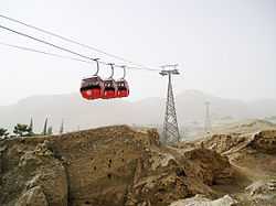
One of Jericho’s primary sources of income is Christian tourism. A cable car takes Christian pilgrims up the hill to the Mount of Temptation, topped by a Greek Orthodox monastery with panoramic views of the region.[3] In 2010, Jericho, with its proximity to the Dead Sea, was declared the most popular destination among Palestinian tourists.[71]
Agriculture is another source of income, with banana groves ringing the city.[3]
The Jericho Agro-Industrial Park is a public-private enterprise being developed in the Jericho area. Agricultural processing companies are being offered financial concessions to lease plots of land in the park in a bid to boost Jericho's economy.[72]
Schools and religious institutions
In 1925, Christian friars opened a school for 100 pupils that became the Terra Santa School. The city has 22 state schools and a number of private schools.[68]
Health care
In April 2010, the United States Agency for International Development (USAID) held a groundbreaking ceremony for the renovation of the Jericho Governmental Hospital. USAID is providing $2.5 million in funding for this project.[73]
Archaeology
The first excavations of the site were made by Charles Warren in 1868. Ernst Sellin and Carl Watzinger excavated Tell es-Sultan and Tulul Abu el-'Alayiq between 1907–1909 and in 1911, and John Garstang excavated between 1930 and 1936. Extensive investigations using more modern techniques were made by Kathleen Kenyon between 1952 and 1958. Lorenzo Nigro and Nicolo Marchetti conducted excavations in 1997-2000. Since 2009 the Italian-Palestinian archaeological project of excavation and restoration was resumed by Rome "La Sapienza" University and Palestinian MOTA-DACH under the direction of Lorenzo Nigro and Hamdan Taha (www.lasapienzatojericho.it).
Tell es-Sultan
The earliest settlement was located at the present-day Tell es-Sultan (or Sultan's Hill), a couple of kilometers from the current city. In Arabic and in Hebrew, tell means "mound" - consecutive layers of habitation built up a mound over time, as is common for ancient settlements in the Middle East and Anatolia. Jericho is the type site for the Pre-Pottery Neolithic A (PPN A) and B periods.
Stone Age

Epipaleolithic—construction at the site appears to predate the invention of agriculture, with the construction of Natufian culture structures beginning earlier than 9000 BC, the very beginning of the Holocene epoch in geologic history.[7]
Pre-Pottery Neolithic A (8350 – 7370 BC); sometimes it is called Sultanian. The site is a 40,000 square metres (430,000 sq ft) settlement surrounded by the Wall of Jericho, with the Tower of Jericho in the centre of one wall. Along with Tell Qaramel, this is one of the first walls ever to be discovered, thus suggesting some kind of social organization. The town contained round mud-brick houses, yet no street planning.[74] The identity and number of the inhabitants (some sources say 2000–3000 dwellers)[9] of Jericho during the PPN A period is still under debate, though it is known that they had domesticated emmer wheat, barley and pulses and hunted wild animals.
Pre-Pottery Neolithic B, 7220 to 5850 BC (but carbon-14-dates are few and early). Expanded range of domesticated plants. Possible domestication of sheep. Apparent cult involving the preservation of human skulls, with facial features reconstructed from plaster and eyes set with shells in some cases.
After the PPN A settlement-phase there was a settlement hiatus of several centuries, then the PPN B settlement was founded on the eroded surface of the tell. The architecture consisted of rectilinear buildings made of mudbricks on stone foundations. The mudbricks were loaf-shaped with deep thumb prints to facilitate bounding. No building has been excavated in its entirety. Normally, several rooms cluster around a central courtyard. There is one big room (6.5 m × 4 m (21.33 ft × 13.12 ft) and 7 m × 3 m (22.97 ft × 9.84 ft)) with internal divisions, the rest are small, presumably used for storage. The rooms have red or pinkish terrazzo-floors made of lime. Some impressions of mats made of reeds or rushes have been preserved. The courtyards have clay floors.
Kathleen Kenyon interpreted one building as a shrine. It contained a niche in the wall. A chipped pillar of volcanic stone that was found nearby might have fit into this niche.
The dead were buried under the floors or in the rubble fill of abandoned buildings. There are several collective burials. Not all the skeletons are completely articulated, which may point to a time of exposure before burial. A skull cache contained seven skulls. The jaws were removed and the faces covered with plaster; cowries were used as eyes. A total of ten skulls were found. Modelled skulls were found in Tell Ramad and Beisamoun as well.
Other finds included flints, such as arrowheads (tanged or side-notched), finely denticulated sickle-blades, burins, scrapers, a few tranchet axes, obsidian, and green obsidian from an unknown source. There were also querns, hammerstones, and a few ground-stone axes made of greenstone. Other items discovered included dishes and bowls carved from soft limestone, spindle whorls made of stone and possible loom weights, spatulae and drills, stylised anthropomorphic plaster figures, almost life-size, anthropomorphic and theriomorphic clay figurines, as well as shell and malachite beads.
In the late 4th millennium BC, Jericho was occupied during Neolithic 2 and the general character of the remains on the site link it culturally with Neolithic 2 sites in the West Syrian and Middle Euphrates groups. This link is established by the presence of rectilinear mud-brick buildings and plaster floors that are characteristic of the age.
Bronze Age
During the Middle Bronze Age Jericho was a small prominent city of the Canaan region, reaching its greatest Bronze Age extent in the period from 1700 to 1550 BC. It seems to have reflected the greater urbanization in the area at that time, and has been linked to the rise of the Maryannu, a class of chariot-using aristocrats linked to the rise of the Mitannite state to the north. Kathleen Kenyon reported “...the Middle Bronze Age is perhaps the most prosperous in the whole history of Kna'an. ... The defenses ... belong to a fairly advanced date in that period” and there was “a massive stone revetment... part of a complex system” of defenses (pp. 213–218).[75] Bronze-age Jericho fell in the 16th century at the end of the Middle Bronze Age, the calibrated carbon remains from its City-IV destruction layer dating to 1617–1530 BC. Notably this carbon dating c. 1573 BC confirmed the accuracy of the stratigraphical dating c. 1550 by Kenyon.
Synagogues

The Jericho Synagogue in the Royal Maccabean winter palace at Jericho dates from 70-50 BC.
A synagogue dating to the late 6th or early 7th century AD was discovered in Jericho in 1936, and was named Shalom Al Yisrael Synagogue, or "peace unto Israel," after the central Hebrew motto in its mosaic floor. It was controlled by Israel after the Six Day War, but after the handover to Palestinian Authority control per the Oslo Accords, it has been a source of conflict. On the night of 12 October 2000, the synagogue was vandalized by Palestinians who burned holy books and relics and damaged the mosaic.[76][77]
The Na'aran synagogue, another Byzantine era construction, was discovered on the northern outskirts of Jericho in 1918. While less is known of it than Shalom Al Yisrael, it has a larger mosaic and is in similar condition.[78]
Sports
The sports team Hilal Areeha plays association football in the West Bank First Division. They play home games in the 15,000 spectator Jericho International Stadium.[79]

Twin towns — Sister cities
Jericho is twinned with:
Notable residents
See also
- al-Auja, Jericho
- Battle of Jericho
- History of pottery in Palestine
- Jawa, Jordan
- Jericho royal winter palaces
- Mevo'ot Yericho
- Wall of Jericho
References
- ↑ Elected City Council Municipality of Jericho. Retrieved 8 March 2008.
- ↑ 2.0 2.1 2007 PCBS Census. Palestinian Central Bureau of Statistics (PCBS).
- ↑ 3.0 3.1 3.2 The lost Jewish presence in Jericho, Jerusalem Post
- ↑ Palestinian farmers ordered to leave lands Al Jazeera. 29 August 2012
- ↑ Gates, Charles (2003). "Near Eastern, Egyptian, and Aegean Cities", Ancient Cities: The Archaeology of Urban Life in the Ancient Near East and Egypt, Greece and Rome. Routledge. p. 18. ISBN 0-415-01895-1.
Jericho, in the Jordan River Valley in Palestine, inhabited from ca. 9000 BC to the present day, offers important evidence for the earliest permanent settlements in the Near East.
- ↑ 6.0 6.1 Murphy-O'Connor, 1998, p. 288.
- ↑ 7.0 7.1 7.2 Freedman et al., 2000, p. 689–671.
- ↑ Akhilesh Pillalamarri (18 April 2015). "Exploring the Indus Valley's Secrets". The diplomat. Retrieved 18 April 2015.
- ↑ 9.0 9.1 "Jericho", Encyclopædia Britannica
- ↑ "What is the oldest city in the world?".
- ↑ "The world's 20 oldest cities".
- ↑ Bromiley, 1995, p. 715.
- ↑ "Strong's Bible Dictionary". Htmlbible.com. Retrieved 31 March 2011.
- ↑ Schreiber, 2003, p. 141.
- ↑ 15.0 15.1 15.2 15.3 15.4 15.5 15.6 15.7 15.8 15.9 Ring et al., 1994, p. 367–370.
- ↑ Bromiley, 1995, p. 1136.
- ↑ "Bibliotheca Sacra 132" (PDF). 1975. pp. 327–42.
- ↑ Editors, Mandatory (24 January 2013). "travel, history, civilizations, greatest cities, largest cities, Jericho". Mandatory. Retrieved 12 March 2013.
- ↑ Mithen, Steven (2006). After the ice: a global human history, 20,000-5000 BC (1st Harvard University Press pbk. ed. ed.). Cambridge, Mass.: Harvard University Press. p. 57. ISBN 0-674-01999-7.
- ↑ "Prehistoric Cultures". Museum of Ancient and Modern Art. 2010. Retrieved 5 September 2013.
- ↑ "Ancient Jericho: Tell es-Sultan". UNESCO World Heritage Centre. 2012. Retrieved 5 September 2013.
- ↑ Mithen, Steven (2006). After the ice: a global human history, 20,000-5000 BC (1st Harvard University Press pbk. ed. ed.). Cambridge, Mass.: Harvard University Press. p. 54. ISBN 0-674-01999-7.
- ↑ 23.0 23.1 Akkermans, Peter M. M; Schwartz, Glenn M. (2004). The Archaeology of Syria: From Complex Hunter-Gatherers to Early Urban Societies (c.16,000-300 BC). Cambridge University Press. p. 57. ISBN 978-0521796668.
- ↑ Mithen, Steven (2006). After the ice: a global human history, 20,000-5000 BC (1st Harvard University Press pbk. ed. ed.). Cambridge, Mass.: Harvard University Press. p. 59. ISBN 0-674-01999-7.
- ↑ Janson and Janson, 2003.
- ↑ Scneller, 1994, p. 138.
- ↑ 27.0 27.1 27.2 Thomas A. Holland (1997). "Jericho". In Eric M. Meyers. The Oxford Encyclopedia of Archaeology in the Near East. Oxford University Press. pp. 220–224.
- ↑ Kathleen M. Kenyon (1957). Digging up Jericho: The Results of the Jericho Excavations, 1952-1956. New York: Praeger. p. 229.
- ↑ Piotr Bienkowski (1986). Jericho in the Late Bronze Age. Warminster. pp. 120–125.
- ↑ Bryant G. Wood (1990). "Did the Israelites conquer Jericho?". Biblical Archaeology Review 16 (2): 44–59.
- ↑ William G. Dever (1990). "Letter". Biblical Archaeology Review 16 (5): 18.
- ↑ Piotr Bienkowski (1990). "Jericho was destroyed in the Middle Bronze Age, not the Late Bronze Age". Biblical Archaeology Review 16 (5): 45–46, 69.
- ↑ Bryant G. Wood (1990). "Dating Jericho's destruction: Bienkowski is wrong on all counts". Biblical Archaeology Review 16 (5): 45, 47–49, 68–69.
- ↑ Bruins, HJ and van der Plicht, J (1995). Tell es-Sultan (Jericho): Radiocarbon results of short-lived cereal and multiyear charcoal samples from the end of the Middle Bronze Age, Radiocarbon Vol. 37, pp. 213–220. A radiocarbon date of 3306±7 BP was obtained for grains probably remaining from the final few years. This corresponds to a date range (2 sigma) of 1617–1530 BC by the 2004 calibration scale.
- ↑ 1 Macc 9:50
- ↑ 36.0 36.1 36.2 36.3 36.4 Murphy-O'Connor, 1998, pp. 289–291.
- ↑ 37.0 37.1 Jericho - (Ariha) Studium Biblicum Franciscum - Jerusalem.
- ↑ "Blind Bartimaeus Receives his Sight, Mark 10:46". Biblegateway.com. Retrieved 31 March 2011.
- ↑ "A Blind Beggar Receives His Sight Luke 18:35". Biblegateway.com. Retrieved 31 March 2011.
- ↑ "Jesus Heals Two Blind Beggars, Matthew 20:29". Biblegateway.com. Retrieved 31 March 2011.
- ↑ "The Parable of the Good Samaritan Luke 10:25". Biblegateway.com. Retrieved 31 March 2011.
- ↑ http://wesley.nnu.edu/john-wesley/john-wesleys-notes-on-the-bible/notes-on-the-gospel-according-to-st-luke/#Chapter+X
- ↑ 43.0 43.1 Losch, 2005, p. 117–118.
- ↑ Several hadith collections: e.g. Bukhari, Sahih as translated Muḥammad Muḥsin Khân, The Translation of the Meanings of Sahih al-Bukhari (India: Kitab Bhavan, 1987) 3.39.531 and 4.53.380, and Muslim Sahih trans. Abdul Hamid Siddiqui (Lahore: Kazi Publications, 1976) 10.3763.
- ↑ The Maronite Chronicle, written during Mu'awiya's caliphate. Note that for propaganda reasons it dates the earthquake to the wrong year: Andrew Palmer, The Seventh Century in the West-Syrian Chronicles (Liverpool: Liverpool University Press, 1993), 30, 31, 32.
- ↑ “The Pilgrimage of Arculf in the Holy Land”, De Locis Sanctis as translated by Rev. James Rose MacPherson (W. London: BD. 24, Hanover Square, 1895), ch. I.11.
- ↑ Shahin, 2005, p. 285.
- ↑ Shahin, 2005, p. 283.
- ↑ al-Muqaddasi quoted in Le Strange, 1890, p.39.
- ↑ Hull, 1855.
- ↑ al-Hamawi and Abu-l Fida quoted in Le Strange, 1890, p.397.
- ↑ Singer, 2002, p. 120.
- ↑ Graham, Peter. A Topographical Dictionary of Palestine. London, 1836. Page 122.
- ↑ Friling and Cummings, 2005, p. 65.
- ↑ "Israel hit by fifth minor quake in a week". Ya Libnan. 22 October 2013. Retrieved 27 December 2013.
- ↑ Benvenisti, 1998, pp. 27-28.
- ↑ 57.0 57.1 At 10th anniversary, a far poorer Palestinian Authority
- ↑ Simons, Marlise (30 April 1994). "Gaza-Jericho Economic Accord Signed by Israel and Palestinians". Jericho (West Bank); Middle East; Gaza Strip: New York Times. Retrieved 31 March 2011.
- ↑ Ġānim, Asʻad (2010), Palestinian Politics After Arafat: A Failed National Movement, Indiana University Press, p. 35, ISBN 9780253354273
- ↑ ARIJ & LRC, 20 March 2001, The Tightening of the Siege on Jericho: Israel Employs a New Policy of Trench Digging
- ↑ Israel holds militant after siege 14 March 2006 BBC News
- ↑ Jerusalem Post 4 August 2008 IDF: Hilles clan won't boost terrorism Yaacov Katz And Khaled Abu Toameh
- ↑ Training Center for Palestinian Authority Security Forces Opens in Jericho
- ↑ 64.0 64.1 64.2 Holman, 2006, p. 1391.
- ↑ Hadawi, 1970, p.57
- ↑ Palestinian Population by Locality and Refugee Status Palestinian Central Bureau of Statistics (PCBS).
- ↑ Palestinian Population by Locality, Sex and Age Groups in Years (PCBS).
- ↑ 68.0 68.1 Jericho: A small Christian community and their school
- ↑ Gaza-Jericho Economic Accord Signed by Israel and Palestinians
- ↑ Walls going up in Jericho – construction of casino-hotel Palestinians, Israelis have role in project
- ↑ Palestinians aim to push tourism beyond Bethlehem
- ↑ Jericho business park aims to inch Palestine towards sustainability, The Guardian
- ↑ USAID to Renovate the Jericho Governmental Hospital
- ↑ "Old Testament Jericho". Web.archive.org. 20 February 2008. Archived from the original on 20 February 2008. Retrieved 31 March 2011.
- ↑ Kenyon, Kathleen "Digging up Jericho"(London, 1957)
- ↑ "The Palestinian Authority and the Jewish Holy Sites". JCPA. Retrieved 21 February 2010.
- ↑ "Jewish life in Jericho". Jewishjericho.org.il. Retrieved 5 May 2009.{}
- ↑ "Jewish life in Jericho". Jewishjericho.org.il. Retrieved 5 May 2009.{}
- ↑ World Stadiums
- ↑ "Pisa - Official Sister Cities". Comune di Pisa, Via degli Uffizi, 1 - 56100 Pisa centralino: +39 050 910111. Retrieved 16 December 2008.
- ↑ "Kragujevac Twin Cities". 2009 Information service of Kragujevac City. Retrieved 21 February 2009.
- ↑ "Jerikó lett Eger új testvérvárosa". Index.hu. Retrieved 7 September 2013.
Bibliography
- Benvenisti, Meron (1998). City of Stone: The Hidden History of Jerusalem. University of California Press. ISBN 978-0-520-20768-4.
- Bromiley, Geoffrey W. (1995). The International Standard Bible Encyclopedia: E-J. Wm. B. Eerdmans Publishing. ISBN 978-0-8028-3782-0.
- Finkelstein, Israel; Silberman, Neil Asher (2002). The Bible Unearthed. Touchstone. ISBN 0-684-86913-6.
- Freedman, David Noel; Myers, Allen C.; Beck, Astrid B. (2000). Eerdmans Dictionary of the Bible. Wm. B. Eerdmans Publishing. ISBN 978-0-8028-2400-4.
- Friling, Tuvia; Cummings, Ora (2005). Arrows in the Dark: David Ben-Gurion, the Yishuv Leadership, and Rescue Attempts During the Holocaust. University of Wisconsin Press. ISBN 978-0-299-17550-4.
- Gates, Charles (2003). Ancient Cities: The Archaeology of Urban Life in the Ancient Near East and Egypt, Greece and Rome.
- Holman (2006). Holman Illustrated Study Bible-HCSB: Holman Christian Standard Bible. Broadman & Holman Publishers. ISBN 978-1-58640-275-4.
- Hull, Edward (1855). Mount Seir, Sinai and Western Palestine. Richard Bently and Sons.
- Janson, Horst Woldemar; Janson, Anthony F. (2003). History of Art: The Western Tradition. Prentice Hall. ISBN 0-13-182895-9.
- Kenyon, Kathleen (1957). Digging Up Jericho.
- LeStrange, Guy (1890). Palestine Under the Moslems. Alexander P. Watt for the Committee of the Palestine Exploration Fund.
- Losch, Richard R. (2005). The Uttermost Part of the Earth: A Guide to Places in the Bible. Wm. B. Eerdmans Publishing. ISBN 978-0-8028-2805-7.
- Murphy-O'Connor, Jerome (1998). The Holy Land: An Oxford Archaeological Guide from Earliest Times to 1700. Oxford University Press. ISBN 978-0-19-288013-0.
- Ring, Trudy; Salkin, Robert M.; Berney, K. A.; Schellinger, Paul E. (1994). International dictionary of historic places. Taylor & Francis. ISBN 978-1-884964-03-9.
- Scheller, William (1994). Amazing Archaeologists and Their Finds. The Oliver Press, Inc. ISBN 978-1-881508-17-5.
- Schreiber, Mordecai; Schiff, Alvin I.; Klenicki, Leon (2003). The Shengold Jewish Encyclopedia. Schreiber Pub. ISBN 978-1-887563-77-2.
- Shahin, Mariam (2005). Palestine: A Guide. Interlink Books. ISBN 978-1-56656-557-8.
- Stacey, D. 'Hedonists or pragmatic agriculturalists? Reassessing Hasmonean Jericho', Levant, 38 (2006), 191–202.
External links
| Wikimedia Commons has media related to Jericho. |
- Jericho Municipality Official Website
- Jericho Municipality Official Website Historical site
- Jericho Cable Car
- Resources on Biblical Archaeology
- Jericho: Tel es-Sultan
- The walls of Jericho fell in 1550 BC
| ||||||||||||||||||||

| ||||||||||||||||||
| |||||||||||||||||||||

| ||||||||||||||