Jeita
This article is about the town. For the grotto, see Jeita Grotto. For the Japanese electronics association JEITA, see Japan Electronics and Information Technology Industries Association.
Coordinates: 33°57′14″N 35°38′36″E / 33.95389°N 35.64333°E
| Jeita | |
|---|---|
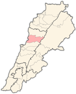
 Jeita Location in Lebanon | |
| Coordinates: 33°57′14″N 35°38′36″E / 33.95389°N 35.64333°E | |
| Country |
|
| Governorate | Mount Lebanon Governorate |
| District | Keserwan District |
| Time zone | EET (UTC+2) |
| • Summer (DST) | EEST (UTC+3) |
Jeita (also spelled Jaaita or Jaita; Arabic: جعيتا Jʿītā) is a Lebanese town located in the Keserwan District in the Mount Lebanon Governorate. The town is about 20 kilometres (12 mi) north of Beirut.[1] It is famous for the Jeita Grotto which is a popular tourist attraction, as well as the Nahr al-Kalb, a river that runs from a spring near the grotto emptying into the Mediterranean Sea. Most of the town's inhabitants are Maronites.
The name Jeita is derived from the Aramaic word Ge’itta, meaning "roar" or "noise".[2]
References
- ↑ Jaaita - Localiban. Retrieved on July 24, 2009
- ↑ Lebanese Maronite villages or towns. Retrieved on July 24, 2009
| |||||||||||||||||