Jefferson Township, Preble County, Ohio
| Jefferson Township, Ohio | |
|---|---|
| Township | |
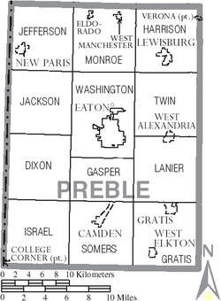 Municipalities and townships of Preble County. | |
| Coordinates: 39°51′22″N 84°46′14″W / 39.85611°N 84.77056°WCoordinates: 39°51′22″N 84°46′14″W / 39.85611°N 84.77056°W | |
| Country | United States |
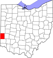
| State | Ohio |
| County | Preble |
| Area | |
| • Total | 35.5 sq mi (91.8 km2) |
| • Land | 35.3 sq mi (91.5 km2) |
| • Water | 0.1 sq mi (0.4 km2) |
| Elevation[1] | 1,161 ft (354 m) |
| Population (2000) | |
| • Total | 3,449 |
| • Density | 97.7/sq mi (37.7/km2) |
| Time zone | Eastern (EST) (UTC-5) |
| • Summer (DST) | EDT (UTC-4) |
| FIPS code | 39-38780[2] |
| GNIS feature ID | 1086851[1] |

Jefferson Township is one of the twelve townships of Preble County, Ohio, United States. The 2000 census found 3,449 people in the township, 1,826 of whom lived in the unincorporated portions of the township.[3]
Geography
Located in the northwestern corner of the county, it borders the following townships:
- Harrison Township, Darke County - north
- Butler Township, Darke County - northeast corner
- Monroe Township - east
- Washington Township - southeast corner
- Jackson Township - south
- Wayne Township, Wayne County, Indiana - west
- Franklin Township, Wayne County, Indiana - northwest
The village of New Paris is located in western Jefferson Township.
Name and history
It is one of twenty-four Jefferson Townships statewide.[4]
Jefferson Township was organized in 1809, and named for Thomas Jefferson, third President of the United States.[5]
Government
The township is governed by a three-member board of trustees, who are elected in November of odd-numbered years to a four-year term beginning on the following January 1. Two are elected in the year after the presidential election and one is elected in the year before it. There is also an elected township fiscal officer,[6] who serves a four-year term beginning on April 1 of the year after the election, which is held in November of the year before the presidential election. Vacancies in the fiscal officership or on the board of trustees are filled by the remaining trustees.
References
- ↑ 1.0 1.1 "US Board on Geographic Names". United States Geological Survey. 2007-10-25. Retrieved 2008-01-31.
- ↑ "American FactFinder". United States Census Bureau. Retrieved 2008-01-31.
- ↑ Preble County, Ohio — Population by Places Estimates Ohio State University, 2007. Accessed 15 May 2007.
- ↑ "Detailed map of Ohio" (PDF). United States Census Bureau. 2000. Retrieved 2007-02-16.
- ↑ Kilbourn, John (1833). "The Ohio Gazetteer, or, a Topographical Dictionary". Scott and Wright. p. 256. Retrieved 12 December 2013.
- ↑ §503.24, §505.01, and §507.01 of the Ohio Revised Code. Accessed 4/30/2009.
External links
| |||||||||||||||||||||||||||||||||