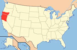
Jefferson (proposed Pacific state)
| State of Jefferson (proposed) | |||||
|---|---|---|---|---|---|
| |||||
| Nickname(s): State of Mind | |||||
 | |||||
| Official language | English | ||||
| Demonym | Jeffersonian | ||||
| Capital | Determined during the Jefferson Constitutional Convention | ||||
| Area | |||||
| - Total |
73,656 sq mi (190,090 km2) | ||||
| - Width | 250 miles (402 km) | ||||
| - Length | 295 miles (475 km) | ||||
| - % water | Unknown | ||||
| - Latitude | 38°45'N to 43°57'N | ||||
| - Longitude | 119°18'W to 124°25'W | ||||
| Population | |||||
| - Total | 2,313,958 | ||||
| - Density |
32.42/sq mi (19.52/km2) Ranked 42th (hypothetical) | ||||
| Elevation | |||||
| - Highest point |
Mount Shasta 14,179 ft (4316.58 m) | ||||
| - Mean | 7,081 ft (2158.29 m) | ||||
| - Lowest point | sea level | ||||
| Admission to Union | (Not admitted) | ||||
| Governor | None | ||||
| Lieutenant Governor | None | ||||
| Legislature |
None | ||||
| - Upper house | Senate | ||||
| - Lower house | Assembly | ||||
| U.S. Senators | None | ||||
| U.S. House delegation | List | ||||
| Time zone | Pacific: UTC-8/-7 | ||||
| Abbreviations | , | ||||
| Website |
www | ||||
.svg.png)
The State of Jefferson is a proposed U.S. state that would span the contiguous, mostly rural area of southern Oregon and northern California, where several attempts to separate from Oregon and California, respectively, have taken place in order to gain statehood.
This region on the Pacific Coast is the most famous of several that have sought to adopt the name of Thomas Jefferson, the third President of the United States. Thomas Jefferson sent the Lewis and Clark expedition into the Pacific Northwest in 1803, and envisioned the establishment of an independent nation in the western portion of North America which he dubbed the "Republic of the Pacific",[1] hence the association of his name with regional autonomy. The independence movement (rather than statehood) is instead known as Cascadia.
The name "Jefferson" has also been used for other proposed states: the name was proposed in the 19th century for Jefferson Territory (roughly modern Colorado), as well as in 1915 in a bill in the Texas legislature for a proposed state that would be created from the Texas Panhandle region.[2][3]
20th century
In October 1941, the mayor of Port Orford, Oregon, Gilbert Gable, said that the Oregon counties of Curry, Josephine, Jackson, and Klamath should join with the California counties of Del Norte, Siskiyou, and Modoc to form a new state, later named Jefferson.[4]
On November 27, 1941, a group of young men gained national media attention when, brandishing hunting rifles for dramatic effect, they stopped traffic on U.S. Route 99 south of Yreka, the county seat of Siskiyou County, and handed out copies of a Proclamation of Independence, stating that the state of Jefferson was in "patriotic rebellion against the States of California and Oregon" and would continue to "secede every Thursday until further notice."[5]
The state split movement ended quickly, though not before John C. Childs of Yreka was inaugurated as the governor of the State of Jefferson.[6] The first blow was the death of Mayor Gable on December 2, followed by the attack on Pearl Harbor on December 7. Those in favor of splitting the state focused their efforts on the war effort, which crippled the movement. Coincidentally, the "state of Jefferson" was one of the few places in the continental USA to be the subject of an attack during World War II, when Japanese pilot Nobuo Fujita dropped bombs on the Oregon Coast near Brookings on September 9, 1942.[7]
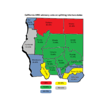
In 1992, State Assemblyman Stan Statham place an advisory vote[8] in 31 counties asking if the state should be split into two. All of the proposed Jefferson counties voted in favor of the split[9] (except Humboldt County which did not have the issue on the ballot.) Based on these results, Statham introduced legislation in California[10] in an attempt to split the state, but the bill died in committee.
21st century
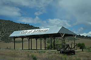
Jefferson is commemorated by the State of Jefferson Scenic Byway between Yreka and O'Brien, Oregon, which runs 109 miles along State Route 96 and U.S. Forest Service Primary Route 48. Near the California - Oregon border, a turnout provides scenic views of the Klamath River valley and three informative display signs about the republic. The region retains this identity reinforced by institutions such as Jefferson Public Radio.
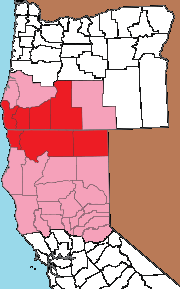
As of the 2010 Census, if the Jefferson counties were a state (original 1941 counties), the state's population would be 457,859: smaller than any state at the time. Approximately 82% of those residents live in Oregon. Its land area would be 21,349.76 square miles (55,295.6 km2) – a little smaller than West Virginia. The area is almost evenly divided between Oregon and California. Its population density would be 21.44 inhabitants per square mile (8.28/km2) – a little more than Idaho.[11] With the addition of the more modern Jefferson movement (Coos and Douglas and Lake Counties in Oregon, and Humboldt, Trinity, Shasta, Lassen, Mendocino, Lake, Tehama, Plumas, Glenn, Butte, Colusa, Sierra, Sutter, Yuba, Nevada, Placer and El Dorado Counties in California), the population as of the 2010 Census would be 2,313,958, making it the 36th most populous state in the US.
In 1989, KSOR, the National Public Radio member station based at Southern Oregon University in Ashland, near Medford, rebranded itself as Jefferson Public Radio. It had built a massive network of affiliated radio stations over the previous decade, and the network's management had decided to promote its service area as generally coextensive with the original State of Jefferson land region.[12]
The Modern State Split Movement of 2013
Based on Article IV, Section 3 of the US Constitution,[13] supporters of the state split of seven southern Oregon and twenty northern California counties are actively seeking remedy for the loss of statewide representation based on the basket of court cases know as Reynolds v. Sims. In Reynold v. Sims,[14] the Warren Court stripped 30 states of the republican model of government guaranteed in Article IV, Section 4[13] of the US Constitution. Where states once had one or nearly one Senator per county, Warren opined that all state elections were to be conducted under court supervision and that both houses would be selected by population. This made the republican form of government unconstitutional at the state level. On the federal level, the Senate in the US Congress still has two Senators from each state regardless of size or population. This was the result of the "Great Compromise of 1787"[15] which guaranteed each state, no matter how small, two Senators and the House of Representatives would be apportioned by population. Without the Great Compromise, there likely would not have been a Constitution as the smaller states would have refused to sign in the absence of a check and balance against the larger more populated states.
It started on September 3, 2013, when the Siskiyou County Board of Supervisors voted 4–1 in favor of withdrawal from California to form a proposed state named Jefferson.[16][17][18] The proposal was joined by the Modoc County Board of Supervisors (September 24)[19] and Glenn County Board of Supervisors (January 21, 2014).[20][21] On April 15, 2014 Yuba County supervisors joined the State of Jefferson movement to separate from California and create a new state of Jefferson.[22] On July 15, 2014 The Tehama County Board of Supervisors voted unanimously to adopt a resolution supporting the declaration of withdrawal from California[23] based on an advisory vote taken on June 6, 2014 where the public voted 56% to 44% in favor of splitting the state.[24] On July 22, 2014 the Board of Supervisors of Sutter County unanimously adopted a resolution supporting a declaration and petition to the Legislature to withdraw from California to redress a lack of representation.[25] On March 3, 2015, Lake County supervisors voted 3-2[26][27] to submit the question of secession to voters and on March 17, Lassen County supervisors made a similar declaration[28] that also has the voters deciding in 2016.[29] The Jefferson Declaration Committee is reportedly aiming to get at least 12 counties in support.[16]
On October 24, 2014, Modoc and Siskiyou Counties delivered their declarations[30] for independence from the state of California to the California Secretary of State's office. On January 15, 2015, three more counties, Glenn, Tehama, and Yuba Counties submitted their official declarations as well.[31]
The movement has groups in all 20 proposed California counties for the state split as well a growing number of groups in the seven counties in Oregon (including the four that were part of the original 1941 movement.)
Flag and seal
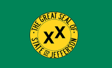
The field of the flag is green, and the charge is the Seal of the State of Jefferson: a gold mining pan with the words "The Great Seal Of State Of Jefferson" engraved into the lip, and two Xs askew of each other. The two Xs are known as the "Double Cross" and signify the two regions' "sense of abandonment" from the central state governments, in both Salem, Oregon and Sacramento, California.
See also
- Jefferson (proposed Mountain state)
- Jefferson (proposed Southern state)
- Absaroka (proposed state)
- Franklin (proposed state)
- Lincoln (proposed Northwestern state)
- Lincoln (proposed Southern state)
- Superior (proposed U.S. state), proposed Midwestern state
- Cascadia (independence movement)
- American Redoubt
- Secession
- Northwest Territorial Imperative
- List of U.S. state partition proposals
References
- ↑ "Beginnings of Self-Government". End of the Oregon Trail Interpretive Center. Archived from the original on 2008-10-12. Retrieved 2011-07-21.
- ↑ http://www.tshaonline.org/handbook/online/articles/mqd01
- ↑ Division of Texas from the Handbook of Texas Online
- ↑ Hall, Christopher (September 2003). "Jefferson County: The State that Almost Seceded". Via: AAA Traveler's Companion (AAA Northern California, Nevada & Utah). Retrieved 2015-02-21.
- ↑ D'Souza, Tony (December 11, 2008). "State of Jefferson dreams were dashed by Pearl Harbor". Mount Shasta Herald. Retrieved 2015-02-21.
- ↑ Holt, Tim (June 24, 2011). "A modest proposal -- downsize California!". The San Francisco Chronicle. Retrieved 2015-02-21.
- ↑ "Bombs Fall on Oregon: Japanese Attacks on the State". Oregon State Archives, Office of the Secretary of State. January 31, 2008. Retrieved 2015-02-21.
- ↑ "CALIFORNIA ELECTIONS '92 : 31 Counties to Vote on the Divisive Issue of Splitting the State : Government: Secession has backers in the rural north, but the advisory plebiscite has no legal effect.". Los Angeles Times. May 30, 1992. Retrieved 2015-04-25.
- ↑ "Historical Efforts to Split California into Multiple States". Gary and Deborah Aufdenspring. Retrieved 2015-04-25.
- ↑ "The "Upstate California" campaign is déjà vu all over again for Stan Statham". Sacramento News & review. January 3, 2002. Retrieved 2015-04-25.
- ↑ Using the 2010 Census QuickFacts figures for each of the following counties: Curry, Josephine, Jackson, Klamath, Del Norte, Siskiyou, Modoc.
"DataSet.txt". State & County QuickFacts. U.S. Census Bureau. Retrieved November 16, 2012. (See "Download the Database" for an explanation of this data set.) - ↑ "State of Jefferson - Jefferson Public Radio".
- ↑ 13.0 13.1 "Article IV". Cornell University Law Library. Retrieved 2015-04-25.
- ↑ "Reynolds v. Sims 377 U.S. 533 (1964)". Justia US Supreme Court. 1964-06-15. Retrieved 2015-04-25.
- ↑ "The Great Compromise of 1787". US Senate. 1964-06-15. Retrieved 2015-04-25.
- ↑ 16.0 16.1 Longoria, Sean, Siskiyou supervisors support withdrawal from California, Redding Record Searchlight, September 4, 2013, accessed September 4, 2013
- ↑ Mather, Kate, Siskiyou County votes to pursue secession from California, Los Angeles Times, September 4, 2013, accessed September 4, 2013
- ↑ Northern California County Board Votes For Secession From State, CBS, San Francisco, September 4, 2013
- ↑ "Modoc County joins Siskiyou in state of Jefferson bid for secession". 2013-09-24. Retrieved 2013-09-25.
- ↑ "Supervisors vote to join secession effort". 2014-01-21. Retrieved 2014-01-22.
- ↑ "State of Jefferson takes root in Glenn County". 2014-01-21. Retrieved 2014-01-22.
- ↑ "Yuba County supervisors endorse State of Jefferson". 2014-04-16. Retrieved 2014-07-31.
- ↑ "Supervisors approve of Jefferson". 2014-07-15. Retrieved 2014-07-31.
- ↑ "Tehama County Voters Approve Advisory Measure To Secede From California". 2014-06-14. Retrieved 2015-04-25.
- ↑ "Sutter County votes for State of Jefferson". 2014-07-23. Retrieved 2014-07-31.
- ↑ "Board votes for Jefferson". Record Bee Community News. 2015-02-17. Retrieved 2015-04-25.
- ↑ "Lake County voters to weigh in on secession". The Press Democrat. 2015-03-15. Retrieved 2015-04-25.
- ↑ "Lassen County Declaration" (PDF). 2015-03-17. Retrieved 2015-04-25.
- ↑ "Lassen County Meeting Summary". 2015-03-17. Retrieved 2015-04-25.
- ↑ "2 California counties ask to form separate state". USA Today. 2014-08-28. Retrieved 2015-04-25.
- ↑ "State of Jefferson brings three more California counties on board". Sacramento Bee. 2015-01-15. Retrieved 2015-04-25.
Further reading
- James T. Rock. The State of Jefferson: the Dream Lives on! Siskiyou County Museum, 1999.
External links
| Wikimedia Commons has media related to State of Jefferson. |
- State of Jefferson Formation site Primary website for the 2013+ modern statehood movement
- Jefferson Declaration Blog Very active movement for withdrawal of the rural northern California counties to form a new state of Jefferson
- Jefferson Public Radio on the State of Jefferson
- State Of Jefferson Home Page Organizing the New Movement
- Jefferson Public Radio
- State of Jefferson by Ian Jones
- The Mythical State of Jefferson by Megan Shaw at Bad Subjects
- A State of Mind:Exploring the untamed wonders of Jefferson by Glenn Garnett at CottageLink Magazine
- A Jefferson State of Mind by Christopher Hall at AAA's Via Magazine
- The Jefferson Proposal Official Jefferson State Joint Committee website
- The State of Jefferson Images of America series (Google Books)
- State of Jefferson Documentary produced by Oregon Public Broadcasting