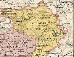
Jashpur State
| Jashpur State जशपुर | |||||
| Princely State of British India | |||||
| |||||
|
Flag | |||||
 | |||||
| History | |||||
| - | Established | 18th century | |||
| - | Accession to the Union of India | 1948 | |||
| Area | |||||
| - | 1901 | 5,045 km2 (1,948 sq mi) | |||
| Population | |||||
| - | 1901 | 132,114 | |||
| Density | 26.2 /km2 (67.8 /sq mi) | ||||
| | |||||
Jashpur State, was one of the princely states of India during the period of the British Raj. The town of Jashpur was the former state's capital. The rulers were Rajputs of the Chauhan dynasty.
After the Independence of India Jashpur State was merged with the princely states of Raigarh, Sakti, Sarangarh and Udaipur to form the Raigarh district of Madhya Pradesh.[1] Now the district of Raigarh is part of Chhattisgarh state.
History
The area of Jashpur State was ruled by a Dom dynasty at the time of the Mughal Empire. Sujan Rai, a son of the Suryavanshi Raja of Banswada in Rajputana, arrived to the place and saw that the population were not satisfied with their ruler, Raibhan Dom. Sujan led a rebellion, defeated the Dom Raja in battle, and killed him, proclaiming himself king.
The rajas of Jashpur accepted the sovereignty of the Bhonsle dynasty of Nagpur State, paying a tribute of 21 buffalos. Before 1818 the Bhonsle placed Jashpur State under the administration of Surguja State. The state became a British protectorate in 1818.[2]
Jashpur was one of the states of the Eastern States Agency. The last ruler of this princely state signed the accession to the Indian Union on 1 January 1948.[3]
Rulers
The rulers of Jashpur State bore the title of 'Raja'.[4]
Rajas
- .... - c.1813 Ranjit Singh (d. c.1813)
- c.1813 - 1826 ....
- 1826 - 18.. Ram Singh
- 24 Oct 1845 - 1900 Pratap Narayan Singh Deo Bahadur (b. c.1822 - d. 19..)
- Apr 1900 - 1924 Bishan Pratap Singh Deo (b. 1864 - d. 19..)
- 1924 - 1926 Deo Saran Singh Ju Deo
- 8 Feb 1926 - 1947 Vijay Bhushan Singh Ju Deo (b. 1926 - d. 1982)
See also
References
- ↑ Publication by Gokhale Institute of Politics and Economics - 1973- Issue 61 - Page 346
- ↑ Malleson, G. B.: An historical sketch of the native states of India, London 1875, Reprint Delhi 1984
- ↑ Rajput Provinces of India - Jashpur (Princely State)
- ↑ Princely States of India A-J
External links
Coordinates: 22°54′N 84°09′E / 22.90°N 84.15°E
| ||||||||||||||||||
