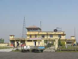
Janakpur Airport
| Janakpur Airport(Domestic) जनकपुर बिमानस्थल | |||||||||||
|---|---|---|---|---|---|---|---|---|---|---|---|
 | |||||||||||
 JKR | |||||||||||
| Summary | |||||||||||
| Airport type | Public | ||||||||||
| Operator | Government | ||||||||||
| Serves | Janakpur, Nepal | ||||||||||
| Elevation AMSL | 256 ft / 78 m | ||||||||||
| Coordinates | 26°42′31″N 085°55′20″E / 26.70861°N 85.92222°E | ||||||||||
| Runways | |||||||||||
| |||||||||||
Janakpur Airport (IATA: JKR, ICAO: VNJP) is an airport serving Janakpur,[1] a city in and the administrative headquarters of the Dhanusa District in the Janakpur Zone in Nepal.
Facilities
The airport resides at an elevation of 256 feet (78 m) above mean sea level. It has one runway designated 09/27 with an asphalt surface measuring 1,006 by 30 metres (3,301 ft × 98 ft).[1]
The airport is capable to handle aircraft from the Nepalese Army Air Service.
Airlines and destinations
| Airlines | Destinations |
|---|---|
| Buddha Air | Kathmandu [3] |
| Gorkha Airlines | Kathmandu [4] |
| Sita Air | Kathmandu [5] |
| Yeti Airlines | Kathmandu [6] |
References
- ↑ 1.0 1.1 1.2 Airport information for VNJP from DAFIF (effective October 2006)
- ↑ Airport information for JKR / VNJP at Great Circle Mapper. Source: DAFIF (effective Oct. 2006).
- ↑ "Flight schedule". Buddha Air. Retrieved 6 June 2010.
- ↑ "Destinations". Gorkha Airlines. Retrieved 8 June 2010.
- ↑ "Destinations". Sita Air. Retrieved 6 June 2010.
- ↑ "Scheduled flights". Yeti Airlines. Retrieved 6 June 2010.