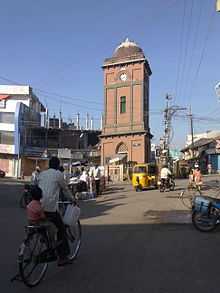
Jagtial
| Jagtial జగిత్యాల | |
|---|---|
| Town | |
.svg.png) Jagtial Location in Telangana, India | |
| Coordinates: 18°48′N 78°56′E / 18.8°N 78.93°ECoordinates: 18°48′N 78°56′E / 18.8°N 78.93°E | |
| Country | India |
| State | Telangana |
| District | Karimnagar |
| Region | Deccan |
| Named for | Mr.Jack and Mr.Tal |
| Government | |
| • Body | Municipality |
| • M.L.A | T. Jeevan Reddy |
| • M.P | K. Kavitha |
| Area | |
| • Total | 45 km2 (17 sq mi) |
| Area rank | 3rd (in disctrict) |
| Elevation | 264 m (866 ft) |
| Population (2011)[1] | |
| • Total | 96,470 |
| • Rank | 3rd (in district) 12th (in telangana state) |
| • Density | 2,100/km2 (5,600/sq mi) |
| Languages | |
| • Official | Telugu |
| Time zone | IST (UTC+5:30) |
| PIN | 505327 |
| Telephone code | 08724 |
| Vehicle registration | TS 02 |
| Website | www.jagtial.com |
Jagtial is municipal town in Karimnagar district of Telangana, India.[2]

Geography
Jagtial is located at 18°48′N 78°56′E / 18.8°N 78.93°E. It has an average elevation of 264 meters (866 feet).
Telugu, Urdu, Hindi, and English are widely spoken languages in Jagtial.
Demographics
As of 2011 Census of India, the town had a population of 96,470. The average literacy rate stands at 78.61% with 67,931 literates, significantly higher than the national average of 73.00%.[3]
Economy
The economy of Jagtial is purely based on commercial and retail consumer business. The town is considered to be a shopping hub for the surrounding towns and for North Telangana and a majority of the trading community conduct business related to groceries, clothing, pharmaceuticals, iron and hardware.In case of industrial imports,the town should import from Jammikunta,which is the only industrial city in the district.
Farmers from the surrounding villages sell their crop harvest and vegetables products in the Jagityal market.
Transport
Road
Jagtial have state operated TSRTC bus depot with more than 150 buses for public transport. It is well connected by road network. This is major division in Karimnagar district. Telangana State Road Transport Corporation runs buses from Jagtial to Karimnagar, Nizamabad, Warangal, [[Mumbai-Borivali.]Bheewandi-Maharastra.], Hyderabad, Bhadrachalam, Tirupati, Vijayawada, Bengaluru, Pamur and private Buses runs From Jagtial to Mumbai(Worli)etc. National Highway 63 passing through the town. Local transportation is autorickshaws. New highway Jagital-Warangal-Khammam-Kodad 4lane road has been sanctioned
Rail
Railway station location is Lingampet Village of Jagtial Mandal. The new Jagtial–Karimnagar broad gauge railway line (nearly 49 km) was laid.
Education
Jagtial is the center of higher-education for its neighbouring villages. There are Intermediate, Degree, Engineering, Medical, and Literature Colleges. Jagtial is the now hub of Campuses like Acharya Jayashankar Agricultural University, Agril. College, Agril.Polytechnic College, National Academy of Construction(NAC), Regional Agricultural Research Station, those located in Polasa (5 km from Jagtial) and Other Technical Campus Like Jawaharlal Nehru Technological University (JNTU) in Kondagattu village around 19 km from Jagtial (it is also Sri Hanuman Pilgrim).
References
- ↑ "Census 2011". The Registrar General & Census Commissioner, India. Retrieved 25 July 2014.
- ↑ "List of Sub-Districts". Census of India. Retrieved 2007-05-29.
- ↑ "Chapter–3 (Literates and Literacy rate)" (PDF). Registrar General and Census Commissioner of India. Retrieved 3 August 2014.
| ||||||||||||||||||
| ||||||||||
Talkies In Jagtial