Jacksonboro, South Carolina
| Jacksonboro, South Carolina | |
|---|---|
| Census-designated place & Unincorporated community | |
 Jacksonboro, South Carolina | |
| Coordinates: 32°46′13″N 80°27′16″W / 32.77028°N 80.45444°WCoordinates: 32°46′13″N 80°27′16″W / 32.77028°N 80.45444°W | |
| Country | United States |
| State | South Carolina |
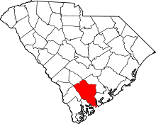
| County | Colleton |
| Area[1] | |
| • Total | 14.465 sq mi (37.46 km2) |
| • Land | 14.465 sq mi (37.46 km2) |
| • Water | 0 sq mi (0 km2) |
| Elevation | 23 ft (7 m) |
| Population (2010)[2] | |
| • Total | 478 |
| • Density | 33/sq mi (13/km2) |
| Time zone | Eastern (EST) (UTC-5) |
| • Summer (DST) | EDT (UTC-4) |
| ZIP code | 29446 |
| Area code(s) | 843 |
| GNIS feature ID | 1246146[3] |
Jacksonboro is an unincorporated community and census-designated place located in southeastern Colleton County, South Carolina, United States, along the Edisto River. Jacksonboro serves as a primary junction along U.S. Highway 17 and is roughly halfway between Charleston and Beaufort.[3] Its population was 478 as of the 2010 census.[2]
The Pon Pon Chapel was listed in the National Register of Historic Places in 1972.[4]
Notes
- ↑ "US Gazetteer files: 2010, 2000, and 1990". United States Census Bureau. 2011-02-12. Retrieved 2011-04-23.
- ↑ 2.0 2.1 "American FactFinder". United States Census Bureau. Retrieved 2011-05-14.
- ↑ 3.0 3.1 "Jacksonboro, South Carolina". Geographic Names Information System. United States Geological Survey.
- ↑ "National Register Information System". National Register of Historic Places. National Park Service. 2010-07-09.
| |||||||||||||||||||||||||
| ||||||||||||||||||||||||||||||||
