Jacaltenango
| Jacaltenango | |
|---|---|
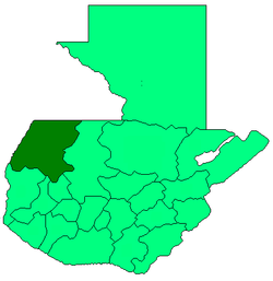
 Jacaltenango Location in Guatemala | |
| Coordinates: 15°40′N 91°44′W / 15.667°N 91.733°W | |
| Country |
|
| Department |
|
| Municipality | Jacaltenango |
| Population (Census 2002) | |
| • City | 34,397 |
| • Urban | 23,464 |
| • Ethnicities | Jakaltek, Ladino |
| • Religions | Roman Catholicism, Evangelicalism, Maya |
| Climate | Cwb |
Jacaltenango is a town situated in the Western Highlands of Guatemala. It is located in a valley surrounded by the Sierra Madre Mountains. Jacaltenango serves as the municipal seat for the surrounding municipality of the same name. In 2002, its urban population was about 23,500[1] but the town's population is projected to have grown to over 40,000.[2]
Its economy is based mainly on agricultural products, especially coffee. Jacaltenango exports about 95% of its agricultural production. Jacaltenango has six schools: three elementary and three high schools, which include middle school.
-
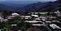
View of Jacaltenango from the Hermita San Sebastian (1986).
-

View of Jacaltenango and San Marcos beyond.
References
- ↑ "2002 census". Instituto Nacional de Estadísticas. Retrieved 2008-05-11.
- ↑ World Gazetter Jacaltenango Retrieved on July 27, 2007
Coordinates: 15°40′N 91°44′W / 15.667°N 91.733°W