Iwade
| Iwade | |
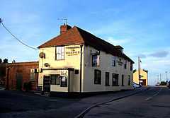 The Woolpack Inn, Iwade |
|
 Iwade |
|
| District | Swale |
|---|---|
| Shire county | Kent |
| Region | South East |
| Country | England |
| Sovereign state | United Kingdom |
| Post town | SITTINGBOURNE |
| Postcode district | ME9 |
| Dialling code | 01795 |
| EU Parliament | South East England |
Coordinates: 51°22′34″N 0°43′41″E / 51.376°N 0.728°E
Iwade is a village 2 miles (3.2 km) north of the town of Sittingbourne in the English county of Kent. It lies on the old route of the A249 road to the Isle of Sheppey but was bypassed when the road was upgraded to a dual carriageway in 2006. Iwade is the nearest settlement to Swale railway station.
According to Edward Hasted, in 1798, the manor of Warde, was within the hundred of Teynham. It had sixteen houses, and about 60 or 70 inhabitants.[1]
Although small, Iwade has a primary school, nursery, health centre,[2] village hall, public house (The Woolpack)[3] and post office and village shop. The village church is dedicated to All Saints and is a Grade I listed building[4] It is within the diocese of Canterbury, and deanery of Sittingborne.[1]
The village also features the Sittingbourne Speedway track, which offers speedway training facilities for riders all over the country. It was the base of the speedway team Sittingbourne Crusaders who raced in the Conference League sporadically from 1995 until 2008.
In 2014, during the development of new homes, a henge was discovered.
References
- ↑ 1.0 1.1 Hasted, Edward (1799). "Parishes". The History and Topographical Survey of the County of Kent (Institute of Historical Research) 6: 203–206. Retrieved 27 February 2014.
- ↑ http://www.mhiwade.co.uk/
- ↑ The Woolpack
- ↑ "Church of All Saints, Iwade". www.britishlistedbuildings.co.uk. Retrieved 27 February 2014.
External links
| Wikimedia Commons has media related to Iwade. |