Iveagh Upper, Lower Half
| Iveagh Upper, Lower Half Uíbh Eachach Uachtarach, An Leath Íochtair[1](Irish) | |
|---|---|
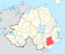
 Location of Iveagh Upper, Lower Half, County Down, Northern Ireland. | |
| Sovereign state | United Kingdom |
| Country | Northern Ireland |
| County | Down |
Iveagh Upper, Lower Half is the name of a barony in County Down, Northern Ireland.[2] It was created by 1851 with the division of the barony of Iveagh Upper into two.[3] It lies in the centre of the county, and is bordered by six other baronies: Iveagh Upper, Upper Half and Lordship of Newry to the west; Mourne to the south; Kinelarty and Lecale Upper to the east; and Iveagh Lower, Upper Half to the north.[2]
List of settlements
Below is a list of the villages and population centres in Iveagh Upper, Lower Half:[1]
Towns
Villages
Population centres
- Ardaragh
- Ballyroney
- Ballyward
- Cabragh
- Deehommed
- Drumlee
- Katesbridge
- Leitrim
- May's Corner
List of civil parishes
Below is a list of civil parishes in Iveagh Upper, Lower Half:[1][4]
- Clonduff
- Dromara (split with barony of Iveagh Lower, Lower Half)
- Drumballyroney
- Drumgooland
- Garvaghy (split with barony of Iveagh Lower, Lower Half)
- Kilcoo
- Maghera
- Kilmegan (split with the baronies of Kinelarty and Lecale Upper)
- Newry (split with the Lordship of Newry)
References
<div class="reflist columns references-column-width" style="-moz-column-width: [5] [2] [1] [3] [4]; -webkit-column-width: [5] [2] [1] [3] [4]; column-width: [5] [2] [1] [3] [4]; list-style-type: decimal;">
- ↑ 1.0 1.1 1.2 1.3 1.4 1.5 Logainm - Iveagh Upper, Lower Half
- ↑ 2.0 2.1 2.2 2.3 2.4 PRONI Baronies of Northern Ireland
- ↑ 3.0 3.1 3.2 3.3 Database of Irish Historical Statistics - Literacy Notes
- ↑ 4.0 4.1 4.2 4.3 PRONI Civil Parishes of County Down
- ↑ 5.0 5.1 5.2 Ulster Place Names - Down Council Area, page 44.