Itayanagi, Aomori
| Itayanagi 板柳町 | |||
|---|---|---|---|
| Town | |||
|
Itayanagi Station | |||
| |||
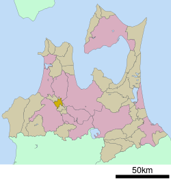 Location of Itayanagi in Aomori Prefecture | |||
 Itayanagi
| |||
| Coordinates: 40°41′N 140°27′E / 40.683°N 140.450°ECoordinates: 40°41′N 140°27′E / 40.683°N 140.450°E | |||
| Country | Japan | ||
| Region | Tōhoku | ||
| Prefecture | Aomori Prefecture | ||
| District | Kitatsugaru | ||
| Area | |||
| • Total | 41.81 km2 (16.14 sq mi) | ||
| Population (April 2012) | |||
| • Total | 14,911 | ||
| • Density | 357/km2 (920/sq mi) | ||
| Time zone | Japan Standard Time (UTC+9) | ||
| - Tree | Maple | ||
| - Flower | Platycodon grandiflorus | ||
| Phone number | 0172-73-2111 | ||
| Address |
239-3 Doi, Itayanagi-machi Kitatsugraru-gun, Aomoir-ken 038-3692 | ||
| Website | Itayanagi Town | ||


Itayanagi (板柳町 Itayanagi-machi) is a town located in Kitatsugaru District of northeastern Aomori Prefecture in the Tōhoku region of Japan. As of April 2012, the town had an estimated population of 14,911 and a population density of 357 persons per km². Its total area was 41.81 km².
Geography
Itayanagi is located at the base of Tsugaru Peninsula. The town has a cold maritime climate characterized by cool short summers and long cold winters with heavy snowfall.
Neighbouring municipalities
History
The area around Itayanagi was controlled by the Nambu clan of Morioka Domain during the Edo period, and was the location of a daikansho. After the Meiji Restoration, on March 27, 1895 it was formed into a village. It was elevated to town status on April 1, 1920. On March 10, 1955, it annexed the neighboring villages of Hataoka, Koami, and Arakawa.
Economy
The economy of Itayanagi is heavily dependent on horticulture, especially for apples, with rice as a secondary crop.
Transportation
Railway
Highway
Sister city
 Yakima, Washington, United States of America
 Changping District, Beijing, China
Noted people from Itayanagi
- Chū Kudō – Manchukuo politician
- Hayateumi Hidehito - sumo wrestler
- Takamisakari Seiken – sumo wrestler
- Kayoko Fukushi – track and field athlete
- Mami Matsuyama – pop idol singer
- Norio Nagayama – mass murder and novelist
External links
| Wikivoyage has a travel guide for Itayanagi. |
- (Japanese) Itayanagi official website
| Wikimedia Commons has media related to Itayanagi, Aomori. |
| ||||||||||||||||||||||||||||||||||||||||