Itatiaia National Park


Itatiaia National Park (Parque Nacional do Itatiaia), established in 1937, is the oldest national park in Brazil.[1] It is located on the border between Rio de Janeiro and Minas Gerais states, between 22º16’ - 22º28’ S and 44º34’ - 44º42’ W.
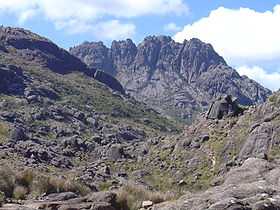
The park is part of the Mantiqueira mountain range, and home to Brazil's third highest mountain, Pico das Agulhas Negras, which stands at 2,878 meters. This peak is visible to the northwest of Resende when driving between São Paulo and Rio de Janeiro on the Via Dutra highway, which is the easiest route to get there.
The park attracts bird watchers from all over the world with its 350 species of birds. Other attractions include hiking and rock climbing.
The park is surrounded by the Mantiqueira Mountain Environmental Protection Area which provides an ecological buffer zone for the park.
The park is divided in two areas: high and low. The high area is accessible through an entrance about 35 km from the main entrance and gives access to the Pico das Agulhas Negras and Prateleiras complex.
The low area of the park is much closer to the city of Itatiaia and has many waterfalls, such as Véu da Noiva with 45 meters. The low area has also a Natural History museum.
Itatiaia means "many-pointed rock" in the Tupi language.
See also
References
- ↑ Ariane Janér: The National Parks of Brazil, EcoBrasil - Brazilian Ecotourism Association
Further reading
- Jorge Pádua, Maria Tereza e Coimbra Filho, Adelmar F. Os Parques Nacionais do Brasil. Instituto de Cooperação Iberoamericana. Madrid. José Olympio Editora, 1989. ISBN 84-85389-19-0, pág. 122 a 129
- Corrêa, Marcos Sá "Itatiaia - O Caminho das Pedras" São Paulo. Metalivros, 2003. ISBN 85-85371-50-1, 240 pág.
- Leite, Helton Perillo Ferreira - "Planalto do Itatiaia - Região das Agulhas Negras", Rio de Janeiro. Montanhar / Publit, 2007. Edição parcialmente trilíngue. ISBN 978-85-7773-076-6, 232 páginas.
External links
![]() Media related to Itatiaia National Park at Wikimedia Commons
Media related to Itatiaia National Park at Wikimedia Commons