Ismenius Lacus quadrangle
|
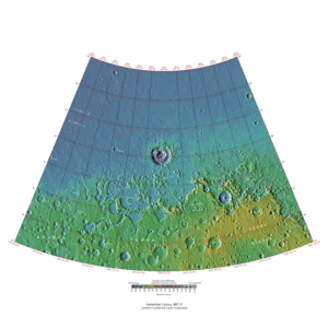
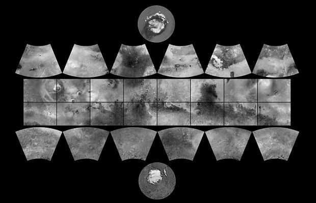
Map of Ismenius Lacus quadrangle from Mars Orbiter Laser Altimeter (MOLA) data. The highest elevations are red and the lowest are blue. | |
| Coordinates | 47°30′N 330°00′W / 47.5°N 330°WCoordinates: 47°30′N 330°00′W / 47.5°N 330°W |
|---|---|

The Ismenius Lacus quadrangle is one of a series of 30 quadrangle maps of Mars used by the United States Geological Survey (USGS) Astrogeology Research Program. The quadrangle is located in the northwestern portion of Mars’ eastern hemisphere and covers 0° to 60° east longitude (300° to 360° west longitude) and 30° to 65° north latitude. The quadrangle uses a Lambert conformal conic projection at a nominal scale of 1:5,000,000 (1:5M). The Ismenius Lacus quadrangle is also referred to as MC-5 (Mars Chart-5).[1] The southern and northern borders of the Ismenius Lacus quadrangle are approximately 3,065 km (1,905 mi) and 1,500 km (930 mi) wide, respectively. The north to south distance is about 2,050 km (1,270 mi) (slightly less than the length of Greenland).[2] The quadrangle covers an approximate area of 4.9 million square km, or a little over 3% of Mars’ surface area.[3] The Ismenius Lacus quadrangle contains parts of Acidalia Planitia, Arabia Terra, Vastitas Borealis, and Terra Sabaea.[4]
The Ismenius Lacus quadrangle contains Deuteronilus Mensae and Protonilus Mensae, two places that are of special interest to scientists. They contain evidence of present and past glacial activity. They also have a landscape unique to Mars, called Fretted terrain. The largest crater in the area is Lyot Crater which contains channels probably carved by liquid water.[5] [6]
Origin of Name
Ismenius Lacus is the name of a telescopic albedo feature located at 40° N and 30° E on Mars. The term is Latin for Ismenian Lake. Ismenia is the poetic name for Thebes, a city in Greece. The name was approved by the International Astronomical Union (IAU) in 1958.[7]
Physiography and Geology
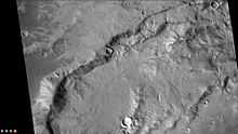
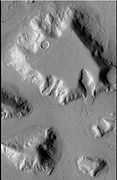
In eastern Ismenius Lacus, lies Mamers Valles, a giant outflow channel.
-

Wide view of Mamers Vallis with cliffs, as seen by HiRISE.
-

Smooth cliff of Mamers Valles. Note the lack of boulders. Much of the surface may have just been blown in or dropped from the sky (as dirty frost). Image from HiRISE.
-

Layered deposit in Mamers Valles, as seen by HiRISE.
The channel shown below goes quite a long distance and has branches. It ends in a depression that may have been a lake at one time. The first picture is a wide angle, taken with CTX; while the second is a close up taken with HiRISE.[8]
-

Channels in Arabia, as seen by CTX This channel winds along for a good distance and has branches. It ends in a depression that may have been a lake at one time.
-

Channel in Arabia, as seen by HiRISE under HiWish program. This is an enlargement of the previous image that was taken with CTX to give a wide view.
-

Channel within larger channel, as seen by HiRISE under HiWish program The existence of the smaller channel suggests water went through the region at least two times in the past.
-

Close-up of channel within larger channel, as seen by HiRISE under HiWish program The existence of the smaller channel suggests water went through the region at least two times in the past. The black box represents the size of a football field. Some parts of the surface would be difficult to walk on with the many small hills and depressions.
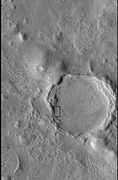
Lyot Crater
The northern plains are generally flat and smooth with few craters. However, a few large craters do stand out. The giant impact crater, Lyot, is easy to see in the northern part of Ismenius Lacus.[9] Lyot Crater is the deepest point in Mars's northern hemisphere.[10] One image below of Lyot Crater Dunes shows a variety of interesting forms: dark dunes, light-toned deposits, and Dust Devil Tracks. Dust devils, which resemble miniature tornados create the tracks by removing a thin, but bright deposit of dust to reveal the darker underlying surface. Light-toned deposits are widely believed to contain minerals formed in water. Research, published in June 2010, described evidence for liquid water in Lyot crater in the past.[5] [6]
-

Lyot Crater Gullies, as seen by HiRISE.
-

Lyot Crater Channel, as seen by CTX. Water-carved channels have been spotted in Lyot Crater; the curved line may be one. Click on image for a better view.
-

Channels in Lyot Crater as seen by HiRISE.
-

Lyot Crater Dunes, as seen by HiRISE. Click on image to see light-toned deposits and dust devil tracks.
Other Craters
Impact craters generally have a rim with ejecta around them; in contrast volcanic craters usually do not have a rim or ejecta deposits. As craters get larger (greater than 10 km in diameter), they usually have a central peak.[11] The peak is caused by a rebound of the crater floor following the impact.[12] Sometimes craters will display layers in their walls. Since the collision that produces a crater is like a powerful explosion, rocks from deep underground are tossed unto the surface. Hence, craters are useful for showing us what lies deep under the surface.
-

Valleys on the Ejecta Blanket from Cerulli Crater, as seen by HiRISE.
-

Cerulli Crater Channels, as seen by THEMIS. Channels are on the inner north rim of the crater.
-

Cerulli Crater, as seen by HiRISE.
-

Semeykin Crater Drainage, as seen by THEMIS. Click on image to see details of beautiful drainage system.
-

Western side of Focas Crater, as seen by CTX camera (on Mars Reconnaissance Orbiter).
-
Small channels in Focus Crater, as seen by CTX camera (on Mars Reconnaissance Orbiter). Note this is an enlargement of the previous CTX image of Focas Crater.
-

Eastern side of Quenisset Crater, as seen by CTX camera (on Mars Reconnaissance Orbiter).
-

Northeast rim of Quenisset Crater, as seen by CTX camera (on Mars Reconnaissance Orbiter). Note: this is an enlargement of the previous image of Quenisset Crater. Arrows indicate old glaciers.
-

West side of Sinton Crater, as seen by CTX camera (on Mars Reconnaissance Orbiter).
-

Channels just to south of Sinton Crater, as seen by CTX camera (on Mars Reconnaissance Orbiter). These were created when the impact occurred in ice-rich ground. Note: this is an enlargement of the previous image of west side of Sinton.
-

Old glacier just to north of Sinton Crater, as seen by CTX camera (on Mars Reconnaissance Orbiter). This is one of many glaciers in the region. Note: this is an enlargement of a previous image of west side of Sinton.
-

MOLA map showing Rudaux Crater, and other nearby craters. Colors show elevations.
-

West rim of Rudaux Crater, as seen by CTX camera (on Mars Reconnaissance Orbiter).
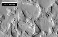
Fretted Terrain
The Ismenius Lacus quadrangle contains several interesting features such as Fretted terrain, parts of which are found in Deuteronilus Mensae and Protonilus Mensae. Fretted terrain contains smooth, flat lowlands along with steep cliffs. The scarps or cliffs are usually 1 to 2 km high. Channels in the area have wide, flat floors and steep walls. Many buttes and mesas are present.[13] In fretted terrain the land seems to transition from narrow straight valleys to isolated mesas.[14] Most of the mesas are surrounded by forms that have been called a variety of names: circum-mesa aprons, debris aprons, rock glaciers, and Lobate Debris Aprons.[15] At first they appeared to resemble rock glaciers on Earth. But scientists could not be sure. Even after the Mars Global Surveyor (MGS) Mars Orbiter Camera (MOC) took a variety of pictures of fretted terrain, experts could not tell for sure if material was moving or flowing as it would in an ice-rich deposit (glacier). Eventually, proof of their true nature was discovered by radar studies with the Mars Reconnaissance Orbiter showed that they contain pure water ice covered with a thin layer of rocks that insulated the ice.[16][17]
-

Fretted terrain of Ismenius Lacus showing flat floored valleys and cliffs. Photo taken with Mars Orbiter Camera (MOC)on the Mars Global Surveyor, under the MOC Public Targeting Program.
-

Enlargement of the photo on the left showing cliff. Photo taken with high resolution camera of Mars Global Surveyor (MGS), under the MOC Public Targeting Program.
-

Wide view of mesa with CTX showing Cliff face and location of Lobate Debris Apron (LDA) Location is Ismenius Lacus quadrangle.
-

Enlargement of previous CTX image of mesa This image shows the cliff face and detail in the LDA. Image taken with HiRISE under HiWish program. Location is Ismenius Lacus quadrangle.
-

Wide CTX view showing mesa and buttes with Lobate debris aprons and lineated valley fill around them. Location is Ismenius Lacus quadrangle.
-

Close-up of Lineated Valley Fill (LVF), as seen by HiRISE under HiWish program Note: this is an enlargement of the previous CTX image.
Glaciers
Glaciers formed much of the observable surface in large areas of Mars. Much of the area in high latitudes, especially the Ismenius Lacus quadrangle, is believed to still contain enormous amounts of water ice.[12][16][18] In March 2010, scientists released the results of a radar study of an area called Deuteronilus Mensae that found widespread evidence of ice lying beneath a few meters of rock debris.[19] The ice was probably deposited as snowfall during an earlier climate when the poles were tilted more.[20] It would be difficult to take a hike on the fretted terrain where glaciers are common because the surface is folded, pitted, and often covered with linear striations.[21] The striations show the direction of movement. Much of this rough texture is due to sublimation of buried ice. The ice goes directly into a gas (this process is called sublimation) and leaves behind an empty space. Overlying material then collapses into the void.[22] Glaciers are not pure ice; they contain dirt and rocks. At times, they will dump their load of materials into ridges. Such ridges are called moraines. Some places on Mars have groups of ridges that are twisted around; this may have been due to more movement after the ridges were put into place. Sometimes chunks of ice fall from the glacier and get buried in the land surface. When they melt and more or less round hole remains.[23] On Earth we call these features kettles or kettle holes. Mendon Ponds Park in upstate NY has preserved several of these kettles. The picture from HiRISE below shows possible kettles in Moreux Crater.
-

Moreux Crater moraines and kettle holes, as seen by HIRISE.
-

Clanis and Hypsas Valles, as seen by HiRISE. Ridges are probably due to glacial flow. So water ice is under a thin layer of rocks.
-

Elephant Foot Glacier in the Earth's Arctic, as seen by Landsat 8. This picture shows several glaciers that have the same shape as many features on Mars that are believed to also be glaciers.
-

Tributary Glacier, as seen by HiRISE.
-

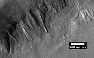
Coloe Fossae Lineated Valley Fill, as seen by HiRISE. Scale bar is 500 meters long.
-
Place where a lobate debris apron begins. Note stripes which indicates movement. Image located in Ismenius Lacus quadrangle. Lobate Debris Aprons have been shown to contain almost pure water ice covered over with a layer of rocky debris.
-

Probable glacier as seen by HiRISE under HiWish program. Radar studies have found that it is made up of almost completely pure ice. It appears to be moving from the high ground (a mesa) on the right.
-
Mesa in Ismenius Lacus quadrangle, as seen by CTX. Mesa has several glaciers eroding it. One of the glaciers is seen in greater detail in the next two images from HiRISE.
-

Glacier as seen by HiRISE under the HiWish program. Area in rectangle is enlarged in the next photo. Zone of accumulation of snow at the top. Glacier is moving down valley, then spreading out on plain. Evidence for flow comes from the many lines on surface. Location is in Protonilus Mensae in Ismenius Lacus quadrangle.
-

Enlargement of area in rectangle of the previous image. On Earth the ridge would be called the terminal moraine of an alpine glacier. Picture taken with HiRISE under the HiWish program.
-

CTX context image showing location of next HiRISE image (letter A box).
-

Possible moraine on the end of a past glacier on a mound in Deuteronilus Mensae, as seen by HiRISE, under the HiWish program. Location of this image is the box labeled A in previous image.
-

Remains of glaciers, as seen by HiRISE under the HiWish program.
-

Remains of a glacier after ice has disappeared, as seen by HiRISE under HiWish program.
-

Arrows point to drumlin-like shapes that were probably formed under a glacier, as seen by HiRISE, under HiWish program.
-

Lobate Debris Aprons (LDA's) around a mesa, as seen by CTX Mesa and LDA's are labeled so one can see their relationship. Radar studies have determined that LDA's contain ice; therefore these can be important for future colonists of Mars. Location is Ismenius Lacus quadrangle.
-

Close up of Lobate debris apron (LDA), as seen by HiRISE under HiWish program
-

Wide CTX view of mesa showing Lobate Debris Apron (LDA) and Lineated Valley Fill. Both are believed to be debris covered glaciers. Location is Ismenius Lacus quadrangle.
-

Close-up of Lobate Debris Apron from the previous CTX image of a mesa. Image shows open-cell brain terrain and closed-cell brain terrain which is more common. Open-cell brain terrain is thought to hold a core of ice. Image is from HiRISE under HiWish program.
Climate change caused ice-rich features
Many features on Mars, especially ones found in the Ismenius Lacus quadrangle, are believed to contain large amounts of ice. The most popular model for the origin of the ice is climate change from large changes in the tilt of the planet's rotational axis. At times the tilt has even been greater than 80 degrees[24][25] Large changes in the tilt explains many ice-rich features on Mars.
Studies have shown that when the tilt of Mars reaches 45 degrees from its current 25 degrees, ice is no longer stable at the poles.[26] Furthermore, at this high tilt, stores of solid carbon dioxide (dry ice) sublimate, thereby increasing the atmospheric pressure. This increased pressure allows more dust to be held in the atmosphere. Moisture in the atmosphere will fall as snow or as ice frozen onto dust grains. Calculations suggest this material will concentrate in the mid-latitudes.[27][28] General circulation models of the Martian atmosphere predict accumulations of ice-rich dust in the same areas where ice-rich features are found.[29] When the tilt begins to return to lower values, the ice sublimates (turns directly to a gas) and leaves behind a lag of dust.[30][30][31] The lag deposit caps the underlying material so with each cycle of high tilt levels, some ice-rich mantle remains behind.[32] Note, that the smooth surface mantle layer probably represents only relative recent material.
Deltas
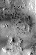
Researchers have found a number of examples of deltas that formed in Martian lakes. Deltas are major signs that Mars once had a lot of water because deltas usually require deep water over a long period of time to form. In addition, the water level needs to be stable to keep sediment from washing away. Deltas have been found over a wide geographical range. Below, is a pictures of a one in the Ismenius Lacus quadrangle.[33]
-

Delta in Ismenius Lacus quadrangle, as seen by THEMIS.
Pits and Cracks
Some places in the Ismenius Lacus quadrangle display large numbers of cracks and pits. It is widely believed that these are the result of ground ice sublimating (changing directly from a solid to a gas). After the ice leaves, the ground collapses in the shape of pits and cracks. The pits may come first. When enough pits form, they unite to form cracks.[34]
-

Coloe Fossae Pits, as seen by HiRISE. Pits are believed to result from escaping water.
-
CTX Image in Protonilus Mensae, showing location of next image.
-

Pits in Protonilus Mensae, as seen by HiRISE, under the HiWish program.
-

Close-up of pits, as seen by HiRISE under the HiWish program. Resolution is about 30 cm, so one could see a kitchen table if it were in the picture.
-

Close-up of patterned ground in a crater deposit, as seen by HiRISE under the HiWish program. Resolution is about 30 cm, so one could see a kitchen table if it were in the picture.
-

Close-up of pits forming along the edges of polygons in patterned ground, as seen by HiRISE under the HiWish program. Resolution is about 30 cm, so one could see a kitchen table if it were in the picture.
Other Images from Ismenius Lacus quadrangle
-

Map of Ismenius Lacus quadrangle which is located just north of Arabia, a large bright area of Mars. It contains large amounts of ice in glaciers that surround hills.
-
CTX Context image of Deuteronilus Mensae showing location of next two images.
-
Eroded terrain in Deuteronilus Mensae, as seen by HiRISE, under the HiWish program.
-
Another view of eroded terrain in Deuteronilus Mensae, as seen by HiRISE, under the HiWish program.
-
CTX context image showing location of next HiRISE image (letter B box).
-

Complex surface around mound in Deuteronilus Mensae, as seen by HiRISE, under the HiWish program. Location of this image is in the black box labeled B in the previous image.
-

End of a glacier, as seen by HiRISE under HiWish program. Surface to the right of the end moraine exhibits patterned ground which is common where ground water has frozen.
-

Surface forms in Ismenius Lacus, as seen by HiRISE under HiWish program.
-

Hollowed out terrain in Deuteronilus Mensae, as seen by HiRISE under HiWish program.
-
Field of pits, as seen by HiRISE under HiWish program.
-

Large group of concentric cracks, as seen by HiRISE, under HiWish program.
-

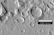
Ring mold craters on floor of a crater, as seen by HiRISE under HiWish program
-

Ring mold craters of various sizes on floor of a crater, as seen by HiRISE under HiWish program
See also
- Climate of Mars
- Deuteronilus Mensae
- Fretted terrain
- Glacier
- Glaciers on Mars
- List of quadrangles on Mars
- Lobate Debris Apron
- Lyot Crater
- Impact crater
- Protonilus Mensae
- Vallis
- Water on Mars
| Wikimedia Commons has media related to Ismenius Lacus quadrangle. |
References
- ↑ Davies, M.E.; Batson, R.M.; Wu, S.S.C. “Geodesy and Cartography” in Kieffer, H.H.; Jakosky, B.M.; Snyder, C.W.; Matthews, M.S., Eds. Mars. University of Arizona Press: Tucson, 1992.
- ↑ Distances calculated using NASA World Wind measuring tool. http://worldwind.arc.nasa.gov/.
- ↑ Approximated by integrating latitudinal strips with area of R^2 (L1-L2)(cos(A)dA) from 30° to 65° latitude; where R = 3889 km, A is latitude, and angles expressed in radians. See: http://stackoverflow.com/questions/1340223/calculating-area-enclosed-by-arbitrary-polygon-on-earths-surface.
- ↑ http://planetarynames.wr.usgs.gov/SearchResults?target=MARS&featureType=Terra,%20terrae
- ↑ 5.0 5.1 J. Carter, F. Poulet, J.-P. Bibring, and S. Murchie. Detection of Hydrated Silicates in Crustal Outcrops in the Northern Plains of Mars. Science, 2010; 328 (5986): 1682-1686
- ↑ 6.0 6.1 http://www.jpl.nasa.gov/news.cfm?release=2010-209
- ↑ USGS Gazetteer of Planetary Nomenclature. Mars. http://planetarynames.wr.usgs.gov/.
- ↑ http://www.uahirise.org/ESP_039997_2170
- ↑ U.S. department of the Interior U.S. Geological Survey, Topographic Map of the Eastern Region of Mars M 15M 0/270 2AT, 1991
- ↑ http://space.com/scienceastronomy/090514--mars-rivers.html
- ↑ http://www.lpi.usra.edu/publications/slidesets/stones/
- ↑ 12.0 12.1 Hugh H. Kieffer (1992). Mars. University of Arizona Press. ISBN 978-0-8165-1257-7. Retrieved 7 March 2011.
- ↑ ISBN 0-8165-1247-4
- ↑ Sharp, R. 1973. Mars Fretted and chaotic terrains. J. Geophys. Res: 78. 4073-4083
- ↑ http://www.lpi.usra.edu/meetings/lpsc2000/pdf/1053.pdf
- ↑ 16.0 16.1 Plaut, J. et al. 2008. Radar Evidence for Ice in Lobate Debris Aprons in the Mid-Northern Latitudes of Mars. Lunar and Planetary Science XXXIX. 2290.pdf
- ↑ Plaut, J., A. Safaeinili,, J. Holt, R. Phillips, J. Head, J., R. Seu, N. Putzig, A. Frigeri. 2009. Radar evidence for ice in lobate debris aprons in the midnorthern latitudes of Mars. Geophys. Res. Lett. 36. doi:10.1029/2008GL036379.
- ↑ http://www.esa.int/SPECIALS/Mars_Express/SEMBS5V681F_0.html
- ↑ http://news.discovery.com/space/mars-ice-sheet-climate.html
- ↑ Madeleine, J. et al. 2007. Exploring the northern mid-latitude glaciation with a general circulation model. In: Seventh International Conference on Mars. Abstract 3096.
- ↑ http://www.uahirise.org/ESP_018857_2225
- ↑ http://hirise.lpl.arizona.edu/PSP_009719_2230
- ↑ http://hirise.lpl.arizona.edu/PSP_006278_2225
- ↑ Touma J. and J. Wisdom. 1993. The Chaotic Obliquity of Mars. Science 259, 1294-1297.
- ↑ Laskar, J., A. Correia, M. Gastineau, F. Joutel, B. Levrard, and P. Robutel. 2004. Long term evolution and chaotic diffusion of the insolation quantities of Mars. Icarus 170, 343-364.
- ↑ Levy, J., J. Head, D. Marchant, D. Kowalewski. 2008. Identification of sublimation-type thermal contraction crack polygons at the proposed NASA Phoenix landing site: Implications for substrate properties and climate-driven morphological evolution. Geophys. Res. Lett. 35. doi:10.1029/2007GL032813.
- ↑ Levy, J., J. Head, D. Marchant. 2009a. Thermal contraction crack polygons on Mars: Classification, distribution, and climate implications from HiRISE observations. J. Geophys. Res. 114. doi:10.1029/2008JE003273.
- ↑ Hauber, E., D. Reiss, M. Ulrich, F. Preusker, F. Trauthan, M. Zanetti, H. Hiesinger, R. Jaumann, L. Johansson, A. Johnsson, S. Van Gaselt, M. Olvmo. 2011. Landscape evolution in Martian mid-latitude regions: insights from analogous periglacial landforms in Svalbard. In: Balme, M., A. Bargery, C. Gallagher, S. Guta (eds). Martian Geomorphology. Geological Society, London. Special Publications: 356. 111-131
- ↑ Laskar, J., A. Correia, M. Gastineau, F. Joutel, B. Levrard, and P. Robutel. 2004. Long term evolution and chaotic diffusion of the insolation quantities of Mars. Icarus 170, 343-364.
- ↑ 30.0 30.1 Mellon, M., B. Jakosky. 1995. The distribution and behavior of Martian ground ice during past and present epochs. J. Geophys. Res. 100, 11781–11799.
- ↑ Schorghofer, N., 2007. Dynamics of ice ages on Mars. Nature 449, 192–194.
- ↑ Madeleine, J., F. Forget, J. Head, B. Levrard, F. Montmessin. 2007. Exploring the northern mid-latitude glaciation with a general circulation model. In: Seventh International Conference on Mars. Abstract 3096.
- ↑ Irwin III, R. et al. 2005. An intense terminal epoch of widespread fluvial activity on early Mars: 2. Increased runoff and paleolake development. Journal of Geophysical Research: 10. E12S15
- ↑ "HiRISE | Fretted Terrain Valley Traverse (PSP_009719_2230)". Hirise.lpl.arizona.edu. Retrieved December 19, 2010.
External links

| Quadrangles on Mars | |||||||||||||||||||||||
|---|---|---|---|---|---|---|---|---|---|---|---|---|---|---|---|---|---|---|---|---|---|---|---|
| MC-01 Mare Boreum (features) | |||||||||||||||||||||||
| MC-05 Ismenius Lacus (features) |
MC-06 Casius (features) |
MC-07 Cebrenia (features) |
MC-02 Diacria (features) |
MC-03 Arcadia (features) |
MC-04 Acidalium (features) | ||||||||||||||||||
| MC-12 Arabia (features) |
MC-13 Syrtis Major (features) |
MC-14 Amenthes (features) |
MC-15 Elysium (features) |
MC-08 Amazonis (features) |
MC-09 Tharsis (features) |
MC-10 Lunae Palus (features) |
MC-11 Oxia Palus (features) | ||||||||||||||||
| MC-20 Sinus Sabaeus (features) |
MC-21 Iapygia (features) |
MC-22 Mare Tyrrhenum (features) |
MC-23 Aeolis (features) |
MC-16 Memnonia (features) |
MC-17 Phoenicis Lacus (features) |
MC-18 Coprates (features) |
MC-19 Margaritifer Sinus (features) | ||||||||||||||||
| MC-27 Noachis (features) |
MC-28 Hellas (features) |
MC-29 Eridania (features) |
MC-24 Phaethontis (features) |
MC-25 Thaumasia (features) |
MC-26 Argyre (features) | ||||||||||||||||||
| MC-30 Mare Australe (features) | |||||||||||||||||||||||