Isleworth Ait


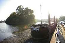
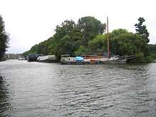
Isleworth Ait, 3.5 hectares (8.6 acres) [1] is a teardrop shaped island in the River Thames in England. It is on the Tideway near Isleworth in the London Borough of Hounslow, and is one of the longest aits. The island lies offshore from Heron's Place, and is opposite a number of commercial buildings.
Isleworth Ait is covered by densely packed trees, and provides a sanctuary for a variety of wildlife. It floods regularly, but is home to more than 57 species of bird life, including the tree-creeper, kingfisher and heron. Two rare species of air-breathing land gastropods also live on the island, the two-lipped door snail Balea biplicata and the German hairy snail Pseudotrichia rubiginosa, as well as several rare species of beetles. This variety of unusual wildlife makes the island one of the London Wildlife Trust's most remarkable reserves. It is a Local Nature Reserve[2][3] and part of The River Thames and tidal tributaries Site of Metropolitan Importance for Nature Conservation.[4][5]
Isleworth Ait was once a centre for the production of osier - a willow which used to be harvested on the island to weave baskets to carry fruit and vegetables grown in Middlesex to the markets in London. There used to be five neighbouring islands, but these have all disappeared over the centuries, some being destroyed by passing boat traffic. The River Crane flows into the Thames to the south of Isleworth Ait and the Duke of Northumberland's River at the northern end.
Thames Water owns the island, which houses the outfall from the nearby Mogden Sewage Treatment Works, returning treated water to the river Thames. The Metropolitan Water Board bought the island from the Duke of Northumberland in the 1930s. The Ait is looked after by a team of volunteers who are part of the Hounslow branch of the London Wildlife Trust.
See also
References
- ↑ "Isleworth Ait". London Wildlife Trust. 2007. Retrieved 21 March 2010.
- ↑ "Isleworth Ait". Local Nature Reserves. Natural England. 5 March 2013. Retrieved 7 January 2014.
- ↑ "Map of Isleworth Ait". Local Nature Reserves. Natural England. Retrieved 7 January 2014.
- ↑ "The River Thames and tidal tributaries". Greenspace Information for Greater London. 2013. Retrieved 7 January 2014.
- ↑ "iGiGL – helping you find London’s parks and wildlife sites (map)". Greenspace Information for Greater London. 2013. Retrieved 7 January 2014.
External links
| Next island upstream | River Thames | Next island downstream |
| Corporation Island | Isleworth Ait | Lot's Ait |
Coordinates: 51°28′08″N 0°19′15″W / 51.4690°N 0.3207°W
| ||||||||||||||||||||||||||||||||||||||||||||||||||||||||||||||||||||||||||||||||||||||||||||||||||||||||||||||||||||||||||
| ||||||||||||||||||||||||||||||||||||||||||||||