Isle La Motte
| Isle La Motte, Vermont | |
|---|---|
| Town | |
|
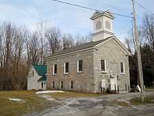
Isle La Motte Methodist Church | |
 Isle La Motte, Vermont | |
| Coordinates: 44°51′59″N 73°19′51″W / 44.86639°N 73.33083°WCoordinates: 44°51′59″N 73°19′51″W / 44.86639°N 73.33083°W | |
| Country | United States |
| State | Vermont |
| County | Grand Isle |
| Area | |
| • Total | 16.7 sq mi (43.1 km2) |
| • Land | 8.0 sq mi (20.6 km2) |
| • Water | 8.7 sq mi (22.5 km2) |
| Elevation | 95 ft (29 m) |
| Population (2010) | |
| • Total | 471 |
| • Density | 61.3/sq mi (23.7/km2) |
| Time zone | Eastern (EST) (UTC-5) |
| • Summer (DST) | EDT (UTC-4) |
| ZIP code | 05463 |
| Area code(s) | 802 |
| FIPS code | 50-35875[1] |
| GNIS feature ID | 1462125[2] |
Isle La Motte is an island and town in Grand Isle County, Vermont, United States. The population was 471 at the 2010 census. The town consists primarily of an island in Lake Champlain. Saint Anne's Shrine is located on the island.
Geography
According to the United States Census Bureau, the town has a total area of 16.7 square miles (43.1 km2), of which 8.0 square miles (20.6 km2) is land and 8.7 square miles (22.5 km2) (52.22%) is water.
The island is known for its quarries of gray or black[3] fossiliferous limestone from the Middle Ordovician Chazy Formation. The limestone consists of a large stromatoporoid patch reef, one of the oldest known metazoan reefs in the Eastern United States.
Demographics
As of the census[1] of 2000, there were 488 people, 202 households, and 143 families residing in the town. The population density was 61.3 people per square mile (23.7/km2). There were 415 housing units at an average density of 52.1 per square mile (20.1/km2). The racial makeup of the town was 97.75% White, 1.23% Native American, 0.20% Asian, and 0.82% from two or more races.
There were 202 households out of which 27.7% had children under the age of 18 living with them, 59.4% were married couples living together, 8.4% had a female householder with no husband present, and 29.2% were non-families. 22.8% of all households were made up of individuals and 7.9% had someone living alone who was 65 years of age or older. The average household size was 2.42 and the average family size was 2.85.
In the town the population was spread out with 25.0% under the age of 18, 4.3% from 18 to 24, 26.2% from 25 to 44, 27.3% from 45 to 64, and 17.2% who were 65 years of age or older. The median age was 42 years. For every 100 females there were 93.7 males. For every 100 females age 18 and over, there were 92.6 males.
The median income for a household in the town was $36,125, and the median income for a family was $41,094. Males had a median income of $28,542 versus $24,000 for females. The per capita income for the town was $20,286. About 7.7% of families and 9.4% of the population were below the poverty line, including 11.5% of those under age 18 and 2.5% of those age 65 or over.
History
| Fort Saint Anne | |
|---|---|
| Isle La Motte, Vermont | |
| Type | Fort |
| Site information | |
| Controlled by | New France; United States |
| Site history | |
| Built | 1666 |
| In use | 1666-1671 |
The French built a fort, which was dedicated to St. Anne, on the island in 1666, the first European settlement in what is now Vermont. Fort St. Anne, the fifth in a line of five forts stretching along the Richelieu River going south, was the one most vulnerable to attack by the Iroquois. The island is named after the leader of this expedition, captain Pierre La Motte.[4][5] These were the first Europeans to spend a winter in Vermont in 1666-7.
Notable events

In 1609, Samuel de Champlain debarked on Isle La Motte July 9.[6][7]
In 1666, Fort Sainte Anne, the first permanent European settlement, was established by the French.[6][7]
In August 1897, President William McKinley addressed the Vermont Fish and Game League[8] at Fisk Farm.[9]
In September 1901, Vice President Theodore Roosevelt visited Isle La Motte to deliver an address to the Vermont Fish and Game League[10] at Fisk Farm[11] when he learned of the attempted assassination of President William McKinley.[12]
In July 1909, Isle La Motte hosted the closing ceremonies of the Lake Champlain tercentenary celebration.[13]
Vermont's first primitive Black Limestone quarries were located in town. The oldest is found behind Fisk Farms. The Black Limestone is a unique sedimentary rock composed of mineral calcite, the fossilized remains of marine creatures, which are especially pronounced within the quarry's 40 feet (12 m) walls. This local limestone is so dark in appearance that it was originally marketed in the 18th and 19th century as Black Marble.
Notes
- ↑ 1.0 1.1 "American FactFinder". United States Census Bureau. Retrieved 2008-01-31.
- ↑ "US Board on Geographic Names". United States Geological Survey. 2007-10-25. Retrieved 2008-01-31.
- ↑ Teresi, Dick (January 2007). "Paleozoic Vermont". p. 26. Smithsonian Magazine. Retrieved 2007-04-15.
- ↑ Hahn, Michael (February 2007). Vintage Cabin Fever: First Vermont Winter for Europeans. Northland Journal.
- ↑ Gannett, Henry (1905). The Origin of Certain Place Names in the United States. Govt. Print. Off. p. 166.
- ↑ 6.0 6.1 "1st Report of the 1909 Champlain Tercentenary Celebration Commission". Hudson River Maritime Museum. 1908-03-23. Retrieved 2007-04-15.
- ↑ 7.0 7.1 Shulevitz, Judith (1990-08-05). "Champlain's Hideaway Islands". New York Times. Retrieved 2007-04-15.
- ↑ [http://pqasb.pqarchiver.com/boston/access/579655042.html? dids=579655042:579655042&FMT=ABS&FMTS=ABS:AI&date=Aug+07%2C+1897&author=&pub=Boston+Daily+Globe&desc=ON+ISLE+LA+MOTTE&pqatl=google "On Isle La Motte"]. Boston Daily Globe. 1897-08-07. p. 3.
- ↑ "Plans for the President's outing". Washington Post. 1897-07-21. p. 3.
- ↑ "Roosevelt Goes To The Bedside". Chicago Daily Tribune. 1901-09-07. p. 2.
- ↑ "Hears the news". Boston Daily Globe. 1901-09-07. p. 6.
- ↑ "Mr. Roosevelt En Route; On Receipt of News the Vice President Leaves for Buffalo". New York Times. 1901-09-07. p. 1.
- ↑ "Celebration Closes on Lake Champlain". New York Times. 1909-07-10. p. 7.
External links

- Isle La Motte Elementary School
- Isle La Motte Preservation Trust
- Isle La Motte Lighthouse
- Saint Anne's Shrine
- Welcome to Isle La Motte, address by Sen. Henry W. Hill, July 9, 1909.
| |||||||||||||||||
