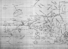
Island of the Jewel


The Island of the Jewel (Arabic: Jazīrat al-Jawhar)[n 1] or Island of Sapphires (Arabic: Jazīrat al-Yāqūt) was a semi-legendary island in medieval Arabic cartography, said to lie in the Sea of Darkness near the equator, forming the eastern limit of the inhabited world. The island does not appear in any surviving manuscript of Ptolemy's Geography nor other Greek geographers. Instead, it is first attested in the Ptolemaic-influenced Book of the Description of the Earth[2][3] compiled by al-Khwārizmī around 833. Ptolemy's map ended at 180° E. of the Fortunate Isles without being able to explain what might lay on the imagined eastern shore of the Indian Ocean or beyond the lands of Sinae and Serica in Asia. Roman missions subsequently reached the Han court via Longbian (Hanoi) and Chinese Muslims traditionally credit the founding of their community to the Companion Saʿd ibn Abi Waqqas as early as the 7th century. Muslim merchants such as Soleiman established sizable expatriate communities; a large-scale massacre is recorded at Yangzhou in 760 amid the An Shi Rebellion against the Tang. These connections showed al-Khwārizmī and other Islamic geographers that the Indian Ocean was not closed as Hipparchus and Ptolemy had held but opened either narrowly or broadly.
The four chorographic maps of the AD 1037 manuscript of al-Khwārizmī—including that of the Island of the Jewel—are the oldest surviving maps from the Islamic world.[4] Al-Khwārizmī gave the Island of the Jewel as the easternmost point of the inhabited world.[5] His gazetteer is divided by categories but altogether he provides coordinates for its coast, three cities, its surrounding chain of mountains, and two summits on the interior.[6] It lies in the Sea of Darkness near the equator,[7] east of his equivalent of Ptolemy's Golden Peninsula (Malaysia) and east of the still larger phantom peninsula—now usually known as the Dragon's Tail[8]—which replaced Ptolemy's unknown eastern shore of the Indian Ocean.[9][10] Its center was given at 173° east of al-Khwārizmī's prime meridian off west Africa and 2° north of the equator.[11]
It subsequently appeared in the world map of the Book of Curiosities—where it is labelled "The Island of the Jewel, and its mountains encircle it like a basket"[5][12] or "like scales"[13][14]—and in other medieval Arabian and Persian texts.
It is now typically identified with one of the Indonesian islands[5][13] or with Taiwan,[5][14] although al-Khwārizmī's description seems to borrow from Ptolemaic and legendary accounts of Taprobane (Sri Lanka).[15]
See also
Notes
Citations
- ↑ Antrim (2012), p. 171.
- ↑ Tibbetts (1987), p. 105.
- ↑ Rapoport (2008), p. 137.
- ↑ Rapoport (2008), pp. 127–128.
- ↑ 5.0 5.1 5.2 5.3 Bodleian (2011).
- ↑ al-Khwārizmī (1037), 7–8, 40–42, 83.
- ↑ Rapoport (2008), p. 133.
- ↑ Siebold (2011).
- ↑ Rapoport (2008), p. 134.
- ↑ Olshin (1994), p. 326.
- ↑ Nallino (1896), p. 41.
- ↑ Rapoport (2008), p. 125.
- ↑ 13.0 13.1 Johns (2003).
- ↑ 14.0 14.1 Rapoport (2004).
- ↑ Tibbetts (1987), p. 106.
References
- Antrim, Zayde (2012), Routes & Realms: The Power of Place in the Early Islamic World, Oxford: Oxford University Press, ISBN 978-0-19-991387-9.
- "The Treasures: An Islamic world map", Treasures of the Bodleian, Oxford: Oxford Digital Library, 2011, retrieved 14 March 2015.
- Daunicht, Hubert (1968), Der Osten nach der Erdkarte al-Ḫuwārizmīs: Beiträge zur historischen Geographie und Geschichte Asiens [The East in the al-Khwārizmī World Map: A Contribution to Historical Geography and Asian History], Vol. I: Rekonstruktion der Karte, Interpretation der Karte: Südasien [Reconstruction & Interpretation of the Map: South Asia], Bonn: Oriental Department of the University of Bonn. (German)
- Johns, Jeremy et al. (2003), "The Book of Curiosities: A Newly Discovered Series of Islamic Maps", Imago Mundi, Vol. 55 (1), London: Routledge, pp. 7–24, doi:10.1080/0308569032000095451, ISSN 0308-5694.
- عبد الله محمد بن موسى الخوارزمی [Abū ‘Abdallāh Muḥammad ibn Mūsā al-Khwārizmī] (1037) [Originally compiled in 833], كتاب صورة الأرض [Kitāb Ṣūrat al-Arḍ, The Book of the Description of the Earth], held by Strasbourg's National & University Library as its Codex 4247. (Arabic)
- Nallino, Carlo Alfonso (1896), "Al-Huwârizmî e il suo rifacimento della Geografia di Tolomeo [Al-Khwārizmī and His Remaking of Ptolemy's Geography]", Atti della Reale Accademia dei Lincei [Proceedings of the Royal Lincean Academy], Series 4, Vol. II, Pt. 1: Memorie [Monographs], Rome: V. Salviucci for the Royal Lincean Academy, pp. 4–53. (Italian)
- Olshin, Benjamin B. (1994), A Sea Discovered: Pre-Columbian Conceptions and Depictions of the Atlantic, Ann Arbor: University of Toronto, ISBN 9780315973237.
- Rapoport, Yossef et al. (December 2004), "Medieval Islamic View of the Cosmos: The Newly Discovered Book of Curiosities", The Cartographic Journal, Vol. 41 (3), London: British Cartographic Society, pp. 253–259, doi:10.1179/000870404X13841, ISSN 0008-7041.
- Rapoport, Yossef et al. (2008), "The Book of Curiosities and a Unique Map of the World", Cartography in Antiquity and the Middle Ages: Fresh Perspectives, New Methods, Leiden: Koninklijke Brill NV, pp. 133–134, ISBN 978-90-04-16663-9.
- Siebold, Jim (2011), "#256: Martellus' World Maps", Cartographic Images, Oviedo: Henry Davis Consulting, retrieved 15 March 2015.
- Tibbetts, Gerald R. (1987), "4 · The Beginnings of a Cartographic Tradition", History of Cartography, Vol. II, Chicago: University of Chicago Press, pp. 90–107.