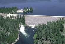
Island Park Dam
| Island Park Dam | |
|---|---|
 | |
 | |
| Location | Fremont County, Idaho, near Island Park, Idaho |
| Coordinates | 44°25′06.92″N 111°23′47.50″W / 44.4185889°N 111.3965278°WCoordinates: 44°25′06.92″N 111°23′47.50″W / 44.4185889°N 111.3965278°W |
| Construction began | 1937 |
| Opening date | 1939 |
| Operator(s) | U.S. Bureau of Reclamation |
| Dam and spillways | |
| Type of dam | Zoned earthfill dam |
| Impounds | Henrys Fork |
| Height | 94 ft (29 m) |
| Length | 9,500 ft (2,900 m) |
| Spillway type | Ungated bathtub |
| Reservoir | |
| Creates | Island Park Reservoir |
| Total capacity | 135,205 acre feet (0.166773 km3) |
| Catchment area | 482 sq mi (1,250 km2)[1] |
Island Park Dam is operated by the U.S. Bureau of Reclamation in Fremont County, Idaho. The dam lies in Targhee National Forest near Island Park. The zoned earthfill dam was built between 1937 and 1939 as part of the Minidoka Project, which provides water to irrigate farmland in Idaho's Snake River Plain.[1]
The dam provides only water storage, impounding 135,000 acre feet (0.167 km3), which is distributed by the Cross Cut Canal to farms in Fremont and Madison counties in Idaho, and Teton County in Wyoming.[1] The Island Park and Grassy Lake reservoirs were built as an alternative to construction of a larger project that would have flooded the Falls River area of Yellowstone National Park.[2][3] Island Park Dam, Idaho holds the record for the eighth coldest temperature recorded in the United States at -60F (minus sixty degrees). Information obtained from state temperature records.
References
- ↑ 1.0 1.1 1.2 "Island Park Dam". Bureau of Reclamation. Retrieved 4 May 2011.
- ↑ Haines, Aubrey L. (1996). The Yellowstone Story: A History of Our First National Park. University Press of Colorado. p. 346. ISBN 0-87081-390-0.
- ↑ Yochim, Michael J. "Conservationists and the Battles to Keep Dams Out of Yellowstone: Hetch Hetchy Overturned". p. 299.
External links
- Island Park Dam at the Bureau of Reclamation