Island Eddy
| Island Eddy Oileán Eide | |
|---|---|
 Island Eddy Location in Ireland | |
| Coordinates: 53°12′N 8°59′W / 53.2°N 8.99°WCoordinates: 53°12′N 8°59′W / 53.2°N 8.99°W | |
| Country | Ireland |
| Province | Connacht |
| County | County Galway |
| Elevation | 8 m (26 ft) |
| Population | uninhabited |
Island Eddy is a small island at the inner, eastern end of Galway Bay.
Orthography
The island is always referred to locally as 'Island Eddy' not 'Eddy Island'. The official Irish Government commission on placenames confirms this usage, giving its Irish and English orthography thus: ‘Oileán Eide / Island Eddy’.[1] It is important not to confuse Island Eddy with Islandeady, a village and parish in Co. Mayo.
Location
Geographical
Island Eddy is situated on the inner reaches of Galway Bay on the west coast of Ireland. The nearest town, as the crow flies, would be Kinvara which sits at the head of a shallow inlet some 7 km to the South-South-East.
Administrative
- Townland Name: Island Eddy[2]
- Civil Parish: Drumacoo[3]
- Barony: Dunkellin[4]
- County: Galway[5]
- Province: Connacht[6]
- Diocese – historical: Kilmacduagh[7]
- Diocese (R. C.) - modern: Galway, Kilmacduagh & Kilfenora[8]
- Poor Law Union: Galway[9]
- Rural District: 10: Galway [10]
- District Electoral Division: 043: Ballynacourty [11]
Physical character
.jpg)
Island Eddy consists of three low islets, inter-linked and flanked by extensive isthmuses and spits composed of shingle. At the South-West end of the island a number of the latter combine to form a large lagoon-like area, and a second series also define another 'lagoon' at the eastern end. These lagoons are known locally as "Malluirs",[12] and are labelled as the North Mallmhuir and the South Mallmhuir, respectively. The islets are probably partially submerged drumlins. A sand spit, called "the cush" locally, extends south-eastwards from the east end of the island allowing access to it from the mainland by foot at certain spring tides.
According to the OS six inches to the mile (1:10,560) scale map the island is '165 Acres, 3 Roods and 24 Perches' (67.14 hectares (165.91 acres)) in extent.[13] Its maximum dimensions are 2.85 kilometres (1.77 mi) long, east to west, and 1.05 kilometres (0.65 mi) wide, north to south. Its maximum elevation is 8 metres (26.25 ft).[14]
History of ownership
1574: Bishop of Kilmacduagh[15]
1641: Dr Robert Gorges (sic)[16]
1667: Dr. Robert Georges[17]
1855: Sir Thomas N. Redington[18]
1981: Martin Keane[19]
Population

| 1821 | 1841 | 1851 | 1861 | 1871 | 1881 | 1891 | 1901 | 1911 | 1926 | 1936 | 1946 | 1951 | 1956 | 1961 | 1966 | 1971 | 1979 | 1981 |
| 72 | 125 | 66 | 61 | 59 | 77 | 65 | 54 | 38 | 35 | 37 | 24 | 16 | 11 | 5 | 4 | 2 | 2 | 0 |
Source: www.cso.ie
History – narratives
- The earliest documentary reference to the island (so far identified) dates from AD 1225. In his Irish Family History;...an historical and genealogical account of the Gaedhals, Richard Cronnelly refers to a raid on 'Hy-Fiachra' by Murtogh O'Brien and the English of Desmond in that year which 'left not a four-footed beast from Island-Eddy to Athenry, or from Tuam to Ectge.'[20]
- In 1574 'ILand Edde' is referred to in a list of Galway castles. It was in the possession of one 'Henry Parell'[21]
- In 1585, during a commission of enquiry by the English authorities into the causes of feuding among the O'Flahertys of Connemara, a number of witnesses attested that the chief O'Flahertie had an 'anuall rent the some of 3s 4d oute of the Islands of Eddy'.[22]
- The OS Name Books, compiled in the late 1830s as part of the Ordnance Survey of Ireland, record the following regarding the island: 'Prop. Thos. Reddington, Esq., M.P., Kilcornan. Agent Mr. O’Flaherty, Inischill. This townland pays £200. Tenants at will. Soil light clay. Produce wheat and oats. There are 24 Tenants appearing very poor. Houses of stone. To the east of the island stands a village called Eddy'.[23]
- A National School was established on the island in November 1877 by the Redington family of Clarinbridge, the island's landlords. According to the application to the National Schools Board for funding of same,[24] the school comprised a single-roomed thatched building '20 feet (6.1 m) long, 14 feet (4.3 m) broad, 10 feet (3.0 m) high' with an earthen floor. The 'walls are plastered' but the building was 'not ceiled'. A total of 34 students were on the rolls in May 1879, of which 20 were male and 14 female. The first teacher was Kate Madden, aged 19 years. Approval for the payment of the teacher's salary, and for books etc., was given in August 1879.
- In 1926-7, the island community was involved in a dispute with local government over the perceived high rate of valuation of the land, resulting in a boycott of rates. Details of this are recorded in The Irish Times [25] and in Dáil Questions [26] Two interesting topographical points emerge from these sources - firstly the statement in the Dáil Questions that the island's valuation 'exceeds the valuation on the best lands in the county'. The second point (in a report by Galway County Council) was that Eddy 'was not a true island' [27]
- Walsh (2004, 120-21) states that it was 'abandoned in 1947',[28] but the census returns (see above) contradict this. In fact, two people still lived there until early December, 1980 [29]
Archaeology – scraps
- The most obvious piece of built heritage is the ruined house-cluster, or "village", at the east end of the island.[30] On the 1st edition of the six-inch (1:10,560) scale OS map (1842), this comprised 41 roofed structures (houses and outbuildings) laid out on a rough E-W axis. However, by the time of the 1:2500 scale OS revision (1915–16) considerable changes are evident in the layout of the buildings. The total number of roofed structures is now 36, and the acreage details on the map indicate that they were divided into 7 parcels.
- The site of the Castle mentioned in 1574 (see above under historical snippets) has been located at the eastern end of the village. All that survives is a large stump of masonry in a boundary wall. When the castle was destroyed is unclear but it was still a landmark in the 1760s when it was included in Murdoch Mackenzie's survey of Galway Bay.[31] It appears to have been reduced to a stump by the time the Ordnance surveyors arrived on the island in the late 1830s; they fail to show it on the OS six inches to the mile (1:10,560) map.[32]
- There is also a Children's Burial Ground on the southern limits of the village. It contains one inscribed gravestone, erected in memory of 'Eliza Murphy Who died 8 April AD 1827 aged 17 Months'. This is the subject of a paper in the 2010 issue of the Journal of the Galway Archaeological & Historical Society (JGAHS).[33]
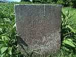 Headstone of Eliza Murphy, dated 1827.
 - An impressive series of boat Nausts have been identified in the North Mallmhuir. A toal of 15 definite and one possible nausts are ranged along 115m of shoreline on the South shore of this long narrow inlet. Associated with them are four jetties, numerous mooring posts and a series of ballast dumps. Known locally as 'cloches', they provided safe moorings for the island's fleet of punts, púcáns and bad mórs. A preliminary survey of these was completed in Spring 2010, details of which have been published in Archaeology Ireland. [34] This is being supplemented by a detailed survey, the results of which will appear in due course.
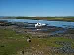 View from SE of Nausts no. 6-8 on North Mallmhuir
 - A series of numbered seaweed mearing stones exist on the intertidal zone of the South Malluir. Six have been identified in situ to date (September 2011). Working from West to East they are numbered: 23, 22, 21, 9, 10 and 11. A further three examples, all displaced, have been identified during in 2010 and 2011 by Brendan MacMahon, John Roden/Moya Cannon, and Micheline Sheehy-Skeffington/Nick Scott. These bear the numbers 5, 16 and 20, respectively. All the examples consist of long, roughly-dressed rectangular blocks of limestone. The numbers, most finely cut, are placed towards the end of one of the broad faces.[35]
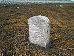 Seaweed Mearing Stone bearing the number 22
 - There is also placename evidence ('cathair') suggesting the former presence of an enclosure of some kind in the central portion of the island.
Arts – music, poetry
- There is a celtic/folk/acoustic music group called Island Eddy based in Kinvara, Co Galway, who took their name from the island.[36]
- Moya Cannon's new collection of poetry, Hands, contains two finely wrought poems relating to Island Eddy - 'Nausts' and 'Eliza Murphy'.[37] Both poems are grounded in the physical particularities of two of the island's most striking monuments, the boat Nausts on the shore of the North Mallmhuir and the Children's Burial Ground on the southern fringes of the village (See Archaeology section, above, for details).
Geology – fragments
- According to the Geological Survey of Ireland, the island's bedrock consists of 'viséan limestone and calcareous shale' [38]
- Very little bedrock is actually exposed on the ground surface, save at the western tip. The long, low, drumlin-like ridge which forms the heart of the island appears to be composed mainly of glacial drift which was probably laid down during the last ice age. The same is probably true of the two smaller hillocks to the east and west of it. In contrast, the sinuous isthmuses and spits which link them are composed of sea-sorted sand, shingles and cobbles. These are of post-glacial origin and it is clear that they are being continuously moulded by tidal currents.[39]
Fauna – snippets
- Sheep and Horse are grazed on the island fields.[40]
- Otter has been identified, and at least one holt located.[41]
- There also appear to be numerous rats, particularly along the south-facing shorelines.[42]
- A bat survey was conducted in the vicinity of the abandoned village on 21 June 2010, using a Pettersson D100 Heterodyne Bat Detector. A single Common Pipistrelle (Pipistrellus pipistrellus) was detected foraging around the village but its roost was not located.[43]
- Hares are present but the exact size of the population is unknown. In the recent past they have been trapped and removed from the island for hare-coursing. This is done under government licence, a condition of which is that a similar number of hares are released back onto the island (weather permitting) after coursing has taken place.[44]
- A pair of young rabbits were sited in June 2010.[45]
The Discursive Survey of Island Eddy
The information presented above has been compiled by The Discursive Survey of Island Eddy, an interdisciplinary group set up by Dr Roden & Ms Springer of Carrowgarrif in 2008. An introduction to the aspirations and approach of the Survey can be found in the Autumn 2010 issue of Archaeology Ireland [46]
The topics being actively researched as of November 2011 are as follows: Lagoons, Vegetation & Ecology of the Salt Marshes, Social & Family History of the House Cluster, Fauna, Peat Deposits, The Placenames of Island Eddy, the Castle Site, the Children's Burial Ground, the Nausts, Maritime History, Birds, Ownership History, Poetry, Folklore, Moths, Cottage Garden Plants & Herbs, Poetry, the Seaweed Beds, and Emigration.
The results of the research are being published as a series of 'Occasional Papers' and 'Artistic Responses' in diverse periodicals and books, and where all else fails, by the Discursive Survey itself as downloadable 'Broadsheets' and 'Pamphlets'. A total of six papers, responses and broadsheets have appeared to date (All Hallows Eve, 2012), as follows:
Occasional Paper No. 1: ‘The grave of Eliza Murphy on Island Eddy, Co. Galway: rubbing, description, poem, story.’ by P. Gosling, S. Springer, M. Cannon, J. Murphy. Journal of the Galway Archaeological & Historical Society, Vol. 62 (2010), pps. 138-143.
Occasional Paper No. 2: 'Nausts, púcáns and 'mallúirs' ' by P. Gosling, B. MacMahon and C. Roden. Archaeology Ireland, Vol. 24, no. 3 (Autumn 2010), pps. 30-34.
Occasional Paper No. 3: 'The Discursive Survey of Island Eddy' by C. Roden. Archaeology Ireland, Vol. 24, no. 3 (Autumn 2010), p. 34.
Artistic Response No. 4: 'Nausts' by M. Cannon. From Hands, Carcanet Press, 2011, p. 29.
Artistic Response No. 5: 'Eliza Murphy' by M. Cannon. From Hands, Carcanet Press, 2011, p. 30-1.
Broadsheet No. 6: 'The Ferns of Island Eddy ....' by Dr N.E. Scott. Published by The Discursive Survey of Island Eddy, Galway, October 2012, one A4-sized page.
References
- ↑ http://www.logainm.ie
- ↑ (Index to Townlands … of Ireland, 1851)
- ↑ (Index to Townlands … of Ireland, 1851)
- ↑ (Index to Townlands … of Ireland, 1851)
- ↑ (Index to Townlands … of Ireland, 1851)
- ↑ (Lewis. Topographical Dictionary, 1837)
- ↑ (Lewis. Topographical Dictionary, 1837)
- ↑ (http://www.galwaydiocese.ie)
- ↑ (Index to Townlands … of Ireland, 1851)
- ↑ http://anghaeltacht.net/ctg/gaillimh06
- ↑ http://anghaeltacht.net/ctg/gaillimh06
- ↑ from the Irish Mallmhuir, meaning neap tide. See P. S. Dinneen, Foclóir Gaedhilge agus Béarla. Dublin, 1934.
- ↑ (OS 1:10,560 scale map, 1922)
- ↑ OS Discovery Series map, 1998
- ↑ (The Compossicion Booke of Conought)
- ↑ (Books of Survey and Distribution, 1962)
- ↑ (Lewis. Topographical Dictionary, 1837)
- ↑ (Griffith’s Primary Valuation of Ireland)
- ↑ (ownership passed to son)
- ↑ Richard Francis Cronnelly, Irish Family History; being an historical and genealogical account of the Gaedhals, from the earliest period to the present time (Dublin, 1865, page 289). Jerome Fahey, History and Antiquities of the Diocese of Kilmacduagh,(Dublin, 1893, 145-6) also reproduces this quote. The quotation is annalistic in style but a trawl through the major annals by Mr. Paul Gosling of Cave (in July 2011) has failed to identify its source.
- ↑ Nolan, J.P. 1901 ‘Galway castles and owners in 1574.’ Journal of the Galway Archaeological & Historical Society, Vol. 1 (1900-01), p. 113.
- ↑ James Hardiman, A Chorographical Description of West or H-Iar Connaught, written in 1684, by Roderic O'Flaherty Esq. Dublin 1846, p. 393.
- ↑ http://places.galwaylibrary.ie under 'Island Eddy'
- ↑ The National Archives, National Schools, Ref.: 19 S 79B, received 19 May 1879
- ↑ 9 June 1926, 31 July 1926, and 5 July 1927.
- ↑ 31 March 1927.
- ↑ The Irish Times, 5 July 1927.
- ↑ David Walsh, Oileáin: A guide to the Irish Islands. Presda Press, 2004.
- ↑ pers. obs. Jeff O'Connell, Doorus.
- ↑ see various editions of OS 6-inch and 25-inch maps on www.osi.ie
- ↑ Murdoch Mackenzie, A Maritim Survey of Galway Bay ... London, 1776
- ↑ A paper entitled 'On the existence of a Castle on Island Eddy, Co. Galway' by Mr Gosling of Cave will appear in 2012. It will be published privately, and hopes to cater for that segment of the market devoted to ephemera.
- ↑ ‘The grave of Eliza Murphy on Island Eddy, Co. Galway: rubbing, description, poem, story' by P. Gosling, S. Springer, M. Cannon, J. Murphy, in JGAHS Vol. 62 (2010), pps. 138-143.
- ↑ See 'Nausts, púcáns and 'mallúirs' ' by P. Gosling, B. MacMahon and C. Roden in Archaeology Ireland, Vol. 24, no. 3 (Autumn 2010), pps. 30-34.
- ↑ A learned paper on these seaweed mearing stones, from the pens of Sheehy-Skeffington & Scott, is in preparation (November 2011)
- ↑ http://www.myspace.com/islandeddy
- ↑ Hands is published by the Carcanet Press, Manchester, 2011. See: www.carcanet.co.uk
- ↑ http://spatial.dcenr.gov.ie/imf/imf.jsp?site=GSI_Simple
- ↑ For further details see p. 31 of 'Nausts, púcáns and 'mallúirs' ' by P. Gosling, B. MacMahon and C. Roden. Archaeology Ireland, Vol. 24, no. 3 (Autumn 2010).
- ↑ Information from landowners, and frequently observed by fieldworkers
- ↑ Fieldwork by Ms Springer of Carrowgarrif
- ↑ Frequently reported by fieldworkers
- ↑ The survey was conducted by Mr. Raymond Stephens, National Parks & Wildlife Service.
- ↑ Information from Mr. Raymond Stephens, National Parks & Wildlife Service.
- ↑ Fieldwork by Ms Springer of Carrowgarrif
- ↑ See 'The Discursive Survey of Island Eddy' by C. Roden in Archaeology Ireland Vol. 24, no. 3 (Autumn 2010), p. 34.