Isla de los Estados

Isla de los Estados (English: Staten Island, from the Dutch Stateneiland) is an Argentine island that lies 29 kilometres (18 mi) off the eastern extremity of the Argentine portion of Tierra del Fuego, from which it is separated by the Le Maire Strait. It was named for the Netherlands States-General, and its original Dutch name was identical to that of the New York borough of Staten Island.
The island is administratively part of the Argentinian province of Tierra del Fuego, and of the department and city of Ushuaia. It has been declared an "Ecological, Historic, and Tourist Provincial Reserve" ("Reserva provincial ecológica, histórica y turística"), with access limited to tours from Ushuaia.
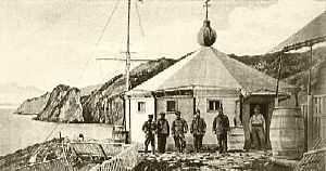
The only settlement is the Puerto Parry Naval Station, located in a deep and narrow fjord on the northern coast of the island. The naval station, established in 1978, is manned by a team of four marines on a 45-day rotation. They monitor environmental conservation and ship movements, and provide emergency assistance.[1]
History
The first Europeans in the area were Dutch explorers Jacob le Maire and Willem Schouten on December 25, 1615, who named the island Staten Landt, or "Country of the Lords of the State." Le Maire and Schouten sailed their ship, Eendracht, through a route south of the Straits of Magellan, a route now called the Le Maire Strait. To his left Le Maire noted the land mass which he called Staten Landt; he theorized it was perhaps a portion of the great 'Southern Continent.' (The first European name for New Zealand was Staten Landt, the name given to it by the Dutch explorer Abel Tasman, who in 1642 became the first European to see the islands. Tasman also assumed it was part of the 'Southern Continent' later known as Antarctica.
Dutch captain Hendrik Brouwer recorded sighting the island in 1643. No Europeans are known to have settled on the island for more than 200 years. In 1862 Argentine pilot Luis Piedrabuena established a shelter near Port Cook, and built a small seal oil extraction facility on the island.[2]
The island is also referenced in Richard Henry Dana Jr.'s book "Two Years Before the Mast" as the first land they see after leaving San Diego. He describes the land as ". . . bare, broken, and girt with rocks and ice, with here and there, between rocks and broken hillocks, a little stunted vegetation of shrubs. . ."
More than twenty years later, the Lighthouse of San Juan del Salvamento was inaugurated on May 25, 1884, by Comodoro Augusto Lasserre. It operated until September 1900. The lighthouse, better known as Faro del fin del mundo ("Lighthouse at the end of the world"), is said to have inspired Jules Verne's novel The Lighthouse at the End of the World (1905). A military prison was based on the island from 1899 to 1902. It had to be moved to Tierra del Fuego after being compromised by the strong winds.[3]
Geography
The island is approximately 65 kilometres (40 mi) long east-west, and 15 kilometres (9 mi) wide, with an area of 534 square kilometres (206 sq mi). The island is deeply indented by bays. Its highest point is 823 metres (2,700 ft), and is considered to be the last prominence of the Andes mountain range. It receives around 2,000 millimetres (79 in) of rain per year.
The island is surrounded by minor islands and rocks, the largest being Observatorio island 6.5 kilometres (4.04 mi) north, with an area of 4 square kilometres (2 sq mi).

Flora and fauna
Isla de los Estados is covered with dense low forests of Nothofagus southern beech. The animal life is composed mainly of penguins, orcas, seals, seagulls and cormorants, as well as the human-introduced deer and goats. The island is the location of one of the more southerly Atlantic breeding colonies of the Magellanic penguin.[4] As early as the last part of the 18th century, Isla de los Estados was used as a seal harvesting location.[5]
See also
Further reading
- Ponce, Juan Federico & Fernández, Marilén: Climatic and Environmental History of Isla de los Estados, Argentina. Springer, 2014. ISBN 978-94-007-4362-5 (print); ISBN 978-94-007-4363-2 (eBook)
References
- ↑ In search of the lighthouse at the end of the world. (In Spanish)
- ↑ La Isla de los Estados y el Faro del Fin del Mundo, By Carlos Pedro Vairo. Ed., Zagier & Urruty Publications. 1998. ISBN 1-879568-52-6
- ↑ Shipwrecks in Cape Horn-Staten Island, Malvinas and South Georgias, by Carlos Pedro Vairo. Ed., Zagier & Urruty Publications 2000. ISBN 1-879568-77-2
- ↑ C. Michael Hogan (2008) Magellanic Penguin, GlobalTwitcher.com, ed. N. Stromberg
- ↑ James Colnett, Robert Galois (2004) A Voyage to the North West Side of America: The Journals of James Colnett, 1786-89, published by UBC Press, ISBN 0-7748-0855-1, ISBN 978-0-7748-0855-2 441 pages
External links
- Isla de los Estados - InterPatagonia.com
- Isla de los Estados reserve (Spanish)