Iringa Region
| Iringa Region Mkoa wa Iringa (Swahili) | |
|---|---|
| Region | |
|
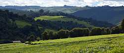
Tea fields in Mufindi | |
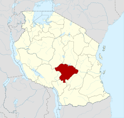 Regional map before partition in 2012 | |
| Country | Tanzania |
| Zone | Southern Highlands |
| Capital | Iringa |
| Government | |
| • Regional Commissioner | Christine Ishengoma |
| Area | |
| • Total | 35,503 km2 (13,708 sq mi) |
| Population (2012) | |
| • Total | 941,238 |
| • Density | 27/km2 (69/sq mi) |
| Time zone | EAT (UTC+3) |
| Postcode | 51xxx |
| Area code(s) | 026 |
| Website |
iringa |
Iringa is one of Tanzania's thirty administrative regions. The regional capital is Iringa. Prior to 2012 the total area was 58,936 square kilometers (22,755 sq mi), of which land area was 56,864 km sq (21,955 mi sq) and water area was 2,070 km² (800 mi sq);[1] however Iringa lost its three southern districts and considerable area in the creation of Njombe Region.
The former Iringa Region had a population of 1,495,333, according to the 2002 census.[2] The currently sized Iringa, the four old northern districts, had a combined population of 840,404 in the 2002 census.
Iringa Region is home to Ruaha National Park, Tanzania's second largest park, which has an abundance of wildlife and approximately 7,500 visitors per year. A second park, Udzungwa Mountains National Park in Iringa Rural District, is less visited.[3]
The Regional Commissioner of the Iringa Region is Christine G. Ishengoma.[4]
Districts
The region is administratively divided into three districts:
| Districts of Iringa Region | ||||||
|---|---|---|---|---|---|---|
| District | Population (2012) | |||||
| Iringa | 405,377 | |||||
| Kilolo | 218,130 | |||||
| Mufindi | 317,731 | |||||
| Total | 941,238 | |||||
References
- ↑ "Socio-Economic Profile of Iringa Region" (second ed.). The Planning Commission, Dar es Salaam, and The Regional Commissioner's Office, Iringa. May 2007. Archived from the original on 13 November 2010.
- ↑ "2002 Population and Housing General Report: Iringa". Archived from the original on 16 March 2004.
- ↑ "Focus on Tanzania". 2005. pp. 16–21.
|chapter=ignored (help) - ↑ "Tanzanian Government Directory Database" (in Swahili).
| ||||||||||||
Coordinates: 9°00′S 35°00′E / 9.000°S 35.000°E