Ipswich, Queensland
| Ipswich Ipswich, Queensland | |||||||||||||
|---|---|---|---|---|---|---|---|---|---|---|---|---|---|
|
Ipswich CBD & Bremer River as seen from Riverlink Shopping Centre, North Ipswich | |||||||||||||
| Population | 181,790 (2011; Statistical Area)[1] | ||||||||||||
| Established | 1846 | ||||||||||||
| Postcode(s) | 4305 | ||||||||||||
| Elevation | 50 m (164 ft) | ||||||||||||
| Time zone | AEST (UTC+10) | ||||||||||||
| Location | 40 km (25 mi) from Brisbane CBD | ||||||||||||
| LGA(s) | City of Ipswich | ||||||||||||
| Region | South East Queensland | ||||||||||||
| State electorate(s) | Ipswich, Ipswich West, Bundamba, Part of Lockyer | ||||||||||||
| Federal Division(s) | Blair, Oxley, Wright | ||||||||||||
| |||||||||||||

Ipswich is an urban centre in south-east Queensland, Australia. Situated on the Bremer River, it is approximately 40 kilometres (25 mi) west of the Brisbane CBD. The locality of the same name forms the Central Activities District, business and administrative centre of the City of Ipswich. The City of Ipswich has an estimated population of 185,000.
Once a large city of its own, today it has become subsumed into the Brisbane metropolitan area due to urban sprawl and is a part of Brisbane for statistical purposes.[2] It is a major commercial and industrial area that is currently undergoing major transit-oriented urban renewal, which was first planned in the Ipswich Regional Centre Strategy.[3]
It began as a mining settlement and was proclaimed as a municipality on 2 March 1860, and became a city in 1904.
Ipswich is home to the Safe City camera network installed into nine suburbs to date with further expansions proposed in the coming years. 180 cameras are monitored 24/7 from a facility situated within the CBD. The Ipswich City Council Safe City Monitoring Facility has hosted representatives of law enforcement agencies from the Netherlands, Taiwan, Great Britain and approximately twenty-five local authorities from across Australia to inspect the camera monitoring system.[4]
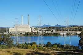
Plans are underway for Ipswich to contain the largest gas-fired power station in Australia and two new gas-fired power stations.
History


Prior to the arrival of European settlers, what is now called Ipswich was home to many indigenous language groups, including the Warpai tribe,[5] Yuggera and Ugarapul Indigenous Australian groups.[6] The area was first explored by European colonists in 1826, when Captain Patrick Logan, Commandant of the Moreton Bay penal colony, sailed up the Brisbane River and discovered large deposits of limestone and other minerals.[7]
The town began as a limestone mining settlement and grew rapidly as a major inland port. Ipswich was initially named Limestone, however in 1843 it was renamed after the town of Ipswich in England.[8] The population was 932 in 1851 and had risen to 2459 by 1856.[9] It became a municipality in 1858. Ipswich was a prime candidate for becoming capital of Queensland, but failed in its bid in favour of Brisbane in 1859.[10] It was proclaimed a city in 1904.[11]
In 1827, the first convicts and overseers arrived to mine the area. The town that built around this industry became known as Limestone and is remembered by one of the main streets through the Ipswich city centre.[12] In 1843, the settlement officially became known as Ipswich. The name change was proposed by surveyor Henry Wade and approved by Sir George Gipps, a soldier and Governor of New South Wales.[13] The town of Ipswich in England was once called Gipeswic,[14] derived from the Old English for "workplace by water".
From the 1840s onward, Ipswich was becoming an important river port for the growing local industries such as coal, and wool from the Darling Downs, so a regular paddlesteamer service from Brisbane Town, 'The Experiment', was established in 1846.[15] This, and other steamer services,[16] remained the primary form of mass/bulk transport between the two cities until 1876, when the construction of the original Albert Bridge, spanning the Brisbane River at Indooroopilly, completed the railway line begun between Ipswich and Brisbane in 1873.[17]
Father William McGinty, a native of Northern Ireland, took charge of Ipswich Roman Catholic Parish in 1852 and had the first St Mary's Church built. This building was described as "a rude slab building of small dimensions, without glass windows, only shutters." This church was later demolished and replaced by a "beautiful stone edifice of Gothic design" as quoted from a member of the church community. That was the old St. Mary's and it cost £7,000 in 1862.
Ipswich was proclaimed as a municipality on 2 March 1860 and became a city in 1904. The old Ipswich Town Hall, now an art gallery, served as the town hall from 1869 to about 1892, when it was found to be too small. It is on the Queensland Heritage Register. Damaging flooding has occurred on numerous occasions, the largest being the 1893 Brisbane flood peaking at 24.5 m, and more recently during the 1974 Brisbane Flood, peaking in Ipswich at 20.7 m. Collectively, 8500 houses were flooded in Ipswich and Brisbane.[18] In the 1893 flood seven workers were killed at a colliery in north Ipswich as the Bremer River broke its banks.[19]
In the 1980s and the 1990s, with land in nearby Brisbane becoming fully developed, and very expensive for housing, many new large scale housing estates became attractive for buyers in Ipswich with lower prices and bigger lots. Such new housing estates sprung up in Goodna, Brassall, Springfield Lakes, Collingwood Park, Redbank Plains with acreage estates in Karalee, Barellan Point, and Chuwar. The first masterplanned community in South East Queensland was subsequently established at Springfield.
Climate
Ipswich experiences a humid subtropical climate (Köppen climate classification Cfa) with hot and humid summers and mild to warm winters with cool overnight temperatures.
| Climate data for Ipswich-Amberley Air Base | |||||||||||||
|---|---|---|---|---|---|---|---|---|---|---|---|---|---|
| Month | Jan | Feb | Mar | Apr | May | Jun | Jul | Aug | Sep | Oct | Nov | Dec | Year |
| Record high °C (°F) | 44.3 (111.7) |
42.6 (108.7) |
38.9 (102) |
36.8 (98.2) |
33.3 (91.9) |
29.1 (84.4) |
29.6 (85.3) |
36.4 (97.5) |
39.2 (102.6) |
41.1 (106) |
42.1 (107.8) |
43.8 (110.8) |
44.3 (111.7) |
| Average high °C (°F) | 31.1 (88) |
30.4 (86.7) |
29.3 (84.7) |
27.2 (81) |
24.0 (75.2) |
21.6 (70.9) |
21.2 (70.2) |
22.7 (72.9) |
25.5 (77.9) |
27.7 (81.9) |
29.4 (84.9) |
30.8 (87.4) |
26.8 (80.2) |
| Average low °C (°F) | 19.6 (67.3) |
19.5 (67.1) |
17.7 (63.9) |
14.0 (57.2) |
10.0 (50) |
7.0 (44.6) |
5.3 (41.5) |
6.2 (43.2) |
9.5 (49.1) |
13.4 (56.1) |
16.3 (61.3) |
18.4 (65.1) |
13.1 (55.6) |
| Record low °C (°F) | 11.6 (52.9) |
11.1 (52) |
6.7 (44.1) |
1.0 (33.8) |
−3.1 (26.4) |
−4.3 (24.3) |
−4.8 (23.4) |
−4.9 (23.2) |
−0.2 (31.6) |
2.1 (35.8) |
4.9 (40.8) |
6.8 (44.2) |
−4.9 (23.2) |
| Average precipitation mm (inches) | 116.5 (4.587) |
122.4 (4.819) |
82.8 (3.26) |
56.0 (2.205) |
52.9 (2.083) |
46.1 (1.815) |
39.1 (1.539) |
28.8 (1.134) |
33.3 (1.311) |
74.2 (2.921) |
81.7 (3.217) |
121.4 (4.78) |
854.8 (33.654) |
| Avg. precipitation days | 10.9 | 11.9 | 11.3 | 8.0 | 7.7 | 6.3 | 6.5 | 5.7 | 5.9 | 8.8 | 9.3 | 10.6 | 102.9 |
| Average relative humidity (%) | 51 | 54 | 52 | 48 | 48 | 46 | 42 | 38 | 38 | 43 | 46 | 49 | 46 |
| Source: Bureau of Meteorology[20][21] | |||||||||||||
Economy

Ipswich was a major mining centre, particularly coal mining. The city is the 'cradle of coal mining in Queensland'.[22] Other secondary manufacturing industries included earthenware works, sawmills, abattoirs and foundries, while the region is also rich agriculturally.
Ipswich is the site of RAAF Base Amberley, the Royal Australian Air Force's largest operational base. RAAF Amberley is currently home to No. 1 and No. 6 Squadrons flying the Boeing F/A-18F Super Hornet. No. 36 Squadron (flying C-17 Globemaster III transport aircraft) are also based out of Amberley. In addition a number of ground support units are located at Amberley. The airbase is currently being expanded and will eventually also house No. 33 Squadron (flying Airbus A330 MRTT tanker-transports) and several Army units.
Ipswich is also home to a campus of the University of Queensland, the annual Ipswich Cup horse races one of the biggest race meets in Queensland where over 24,000 attend, and The Workshops Railway Museum to commemorate the first trainline in Queensland from Ipswich to Grandchester (Bigges Camp), approximately 25 kilometres (16 mi) to the west. The present Ipswich Station is a major transport interchange.
Ipswich has been called 'The City of Churches' with a number of denominations' first churches in Queensland being in Ipswich.
A large shopping complex is being developed in the eastern suburb of Springfield. Accompanying this is a satellite campus of the University of Southern Queensland, which has its primary campus in Toowoomba. Redbank Plaza shopping mall has had eight cinemas added as well as a fourth floor of shopping. Three clear retail and service hubs are developing outside Ipswich central and besides Springfield. Brassall and Karalee to the north, Yamanto to the South, and Booval in the central east.
Housing
.JPG)
The traditional Ipswich dwelling has always been a detached home on land, and is frequently portrayed in the paintings of D'Arcy Doyle, however this is changing as housing demand and a desire to live closer to amenities increases. New estates and suburbs are currently under development in the south-eastern section of the city as well as Ripley Valley.
Infrastructure
Health
Ipswich Hospital is the major public hospital in the city. St Andrew's Private Hospital is the city's only major private hospital.
Transport
The main form of transport in Ipswich is the private vehicle. Ipswich also has direct access to the Ipswich Motorway (linking to Brisbane); the Cunningham Highway (linking to Warwick); the Warrego Highway (linking to Toowoomba); and the Centenary Highway (linking Springfield and the Ripley Valley to Brisbane).

Ipswich Railway Station is a major hub for rail transport. The electrified rail line that runs from Ipswich through Brisbane's western suburbs to the Brisbane CBD is known as the Ipswich Line. The Rosewood railway line is also electrified and continues west through Ipswich's western suburbs to the town of Rosewood. Both lines are operated by Queensland Rail. A rail line has been proposed to run south from Ipswich to Yamanto and Ripley, eventually connecting with the Springfield line.[23] The Westlander, operated by Traveltrain stops at Ipswich Station twice a week on its journey to and from Charleville and stops along the way include Toowoomba.
Ipswich is also the hub of a large bus network. Westside Buslines is the prominent bus company in Ipswich, linking all sides of town to Ipswich CBD; Redbank; Springfield; or Forest Lake (in Brisbane). They also operate services on behalf of Queensland Rail to Fernvale, Lowood, Coominya, Esk, and Toogoolawah. Bus Queensland Lockyer Valley operates bus services on behalf of Queensland Rail to Gatton and Helidon. An Airport Express Bus operates from Ipswich to Brisbane Airport on a regular basis. Prior bookings are essential though. Greyhound Australia offers daily direct services to Toowoomba, Mount Isa, Charleville, Sydney and Melbourne from the Ipswich Transit Centre. Crisps Coaches offer daily direct services to and from Warwick and Stanthorpe.
Bicycle transport is not well facilitated in Ipswich, although there are some marked on-road lanes there are few segregated bicycle facilities. A 65 kilometres (40 mi) trail linking Ipswich to Boonah includes bicycle and walking paths is currently under construction.[24] A new cycleway has been created at Brassall. The bikeway is 2.6 kilometres (1.6 mi) long and connects the suburbs of Brassall and North Ipswich. Further bikeways are being constructed, such as the link to Redbank Plains High school and by the utilization of the former Brisbane Valley Rail line, which will connect Wulkuraka to Blackbutt.
Utilities
Water for Ipswich is supplied by Queensland Urban Utilities. The main water supply is Lake Wivenhoe which is connected to the South East Queensland Water Grid with secondary supplies at Lake Somerset. Water restrictions were lifted on 01 January 2013.
Sport
- Association football: The Ipswich Knights play in the Brisbane Premier League competition. As of 2013, a new team, the Western Pride, plays in the newly formed National Premier League (NPL). Other teams playing in Ipswich include the Ipswich City Bulls & Western Spirit.
- Australian rules football: The Ipswich Eagles play in second tier division of AFL Queensland, and Collingwood Park Power play in Division 3. The Ipswich Miners play in the under 18 competition of AFL Queensland. Collingwood Park(Power), Ipswich Central (Cats)and Springfield Lakes play in the junior competition of AFL Brisbane Juniors.
- Brookwater Golf Club, designed by Greg Norman, is located in Springfield.
- Drag Racing is conducted at Willowbank Raceway year round with events open to both professional and amateur racers, including a series conducted to facilitate newcomers to the sport.
- Gridiron: The Ipswich Cougars play in the Gridiron Queensland league and have been one of the most dominant teams since the launch of Gridiron in Queensland.
- Hockey is a major sport in the city and is played at Briggs road facility where there are 2 artificial surfaces that are world class.
- Rugby League: The Ipswich Jets play in the Queensland Cup competition, FOGS and FOGS Colts. Ipswich Diggers are the junior representative teams playing all other QLD regions in the Mal Meninga & Cyril Connell Statewide Cups. Ipswich also has a thriving local league competition including 4 grades of Seniors and every age group of juniors (multiple divisions). Clubs include West End Bulldogs, Brothers, Swifts, Goodna Eagles, Springfield, Norths Tigers, Laidley Lions, Fassifern Bombers, Redbank Bears, Lowood Stags, Twin Rivers, Rosewood Roosters and Brisbane Valley.
- Rugby Union: The Ipswich Rangers play in the Brisbane Suburban Rugby competition usually competing with 3–4 grades including Colts. The Rangers juniors compete in the Brisbane Junior Rugby competition.
- The V8 Supercars race each year at Queensland Raceway at Willowbank in mid July.
Residents
Sportspeople
- Deborah Acason, represented Australia in weightlifting, Commonwealth Games (2006 Gold Medal, 2002 Silver Medal) and Olympics (2008 eighth place, 2004 twelfth place).
- Greg Ball, Paralympic cyclist[25]
- Berrick Barnes, dual code rugby footballer and Wallabies player (attended Ipswich Grammar School)
- Ashleigh Barty, professional tennis player
- John Buchanan, former Australian cricket team coach
- Allan Davis, Professional road racing cyclist for UCI ProTour team Orica-GreenEDGE, Winner of the 2009 Tour Down Under
- Israel Folau, professional dual code footballer Australian rugby league representative and Australian rules footballer with the Greater Western Sydney Football Club. Played for Ipswich junior rugby league team Goodna Eagles.[26]
- Rhan Hooper, professional Australian rules footballer in the Australian Football League (AFL) (attended Bundamba State Secondary College)
- Luke Keary, NRL player for The South Sydney Rabbitohs, grew up in the suburb of Raceview, attended St Mary's Primary School, played for Brothers Ipswich JRLFC.
- Noel (Ned) Kelly, NRL player for Goodna, Railways, Brothers Ipswich, Western Suburbs Magpies, Queensland and Australian Kangaroos (1959-60; 1963-64 & 1967-68). Hooker in Queensland Rugby League's Team of the Century. Attended St Edmund's Christian Brothers College.
- Allan Langer, rugby league player, attended Ipswich State High School and Blair State Primary School
- Craig McDermott, represented Queensland and Australia in cricket, attended Ipswich Grammar School.
- The McLean Family, see McLean Family
- Des Morris, Queensland rep and current Australian selector (attended Bremer High School)
- Rod Morris, former Balmain, Queensland, NSW and Australian Front
- Lagi Setu, NRL Player for The Brisbane Broncos (attended Ipswich Grammar School)
- Dale Shearer, rugby league player who represented Queensland and Australia at rugby league
- Lama Tasi, NRL Player for The Sydney Roosters (attended Ipswich Grammar School)
- Mark Tonelli, Olympic gold medallist in swimming, member of the Quietly Confident Quartet.
- The "Walters Brothers", rugby league players: Kevin Walters, Kerrod Walters and Steve Walters
- Shane Watson, represented Queensland and Australia in cricket, attended Ipswich Grammar School.
- Rosie Milgate, represented Australia in swimming at 1976 Olympics whilst still a student attending Bremer State High School.
Politicians
- Ian Berry, LNP State Member for Ipswich (2012-)
- Neville Bonner, The first indigenous Australian to become a member of the Parliament of Australia.
- Llewellyn Edwards, entered Queensland state parliament as the Liberal Party Member for Ipswich Liberal Party of Australia in 1972. In 1984 he was made a Knight Bachelor, and in 1989, a Companion of the Order of Australia.
- David Hamill, attended Bremer High School and was dux. He was a Queensland labour minister in the Goss government
- Pauline Hanson, former member of the Liberal Party of Australia, Independent member for Oxley (1996–1998) and founder of the One Nation Party.
- Bill Hayden, former Governor General of the Commonwealth of Australia, leader of federal Australian Labor Party.
- Shayne Neumann, present Labor member for Blair (2007–present)
- Cameron Thompson, former Liberal member for Blair (1998–2007).
- Paul Pisasale, Mayor from 2004 to present.
Musicians
- Harold Blair, Aboriginal Tenor and music teacher
- Luke Kennedy, singer, finalist The Voice Australia
- Matthew Hickey, singer, founder and director of The Ten Tenors
- David McCormack, former lead member of Custard and The Titanics.
- Thomas Shapcott, Author and poet
- Hazza, Television presenter and singer
Other
- John Birmingham, (Liverpool-born) Author
- John Bradfield, Engineer and designer of the Sydney Harbour Bridge; Story Bridge; and the Sydney Railway System
- Joy Chambers, Author, Actor
- D'Arcy Doyle, Painter
- Sir Harry Gibbs, Chief Justice of the High Court of Australia
- Sir Samuel Griffith, Chief Justice of the High Court of Australia
- Rev Trevor Foote, Author, Medal of the order of Australia recipient.
- George Roberts, Aviation Pioneer
Education
Colleges and universities
- Auto Trade College, Bundamba
- Bremer Institute of TAFE, Ipswich, Bundamba, Sprinfield Lakes, and Goodna
- University of Queensland and University of Southern Queensland Ipswich
- University of Southern Queensland, Springfield
Secondary schools

Ipswich has a considerable number of secondary schools, including the following:
- Bremer State High School
- Bundamba State Secondary College
- Ipswich Girls' Grammar School, established 1892
- Ipswich Grammar School, established in 1863, first school to open as a result of the Grammar Schools Act of 1860
- Ipswich State High School
- Redbank Plains State High School
- Rosewood State High School
- Saint Edmund's College
- Saint Mary's College
- Springfield Central State High School
- The Springfield College
- St Augustine's College Springfield
- St Peter Claver College
- West Moreton Anglican College, Karrabin
- Westside Christian College
- Woodcrest State College
Primary schools

Ipswich has a number of primary schools, including the following:
- Amberley District State Primary School (replacing Amberley State Primary School)
- Blair State Primary School
- Brassall State Primary School
- Bundamba State Primary School
- Camira State School
- Central State Primary School
- Churchill State Primary School
- Collingwood Park State School
- East Ipswich State Primary School
- Goodna State School, established in 1870.
- Ipswich State School
- Karalee State Primary School
- North Ipswich State Primary School
- Redbank Plains State School
- Redbank State Primary School
- Riverview State School
- Sacred Heart Primary School
- Silkstone State School
- Springfield Lakes State School
- St Marys Primary school
- St Josephs Primary School
- St Francis Xavier Primary School
- Tivoli State Primary School
- West Ipswich State Primary School
- Woodlink State School
Events
Ipswich Show
The first Ipswich Annual Show was held on 2 April 1873 by the Queensland Pastoral and Agricultural Society. There had been shows staged by the Ipswich and West Moreton Horticultural and Agricultural Society as early as 1868. Originally held at the sale yards situated at Lobb St, Churchill, the show moved to its present home at the Ipswich Showgrounds in 1877.

Goodna Jacaranda Festival
This festival has been held annually at Goodna (Evan Marginson Sportsground) since 1968, over 10,000 people attend this three-day event. The festival features a talent quest, school band competition, fun run, live entertainment as well as the regular attractions such as sideshow alley, food and stalls.
Since 2009 the festival has had its own website.. In 2010, it joined Facebook.
Ipswich Festival
The Ipswich Festival is an annual multi-disciplinary festival that fosters and encourages an atmosphere, which brings families together to enjoy the many free attractions. The Ipswich Festival showcases a broad and bold program of entertainment and arts that continues to entertain, inspire and celebrate the essence of our City's culture, spirit and community to the highest calibre.
First staged in 1998, the Ipswich Festival has enjoyed a 13-year development strategy, and the planning, programming and production are professionally managed by an experienced team of individuals who are highly regarded as specialists in creating and managing festivals and community event.
The Ipswich Festival is regarded as the City's premier event and over the past 13 years, the variety, size and scope of the program has grown exponentially through increasing interest group participation, corporate partnerships and community enthusiasm through the presentation of a festival that `celebrates its city'.
The festival presents Ipswich's cultural heritage and highlights the city's emerging talents through a deliberate program of Live Bands, Concerts, Art exhibits, Fireworks, Theatre, Jazz, Multicultural Celebrations, interactive displays and a range of family-based events to encourage participation by all age groups whilst attracting day tourism to the region.
The Ipswich Festival runs for two weeks at the end of April beginning of May with the majority of events free.
References
- ↑ Australian Bureau of Statistics (31 October 2012). "Ipswich (Statistical area 4)". 2011 Census QuickStats. Retrieved 16 February 2014.
- ↑ http://www.oesr.qld.gov.au/products/maps/qld-sd-wall-maps/sd-qld-2008.pdf
- ↑ http://www.dip.qld.gov.au/local-area-planning/transit-oriented-development.html
- ↑ "Rats cause CCTV chaos". Queensland Times. 26 May 2010. Retrieved 4 December 2014.
- ↑ Tom Petrie's Reminiscences of Early Queensland. St Lucia, Queensland: University of Queensland Press. 1992. p. 102. ISBN 0702223832.
- ↑ http://www.ipswich150.com.au/proud_past
- ↑ Extract from Captain Patrick Logans' Journal – The Sydney Gazette and New South Wales Advertiser (NSW : 1803–1842)
- ↑ "Place name details – Ipswich". Queensland Government. Retrieved 16 January 2012.
- ↑ Knight, J.J. "Brisbane : a historical sketch of the capital of Queensland, giving an outline of old-time events, with a description of Brisbane of the present day, and a municipal retrospect". Biggs & Morcom. p. 24. Retrieved 2013.
- ↑ http://www.epa.qld.gov.au/chims/placeDetail.html?siteId=20499
- ↑ http://www.ipswich.qld.gov.au/about_council/council_history/index.php
- ↑ Explore Australia, p.480, 2002, Viking
- ↑ Place name details
- ↑ England's Oldest Town
- ↑ The Steamer "Experiment" – The Moreton Bay Courier – 20 June 1846
- ↑ Ipswich City Council – Heritage Education Kit – Transport
- ↑ Queensland Rail – Queensland's First Railway
- ↑ Flood Warning System for the Bremer River to Ipswich
- ↑ "Australia floods: history of Queensland's worst floods". The Telegraph (Telegraph Media Group Limited). 13 January 2011. Retrieved 24 May 2014.
- ↑ "Charleville Aero". Climate statistics for Australian locations. Bureau of Meteorology. Retrieved 21 September 2013.
- ↑ "AMBERLEY AMO". Climate statistics for Australian locations. Bureau of Meteorology. Retrieved 9 February 2014.
- ↑ http://www.newhopecoal.com.au/about-us/history.aspx
- ↑ "Connecting SEQ 2031: An Integrated Regional Transport Plan for South East Queensland" (PDF). Department of Transport and Main Roads. 2011.
- ↑ http://www.dip.qld.gov.au/regional-planning/boonah-to-ipswich-trail.html
- ↑ "Greg Ball profile". Australian Paralympic Committee. 2000. Archived from the original on 5 December 2000. Retrieved 25 January 2012.
- ↑ Eagles grounded by Folau move Chris Garry for Queensland Times 4 May 2010
External links
| Wikimedia Commons has media related to Ipswich, Queensland. |
- University of Queensland: Queensland Places: Ipswich
- City Council website
- Independently run information site
- Ipswich 150 Anniversary – Ipswich, Queensland
- 2011 Flood Appeal – Ipswich United from Ipswich, Suffolk
- watch historical footage of Ipswich and Southern Queensland
Coordinates: 27°37′S 152°46′E / 27.617°S 152.767°E
| ||||||||||||||
| ||||||||||