Ionian Sea
| Ionian Sea | |
|---|---|
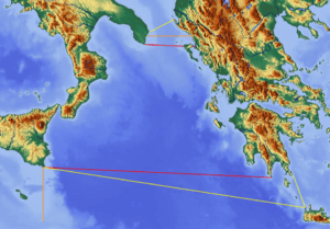
 Map of the Ionian Sea | |
| Location | Europe |
| Type | Sea |
| Primary outflows | Mediterranean Sea |
| Basin countries | Greece, Italy, Albania |
| Islands | List of islands in the Ionian Sea |
| Settlements | Igoumenitsa, Parga, Preveza, Astakos, Patras, Kerkyra, Lefkada, Argostoli, Zakynthos, Kyparissia, Pylos, Kalamata, Himarë, Saranda, Syracuse, Catania, Taormina, Messina, Taranto |


The Ionian Sea (Greek: Ιόνιο Πέλαγος, Greek pronunciation: [iˈonio ˈpelaɣos], Italian: Mar Ionio, Italian pronunciation: [mar ˈjɔːnjo], Albanian: Deti Jon) is an elongated embayment of the Mediterranean Sea, south of the Adriatic Sea. It is bounded by southern Italy including Calabria, Sicily, and the Salento peninsula to the west, southern Albania to the north, and west coast of Greece.
All major islands in the sea belong to Greece. They are collectively referred to as the Ionian Islands, the major ones being Corfu, Zakynthos, Kephalonia, Ithaca, and Lefkada. There are ferry routes between Patras and Igoumenitsa, Greece, and Brindisi and Ancona, Italy, that cross the east and north of the Ionian Sea, and from Piraeus westward. Calypso Deep, the deepest point in the Mediterranean at −5,267 m (−17,280 ft), is located in the Ionian Sea, at 36°34′N 21°8′E / 36.567°N 21.133°E.[1][2] The sea is one of the most seismically active areas in the world.
Name
The name Ionian comes from Greek language Ἰόνιον (πέλαγος). Its etymology is unknown.[3] Ancient Greek writers, especially Aeschylus, linked it to the myth of Io. In Ancient Greek the adjective Ionios (Ἰόνιος) was used as an epithet for the sea because Io swam across it.[4] There were also narratives about other eponymic legendary figures; according to one version, Ionius was a son of Adrias (eponymic for the Adriatic Sea); according to another, Ionius was a son of Dyrrhachus, eponymic for the ancient Illyrian city of Dyrrhachium (modern Durrës in Albania). When Dyrrhachus was attacked by his own brothers, Heracles, who was passing through the area, came to his aid, but in the fight the hero killed his ally's son by mistake. The corpse was cast into the sea, which thereafter was called the Ionian Sea.
Geography
Extent
The International Hydrographic Organization defines the limits of the Ionian Sea as follows:[5]
- On the North. A line running from the mouth of the Butrinto River (39°44'N) in Albania, to Cape Karagol in Corfu (39°45'N), along the North Coast of Corfu to Cape Kephali (39°45'N) and from thence to Cape Santa Maria di Leuca in Italy.
- On the East. From the mouth of the Butrinto River in Albania down the coast of the mainland to Cape Matapan.
- On the South. A line from Cape Matapan to Cape Passero, the Southern point of Sicily.
- On the West. The East coast of Sicily and the Southeast coast of Italy to Cape Santa Maria di Leuca.
Places
From south to north in the west, then north to south in the east:
- Syracuse, port, W
- Catania, port, W
- Messina, port, W
- Taranto, port N
- Himara, small port, NE
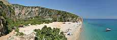
- Saranda, port and a beach, NE
- Kerkyra, port, E
- Igoumenitsa, port, E
- Parga, small port, E
- Preveza, port, E
- Astakos, port, E
- Argostoli, small port, E
- Patra, port, E
- Kyparissia, port, E
- Pylos, port, E
- Methoni, small port and a beach
- Ionian Islands
Gulfs and straits
- Strait of Messina, W
- Gulf of Catania, W
- Gulf of Taranto, NW
- Gulf of Squillace, NW
- Ambracian Gulf, E
- Gulf of Patras, connecting the Gulf of Corinth, ESE
- Gulf of Kyparissia, SE
- Messenian Gulf, SE
- Laconian Gulf, ESE
See also
| Wikimedia Commons has media related to Ionian Sea. |
References
- ↑ Barale, Vittorio (2008). "The European Marginal and Enclosed Seas: An Overview". In Vittorio Barale and Martin Gade (eds). Remote Sensing of the European Seas. Springer Science+Business Media. pp. 3–22. ISBN 978-1-4020-6771-6. LCCN 2007942178. Retrieved 28 August 2009.
- ↑ NCMR - MAP
- ↑ Babiniotis, Lexiko tis Neoellinikis Glossas.
- ↑ LSJ, A Greek-English Lexicon s.v. Ἰόνιος.
- ↑ "Limits of Oceans and Seas, 3rd edition" (PDF). International Hydrographic Organization. 1953. Retrieved 7 February 2010.
External links
- Preveza Weather Station SV6GMQ - Live Weather Conditions (in English and Greek)
| ||||||||||||||||||||||||||||||||||||||||||||||||||||||||||||||||||||||||||||||||||||||||||||||||||||||||||||||||||||||||||||||||||||||||||||||||||