Inukjuak, Quebec
| Inukjuak ᐃᓄᒃᔪᐊᒃ | |
|---|---|
| Northern village municipality | |
 Inukjuak | |
| Coordinates: 58°27′N 78°06′W / 58.450°N 78.100°WCoordinates: 58°27′N 78°06′W / 58.450°N 78.100°W[1] | |
| Country |
|
| Province |
|
| Region | Nord-du-Québec |
| TE | Kativik |
| Constituted | 7 June 1980 |
| Government[2] | |
| • Mayor | Siasi Iqrumia |
| • Federal riding | Abitibi—Baie-James—Nunavik—Eeyou |
| • Prov. riding | Ungava |
| Area[2][3] | |
| • Total | 64.40 km2 (24.86 sq mi) |
| • Land | 55.63 km2 (21.48 sq mi) |
| Population (2011)[3] | |
| • Total | 1,597 |
| • Density | 28.7/km2 (74/sq mi) |
| • Change (2006–11) | 0.0% |
| • Dwellings | 444 |
| Time zone | EST (UTC−5) |
| • Summer (DST) | EDT (UTC−4) |
| Postal code(s) | J0M 1M0 |
| Area code(s) | 819 |
| Website |
www |
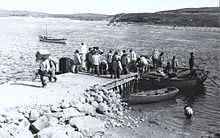
Inukjuak (Inuktitut: ᐃᓄᒃᔪᐊᒃ) (Inuktitut for The Giant) is a northern village (Inuit community) located on Hudson Bay at the mouth of the Innuksuak River in Nunavik, in the Nord-du-Québec region of northern Quebec, Canada. Its population is 1,597 as of the Canada 2011 Census. An older spelling is Inoucdjouac;[4] its former name was Port Harrison.
It is not accessible by road, but by boat in summer and year-round by air through Inukjuak Airport.
"The Giant" is the literal translation of the word Inukjuak, but originally it was Inurjuat, which means "many people". In the past there was an Inuk (singular for the word Inuit) who went down to the river of Inukjuak to fetch some water. While there, the person saw many Inuit in kayaks approaching from the mouth of the river, and then yelled back out to the community "Inurjuat! Inurjuat!". That is where the name for the community comes from.
History
The many archeological sites near Inukjuak indicate that the area has long been inhabited by Inuit.
At the beginning of the 20th century, the Révillon Frères company set up a fur trading post in Inukjuak, originally called Port Harrison. In order to compete with them, the Hudson's Bay Company (HBC) established a post in 1920. In the same year Révillon Frères paid for Robert J. Flaherty to film Nanook of the North (released 1922) in the area.
The HBC bought out Révillon Frères in 1936 and continued its trade monopoly here until 1958. In 1927 an Anglican mission was established, followed by a post office and RCMP detachment in 1935, a nursing station in 1947, and a school in 1951. From this time on the Inuit started to give up their traditional nomadic way of life and live permanently in the community. A cooperative store was formed in 1962. Inukjuak was legally established as a municipality in 1980.
In 1953, the Canadian government forcibly relocated some of the area's inhabitants to Resolute and Grise Fiord—then in the Northwest Territories, but now part of Nunavut—as part of a plan to establish a Canadian presence in the High Arctic and assert its sovereignty (see human flagpoles). This caused families to be split up and relocated persons faced hardships in the much more severe conditions of the far north.
Climate
Inukjuak has a polar climate with a July average of 9.4 °C (48.9 °F) and February average of −25.8 °C (−14.4 °F).
| Climate data for Inukjuak | |||||||||||||
|---|---|---|---|---|---|---|---|---|---|---|---|---|---|
| Month | Jan | Feb | Mar | Apr | May | Jun | Jul | Aug | Sep | Oct | Nov | Dec | Year |
| Record high °C (°F) | 0.6 (33.1) |
5 (41) |
3.9 (39) |
7.2 (45) |
23.3 (73.9) |
30 (86) |
27.8 (82) |
25.6 (78.1) |
22.8 (73) |
16.7 (62.1) |
8.3 (46.9) |
16.1 (61) |
30 (86) |
| Average high °C (°F) | −21 (−6) |
−21.6 (−6.9) |
−16.3 (2.7) |
−7.1 (19.2) |
1.2 (34.2) |
8.4 (47.1) |
13.2 (55.8) |
12.5 (54.5) |
7.7 (45.9) |
2 (36) |
−4.2 (24.4) |
−15 (5) |
−3.4 (25.9) |
| Daily mean °C (°F) | −24.8 (−12.6) |
−25.8 (−14.4) |
−21.2 (−6.2) |
−11.7 (10.9) |
−1.9 (28.6) |
4.6 (40.3) |
9.4 (48.9) |
9.2 (48.6) |
5.1 (41.2) |
−0.3 (31.5) |
−7.4 (18.7) |
−18.9 (−2) |
−7 (19) |
| Average low °C (°F) | −28.6 (−19.5) |
−29.9 (−21.8) |
−26.1 (−15) |
−16.3 (2.7) |
−5.1 (22.8) |
0.8 (33.4) |
5.5 (41.9) |
5.9 (42.6) |
2.5 (36.5) |
−2.6 (27.3) |
−10.6 (12.9) |
−22.7 (−8.9) |
−10.6 (12.9) |
| Record low °C (°F) | −46.1 (−51) |
−49.4 (−56.9) |
−45 (−49) |
−34.4 (−29.9) |
−25.6 (−14.1) |
−9.4 (15.1) |
−6.7 (19.9) |
−2.8 (27) |
−11.1 (12) |
−22.8 (−9) |
−33.9 (−29) |
−43.3 (−45.9) |
−49.4 (−56.9) |
| Average precipitation mm (inches) | 14.4 (0.567) |
11.6 (0.457) |
15.5 (0.61) |
22.6 (0.89) |
27 (1.06) |
38.2 (1.504) |
60.1 (2.366) |
61.1 (2.406) |
70.1 (2.76) |
58.6 (2.307) |
50.6 (1.992) |
30.3 (1.193) |
559.9 (22.043) |
| Average rainfall mm (inches) | 0 (0) |
0.1 (0.004) |
0.1 (0.004) |
3.6 (0.142) |
12.6 (0.496) |
33.6 (1.323) |
59.5 (2.343) |
61.1 (2.406) |
62.2 (2.449) |
28.2 (1.11) |
3.2 (0.126) |
0.4 (0.016) |
264.6 (10.419) |
| Average snowfall cm (inches) | 15 (5.9) |
12 (4.7) |
16.1 (6.34) |
19.4 (7.64) |
14.6 (5.75) |
4.4 (1.73) |
1.0 (0.39) |
0 (0) |
7.5 (2.95) |
32.6 (12.83) |
50.0 (19.69) |
32.0 (12.6) |
204.6 (80.52) |
| Mean monthly sunshine hours | 63.5 | 122.5 | 182.5 | 183.2 | 159.4 | 209.4 | 226.0 | 171.7 | 97.9 | 50.4 | 31.8 | 35.2 | 1,533.5 |
| Source: Environment Canada[5] | |||||||||||||
References
- ↑ Reference number 98657 of the Commission de toponymie du Québec (French)
- ↑ 2.0 2.1 Geographic code 99085 in the official Répertoire des municipalités (French)
- ↑ 3.0 3.1 "(Code 2499085) Census Profile". 2011 census. Statistics Canada. 2012.
- ↑ Native Names for Native Places, Natural Resources Canada.
- ↑ Environment Canada Canadian Climate Normals 1971–2000, accessed 24 July 2009
Further reading
- Melanie McGrath, The Long Exile: A Tale of Inuit Betrayal and Survival in the High Arctic. ISBN 0-00-715796-7 (London: Fourth Estate, 2006) and ISBN 1-4000-4047-7 (New York: Random House, 2007). The story of forced removal of Inuit peoples in Canada in 1953, including Robert Flaherty's illegitimate Inuit son Joseph.