Interstate 94 in Minnesota
| ||||
|---|---|---|---|---|
|
Interstate 94 highlighted in red | ||||
| Route information | ||||
| Maintained by Mn/DOT | ||||
| Length: | 259.49 mi[1] (417.61 km) | |||
| Major junctions | ||||
| West end: |
| |||
|
| ||||
| East end: |
| |||
| Location | ||||
| Counties: | Clay, Wilkin, Otter Tail, Grant, Douglas, Todd, Stearns, Wright, Hennepin, Ramsey, Washington | |||
| Highway system | ||||
| ||||

_map.svg.png)
In the U.S. state of Minnesota, Interstate 94 runs east–west through the central portion of the state. The route connects the cities of Moorhead, Fergus Falls, Alexandria, St. Cloud, Minneapolis, and Saint Paul.
Interstate 94 in Minnesota is 259 miles (417 km) in length.
Route description
Interstate 94 enters the state from North Dakota at the city of Moorhead and immediately heads southeast.
Traveling southeast from Moorhead, there are several places where the elevation of I-94 rises slightly; these are "beaches" that formed as the glacial lake rose or fell. Finally, at Rothsay, I-94 climbs the last beach line and enters terrain more typical for Minnesota. From Rothsay to the Twin Cities, the terrain of I-94 is rolling with frequent lakes visible from the highway.
I-94 traverses by Fergus Falls, Alexandria, and Sauk Centre on its way to St. Cloud. The "original main street" in Sauk Centre near I-94 commemorates the Sinclair Lewis novel that skewered this town.
From St. Cloud to Minneapolis, it's difficult to tell where the sprawl from one city ends and the other begins. Monticello is roughly the midpoint, and is an exurb for both St. Cloud and Minneapolis. Between exits 201 (Albertville) and 194 (Monticello) sits the Minnesota Road Research Facility.
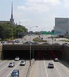
Upon arrival to the Twin Cities, I-94 approaches first Minneapolis from the north, then the highway turns east after passing through the Lowry Hill Tunnel and heads to Saint Paul. Upon leaving Saint Paul, the route travels through suburban Washington County and exits the state into Wisconsin.
Legally, the Minnesota section of Interstate 94 is defined as unmarked Legislative Route 392 in the Minnesota Statutes § 161.12(4). Interstate 94 is not marked with this legislative number along the actual highway.
History
Interstate 94 in Minnesota was authorized as part of the original interstate network in 1956. It was mostly constructed in the 1960s.
I-94 follows the original route of old U.S. Highway 52 from Moorhead to St. Cloud, then I-94 stays south of the Mississippi River along the former route of old State Highway 152 between St. Cloud and the Twin Cities. I-94 then passes through both downtowns and exits toward Wisconsin along the former route of old U.S. Highway 12.
The first section of I-94 in Minnesota constructed was between Moorhead and Albany in the early 1960s.
The section of I-94 between Minneapolis and Saint Paul was completed in 1964.
The section of I-94 between Maple Grove and Brooklyn Center was completed in 1969.
The section of I-94 between Saint Augusta and Maple Grove was completed in 1973.
The section of I-94 between Albany and Saint Augusta was completed in 1977.
The section of I-94 from Brooklyn Center through north Minneapolis was completed in 1984.
The last section of I-94 in Minnesota constructed was the ten miles (16 km) between its junction with I-494 / I-694 at Woodbury and the Wisconsin state line at Lakeland. This was completed in 1985.
In 2004, a major traffic bottleneck was relieved when a third lane was constructed between Brooklyn Boulevard at Brooklyn Center and Hemlock Lane at Maple Grove. This is located immediately east of the I-494 / 694 / 94 interchange in Maple Grove, also known locally as the Fish Lake Interchange.
Notes
- 40 miles (64 km) north of the Twin Cities near Albertville, the Minnesota Department of Transportation (Mn/DOT) operates the Minnesota Road Research Facility, which studies the effect of traffic on various road surface types. Westbound traffic is redirected onto 3.5 miles (5.5 km) of pavement outfitted with thousands of sensors. There is a straight-through bypass (the original highway) that can be used when researchers are examining the road up close.
- U.S. Highway 52 is invisibly concurrent with Interstate 94 between the city of Moorhead and downtown Saint Paul. U.S. 52 is signed on maps for this portion, but not along the actual highway.
- U.S. Highway 12 is invisibly concurrent with Interstates 94 and 394 through Minneapolis and Saint Paul to the Minnesota/Wisconsin state line at Hudson. U.S. 12 is signed on maps for this portion, but only briefly along the actual highway.
- Following the I-35W Bridge collapse on August 1, 2007, the detour for I-35W followed I-94 from I-35W to State Highway 280. I-94 was quickly widened by a lane in each direction for this portion to accommodate the additional traffic burden. This detour ended on September 18, 2008 when a new bridge replacing the collapsed span opened.
Auxiliary routes
- I-394 - Direct link between Minneapolis and western suburbs
- I-494 - Southern/western portion of beltway loop
- I-694 - Northern/eastern portion of beltway loop
Lane configurations
- 3 lanes in both directions from the North Dakota state line to U.S. 75 (Moorhead).
- 2 lanes in both directions from U.S. 75 to State Highway 101 (Rogers).
- 3 lanes in both directions from State Highway 101 to I-494 (Maple Grove).
- 4 lanes eastbound between I-494 and U.S. 169, 4 lanes westbound between Boone Avenue and Hemlock Lane (Maple Grove).
- 3 lanes each direction from Boone Avenue to Brooklyn Blvd.
- 4 lanes each direction between Brooklyn Blvd. to the I-94 split from I-694.
- 2 lanes each direction transitioning from I-694 mainline to I-94 mainline. (Brooklyn Center).
- 4 lanes in both directions from I-694 / State Highway 252 to Dowling Avenue (Minneapolis).
- 5 lanes (with the exception of 4 under Broadway bridge) in both directions from Dowling Avenue to I-394 / U.S. 12 / Lyndale/Hennepin Avenues.
- 3 lanes westbound, 2 lanes eastbound until Lowry Hill Tunnel.
- 3 lanes each direction from Lowry Hill tunnel to State Highway 280 (Saint Paul).
- 4 lanes (with the exception of 3 under Snelling Avenue bridge) each direction from State Highway 280 to I-35E.
- 3 lanes each direction from I-35E to Wisconsin border, with short segment of 5 lanes each direction between U.S. 10 / U.S. 61 and Mounds Blvd.
Exit list
| County | Location | mi | km | Exit | Destinations | Notes |
|---|---|---|---|---|---|---|
| Red River of the North | 0.000 | 0.000 | Continuation into North Dakota | |||
| Clay | Moorhead | 0.577 | 0.929 | 1A | ||
| 1.538 | 2.475 | 1B | 20th Street | Eastbound exit and westbound entrance only | ||
| 2.709 | 4.360 | 2 | Signed as exits 2A (Main Street Southeast) and 2B (34th Street) eastbound | |||
| Glyndon Township | 6.075 | 9.777 | 6 | |||
| Elkton Township | 15.239 | 24.525 | 15 | |||
| Barnesville–Humboldt township line | 22.700 | 36.532 | 22 | |||
| Barnesville | 24.542 | 39.497 | 24 | |||
| Wilkin | Prairie Township | 32.500 | 52.304 | 32 | ||
| Wilkin–Otter Tail county line | Rothsay | 38.226 | 61.519 | 38 | Rothsay | |
| Otter Tail | Fergus Falls Township | 50.479– 50.899 | 81.238– 81.914 | 50 | North end of US 59 overlap | |
| Fergus Falls | 54.167 | 87.173 | 54 | West end of MN 210 overlap | ||
| 55.860 | 89.898 | 55 | ||||
| Buse Township | 57.888 | 93.162 | 57 | East end of MN 210 overlap | ||
| Buse–Dane Prairie township line | 61.677 | 99.260 | 61 | South end of US 59 overlap | ||
| Tumuli Township | 67.624 | 108.830 | 67 | |||
| Grant | Pelican Lake Township | 77.099 | 124.079 | 77 | ||
| Douglas | Evansville Township | 82.908 | 133.427 | 82 | ||
| Brandon Township | 90.096 | 144.995 | 90 | |||
| La Grand Township | 97.415 | 156.774 | 97 | |||
| Alexandria | 100.685 | 162.037 | 100 | |||
| 103.037 | 165.822 | 103 | ||||
| Orange Township | 114.361 | 184.046 | 114 | |||
| Todd | West Union Township | 119.148 | 191.750 | 119 | ||
| Stearns | Sauk Centre Township | 124.730 | 200.733 | 124 | Sinclair Lewis Avenue (County 72) | Eastbound exit and westbound entrance only |
| Sauk Centre | 127.179 | 204.675 | 127 | |||
| Melrose Township | 131.079 | 210.951 | 131 | |||
| Melrose | 134.974 | 217.220 | 135 | |||
| Oak Township | 137.864 | 221.871 | 137 | |||
| Freeport | 140.865 | 226.700 | 140 | |||
| Albany | 146.916 | 236.438 | 147 | |||
| Avon | 153.313 | 246.733 | 153 | |||
| Avon Township | 156.531 | 251.912 | 156 | |||
| St. Joseph Township | 158.142 | 254.505 | 158 | Eastbound exit and westbound entrance only | ||
| 160.436 | 258.197 | 160 | ||||
| 164.514 | 264.760 | 164 | ||||
| St. Cloud | 167.137 | 268.981 | 167 | Signed as exits 167A (south) and 167B (north) | ||
| 171.223 | 275.557 | 171 | ||||
| 173.674 | 279.501 | 173 | Opportunity Drive (County 75) | |||
| Wright | Clearwater | 178.953 | 287.997 | 178 | ||
| Silver Creek Township | 184.131 | 296.330 | 183 | |||
| Monticello | 194.075 | 312.333 | 193 | |||
| 195.577 | 314.751 | 194 | ||||
| Albertville | 201.939 | 324.989 | 201 | No eastbound entrance. Westbound exit via distributor ramp at exit 202. | ||
| 202.693 | 326.203 | 202 | Westbound exit is a distributor ramp for exits 202 and 201 and signed as 202&201. | |||
| St. Michael | 205.679 | 331.008 | 205 | |||
| Hennepin | Rogers | 208.352 | 335.310 | 207 | Westbound exit signed as 207A (south CR 81 and north MN 101) and 207B (north MN 101 flyover ramp bypassing Diamond Lake Rd.). Eastbound exit signed as 207A&B. | |
| Maple Grove | 214.367 | 344.990 | 213 | |||
| 216.326 | 348.143 | 215 | ||||
| 216.990– 217.593 | 349.212– 350.182 | 216 | West end of I-694 overlap | |||
| 218.084 | 350.972 | 28 | ||||
| Maple Grove–Brooklyn Park city line | 219.603 | 353.417 | 29 | Signed as exits 29A (south) and 29B (north) | ||
| Brooklyn Park | 220.153 | 354.302 | 30 | Boone Avenue | ||
| 221.078 | 355.791 | 31 | ||||
| Brooklyn Center | 223.103 | 359.049 | 33 | |||
| 224.258 | 360.908 | 34 | ||||
| 223.816– 225.620 | 360.197– 363.100 | 225 | East end of I-694 overlap | |||
| Minneapolis | 226.350– 227.351 | 364.275– 365.886 | 226 | 53rd Avenue North, 49th Avenue North | ||
| 228.519 | 367.766 | 228 | Dowling Avenue North | |||
| 230.246– 230.590 | 370.545– 371.099 | 229 | ||||
| 231.350 | 372.322 | 230 | West end of MN 55 overlap | |||
| 231.929– 232.234 | 373.254– 373.744 | 231A | Half of the possible connections are missing between I-94 and I-394;[lower-alpha 1] west end of US 12 overlap | |||
| 232.403– 232.688 | 374.016– 374.475 | Lowry Hill Tunnel | ||||
| 232.862 | 374.755 | 231B | Lyndale Avenue, Hennepin Avenue (Virginia Triangle) | Westbound exit and eastbound entrance only | ||
| 233.609 | 375.957 | 233B | Eastbound exit and westbound entrance only | |||
| 233.737 | 376.163 | 233A | 11th Street (west), 5th Avenue South (east) | Westbound exit and eastbound entrance only | ||
| 232.696 | 374.488 | 233C | Eastbound exit only | |||
| 233.904 | 376.432 | 233B | Westbound exit and eastbound entrance only | |||
| 234.473 | 377.348 | 234A | East end of MN 55 overlap | |||
| 234.473 | 377.348 | 234B | 5th Street | Westbound exit and eastbound entrance only | ||
| 234.730 | 377.761 | 234C | Cedar Avenue | Westbound exit and eastbound entrance only | ||
| 235.296– 235.433 | 378.672– 378.893 | 235A | 25th Avenue, Riverside Avenue | |||
| 235.716– 235.906 | 379.348– 379.654 | Dartmouth Bridge over the Mississippi River | ||||
| 235.951– 236.085 | 379.726– 379.942 | 235B | Huron Boulevard | |||
| Ramsey | Saint Paul | 237.081 | 381.545 | 236 | ||
| 237.757 | 382.633 | 237 | Cretin Avenue, Vandalia Street | |||
| 239.065 | 384.738 | 238 | ||||
| 239.564 | 385.541 | 239A | Hamline Avenue | Westbound exit only | ||
| 240.063 | 386.344 | 239B | Lexington Parkway | |||
| 241.059 | 387.947 | 240 | Dale Street | |||
| 241.868 | 389.249 | 241A | Marion Street, Kellogg Boulevard – State Capitol | |||
| 242.040 | 389.526 | 241B | 10th Street, 5th Street | Eastbound exit and westbound entrance | ||
| 242.045 | 389.534 | 242A | 12th Street – State Capitol | Westbound exit and eastbound entrance only | ||
| 242.252– 242.554 | 389.867– 390.353 | 241C | West end of I-35E overlap; westbound exit and eastbound entrance only | |||
| 242.768– 243.146 | 390.697– 391.306 | 242B | East end of I-35E overlap; west end of US 10 overlap | |||
| 243.067 | 391.178 | 242C | 7th Street | Eastbound exit only | ||
| 243.448 | 391.792 | 242D | East end of US 52 overlap | |||
| 244.070 | 392.793 | 243 | West end of US 61 overlap | |||
| 245.566 | 395.200 | 244 | East end of US 10 / US 61 overlap | |||
| 246.370 | 396.494 | 245 | White Bear Avenue | |||
| 246.866 | 397.292 | 246A | Ruth Street | Eastbound exit and westbound entrance only | ||
| Saint Paul–Maplewood city line | 247.370 | 398.103 | 246 | McKnight Road | Signed as exits 246B (south) and 246C (north) eastbound and 247B westbound | |
| Maplewood | 248.328 | 399.645 | 247 | Signed as exit 247A westbound | ||
| Washington | Woodbury–Oakdale city line | 249.449– 249.848 | 401.449– 402.091 | 249 | ||
| Woodbury–Lake Elmo city line | 250.838 | 403.685 | 250 | |||
| 251.378 | 404.554 | 251 | ||||
| 253.377 | 407.771 | 253 | West end of MN 95 overlap | |||
| Lakeland | 258.918 | 416.688 | 258 | East end of MN 95 overlap | ||
| St. Croix River | 259.663 | 417.887 | Continuation into Wisconsin | |||
1.000 mi = 1.609 km; 1.000 km = 0.621 mi
| ||||||
- ↑ There is no access from I-94 to I-394 east, from I-394 west to I-94 east, nor access from I-394 east to I-94 west.
References
Route map: Bing
*Steve Riner Details of Routes 76 to 100. Unofficial Minnesota Highways Page. Accessed January 6, 2009.
| Previous state: North Dakota |
Minnesota | Next state: Wisconsin |
| ||||||||||